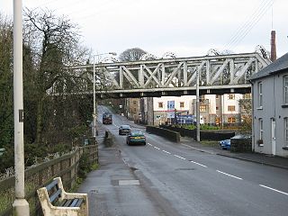
The Dromore Viaduct is an abandoned railway viaduct in Dromore, County Down, Northern Ireland.
Contents

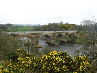
The Dromore Viaduct is an abandoned railway viaduct in Dromore, County Down, Northern Ireland.
The viaduct crosses the River Lagan. It is roughly 101m long and 6m wide, having been built to carry only a single track. The viaduct consists of seven arches, 10m apart, with the piers being 1.5m wide. The piers and abutments are made of ashlar blackstone, whilst the parapets, which stand a metre above arch level, are coped with chamfered sandstone. [1] The viaduct stands at 23 metres tall.
It was designed by Thomas Jackson of Messrs Greene & King, who built the line from Knockmore to Banbridge. Jackson was also responsible for designing Hillsborough and Dromore railway stations. [2]
Construction began in 1860 and was completed the following year, opening to railway traffic in 1863 with the first train on 13 July that year. Originally owned by the Banbridge, Lisburn and Belfast Junction Railway (Whose trains were run by the Ulster Railway), it became part of the Great Northern Railway in 1876. The line, and thus the viaduct, was closed on 30 April 1956 and the tracks lifted shortly after. [3]
In 2009, the PSNI was called to the viaduct after a group of teenagers broke onto and bungee jumped from it. [4]
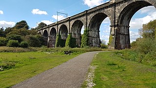
The viaduct is a listed building and has been since 1977. It is the property of Armagh, Banbridge and Craigavon Borough Council. Dromore Town Park passes underneath two of the arches, [5] though the ends have both been sealed off from public access. Floodlights have been installed under the arches and it is common to see it lit up blue overnight. [6]
A viaduct is a specific type of bridge that consists of a series of arches, piers or columns supporting a long elevated railway or road. Typically a viaduct connects two points of roughly equal elevation, allowing direct overpass across a wide valley, road, river, or other low-lying terrain features and obstacles. The term viaduct is derived from the Latin via meaning "road", and ducere meaning "to lead". It is a 19th-century derivation from an analogy with ancient Roman aqueducts. Like the Roman aqueducts, many early viaducts comprised a series of arches of roughly equal length.

The Ribblehead Viaduct or Batty Moss Viaduct carries the Settle–Carlisle railway across Batty Moss in the Ribble Valley at Ribblehead, in North Yorkshire, England. The viaduct, built by the Midland Railway, is 28 miles (45 km) north-west of Skipton and 26 miles (42 km) south-east of Kendal. It is a Grade II* listed structure. Ribblehead Viaduct is the longest and the third tallest structure on the Settle–Carlisle line.

The A1 is a major route in Northern Ireland. It runs from Belfast via Lisburn and Banbridge to the border with the Republic of Ireland south of Newry, from where the road continues to Dublin, becoming the N1 road and M1 motorway. Between Sprucefield and Carrickcarnan the road forms part of the European route E01.

Banbridge was a local government district in Northern Ireland. The district was one of 26 council areas formed on 1 October 1973, following the implementation of the Local Government Act 1972. The headquarters of the council were in the town of Banbridge. In April 2015, most of the Banbridge district was included in the merged Armagh, Banbridge and Craigavon district.

Dromore is a small market town and civil parish in County Down, Northern Ireland. It lies within the local government district of Armagh City, Banbridge and Craigavon. It is 19 miles (31 km) southwest of Belfast, on the A1 Belfast–Dublin road. The 2011 Census recorded a population of 6,003.
The Sankey Viaduct is a railway viaduct in North West England. It is a designated Grade I listed building and has been described as being "the earliest major railway viaduct in the world".

Donaghcloney or Donacloney is a village, townland and civil parish in County Down, Northern Ireland. It lies on the River Lagan between Lurgan and Dromore. In the 2011 Census it had a population of 1701. It is often colloquially referred to as The 'Cloney by locals.
Welland Viaduct, Harringworth Viaduct or Seaton Viaduct, crosses the valley of the River Welland between Harringworth in Northamptonshire and Seaton in Rutland, England.

The Belfast–Newry line operates from Lanyon Place station in County Antrim to Newry in County Down, Northern Ireland. The manager for this line is based at Portadown railway station, although the line extends to the border to include the Scarva and Poyntzpass halts and Newry. Newry is on the fringe of the network, being the last stop before the border with the Republic of Ireland. The line follows the route of the northern half of the main Dublin–Belfast line, with the exception of calling at Belfast Great Victoria Street.

Knockmore railway station was a station on the Belfast–Newry railway line. The station served the suburb of Knockmore in Lisburn, County Antrim, Northern Ireland. The Great Northern Railway (GNR) opened Knockmore station as a halt in 1932. Northern Ireland Railways (NIR) closed the station on 25 March 2005.

The Landore viaduct is a railway viaduct over the Swansea valley and the River Tawe at Landore in south Wales. It provides a link between Swansea city center and the West Wales Line to the South Wales Main Line. The valley crossing provides a panoramic view of Landore, Kilvey Hill, the Liberty Stadium and the Swansea Enterprise Park.

The Wharncliffe Viaduct is a brick-built viaduct that carries the Great Western Main Line railway across the Brent Valley, between Hanwell and Southall, Ealing, UK, at an elevation of 20 metres (66 ft). The viaduct, built in 1836–7, was constructed for the opening of the Great Western Railway (GWR). It is situated between Southall and Hanwell stations, the latter station being only a very short distance away to the east.

Stockport Viaduct carries the West Coast Main Line across the valley of the River Mersey in Stockport, Greater Manchester, England. It is one of the largest brick structures in the United Kingdom and a major structure of the early railway age. It is immediately north of Stockport railway station.

The London Road Viaduct is a brick railway viaduct in Brighton, part of the city of Brighton and Hove in East Sussex, England. It carries the East Coastway Line between Brighton and London Road railway stations. Built in the 1840s for the Brighton, Lewes and Hastings Railway by the locomotive engineer and railway architect John Urpeth Rastrick, the sharply curving structure has 27 arches and about 10 million bricks. It is still in constant use, and is listed at Grade II* for its historical and architectural significance.
Dromore railway station was on the Banbridge, Lisburn and Belfast Junction Railway which ran from Knockmore Junction to Banbridge in Northern Ireland.

The Seven Arches Bridge is a historic bridge in Newport, County Mayo, Ireland.

Dinting Viaduct is a 19th-century railway viaduct in Glossopdale in Derbyshire, England, that carries the Glossop Line over a valley at the village of Dinting. It crosses the Glossop Brook and the A57 road between Manchester and Sheffield.
The Crumlin Viaduct is a railway bridge in Crumlin, County Antrim. It has the distinction of being the only place in Ireland where a train, plane, car, and boat can theoretically cross paths, due to its unique status of being a railway bridge straddling a road bridge across a river, with Belfast International Airport two kilometers to the north.

The Bann Bridge is a railway bridge in Coleraine, County Londonderry. It is the only railway bascule bridge in Northern Ireland.

The Tassagh Viaduct is a railway viaduct near Tassagh, County Armagh, Northern Ireland. Tassagh Beetling Mill sits almost immediately beneath it.