The Lagan Valley is an area of Northern Ireland between Belfast and Lisburn. The River Lagan rises on Slieve Croob in County Down and flows generally northward discharging into Belfast Lough. For a section, the river forms part of the border between the counties of Antrim and Down.
The Laganside Corporation was a non-departmental public body formed by the Laganside Development Order 1989 with the goal of regenerating large sections of land in Belfast, Northern Ireland adjacent to the River Lagan. This development area was expanded in 1996 to include areas closer to the city centre.

Belfast Castle is a castle on the slopes of Cavehill Country Park in Belfast, Northern Ireland, in a prominent position 400 feet (120 m) above sea level. Its location provides unobstructed views over the City of Belfast and Belfast Lough. The current castle is a Victorian structure, built between 1867 and 1870, and is listed as being Grade B+. The main entrance into the Belfast Castle Demesne is now where Innisfayle Park meets Downview Park West, just off the Antrim Road. The original main entrance into the demesne was formerly on the Antrim Road itself, where Strathmore Park now meets the Antrim Road.
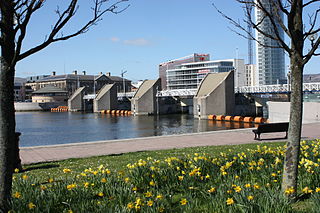
The Lagan Weir, in Belfast, Northern Ireland, crosses the River Lagan between the Queen Elizabeth Bridge and the M3 cross-harbour bridge. Prior to the building of the weir, the river would be subject to tidal fluctuations, and low tide would expose mudflats, which were unsightly and emitted a strong odour, particularly in the summer months. Opened in 1994, the weir was seen by the Laganside Corporation as a catalyst for its redevelopment projects and was judged to be the "centrepiece" of that effort. The weir also incorporates a footbridge.
The Albert Bridge is a bridge in Belfast, Northern Ireland. Its three flat arches span the River Lagan and it is one of eight bridges in the city. It was completed in 1890 by Belfast city surveyor J C Bretland after two arches of the previous bridge suddenly collapsed in 1886. It is located close to the city centre between East Bridge Street and the Albert Bridge Road.

Stranmillis is an area in south Belfast, Northern Ireland. It is also an electoral ward for Belfast City Council, part of the Laganbank district electoral area. As part of the Queen's Quarter, it is the location for prominent attractions such as the Ulster Museum and Botanic Gardens. The area is located on Stranmillis Road, with Malone Road to the west and the River Lagan to the east. Its name, meaning "the sweet stream" in Irish, refers to the Lagan, whose waters are still fresh at this point, before becoming brackish as the river flows onward toward its mouth in Belfast Lough.

The Lyric Theatre, or simply The Lyric, is the principal, full-time producing theatre in Belfast, Northern Ireland. The theatre was first established as The Lyric Players in 1951 at the home of its founders Mary O'Malley and her husband Pearse in Derryvolgie Avenue, off the Malone Road, and moved to its new site on Ridgeway Street in 1968, between the Stranmillis Road and Stranmillis Embankment. Austin Clarke laid the foundation stone in 1965 a deliberate choice by O'Malley to build a link back to her artistic hero W. B. Yeats.

Ormeau Park is the oldest municipal park in Belfast, Northern Ireland, having been officially opened to the public in 1871. It is owned and run by Belfast City Council and is one of the largest and busiest parks in the city and contains a variety of horticulture, woodland, wildlife and sporting facilities.

The Ormeau Road is a road in south Belfast, the largest city in Northern Ireland. Ormeau Park is adjacent to it. It forms part of the A24.

The Blackstaff River is a watercourse in County Antrim, Northern Ireland. It rises on the eastern slope of the Black Mountain before flowing down into the Bog Meadows and passing under the city of Belfast, where it enters the River Lagan. Much of its course has been culverted and built upon since the 19th century, making it largely invisible today. Its tributaries include the Forth or Clowney River, which meets it beneath the Broadway Roundabout in West Belfast.

The A55 road forms Belfast's outer-ring road.
Laganbank was one of the nine district electoral areas in Belfast, Northern Ireland which existed from 1985 to 2014. Located in the south of the city, the district elected five members to Belfast City Council and contained the wards of Ballynafeigh, Botanic, Shaftesbury, Stranmillis, and Rosetta. Laganbank, along with neighbouring Balmoral, formed the greater part of the Belfast South constituencies for the Northern Ireland Assembly and UK Parliament.
Pottinger was one of the nine district electoral areas (DEA) in Belfast, Northern Ireland from 1985 to 2014. Located in the east of the city, the district elected six members to Belfast City Council and contained the wards of Ballymacarrett, Bloomfield, Orangefield, Ravenhill, The Mount, and Woodstock.
The Belfast Urban Motorway was a proposed motorway system in Belfast, Northern Ireland announced in 1964, but was never completed, only the Western portion was built as the A12, Westlink. It was to be built in three phases: Phase 1, from the M1 at Broadway to the M2 at York Street; Phase 2, from the M2 at York Street across the River Lagan to the M3 at the bottom of the Newtownards Road; and Phase 3, from the Newtownards Road south through Short Strand, back across the River Lagan, through Shaftesbury Square to join the start at the M1.

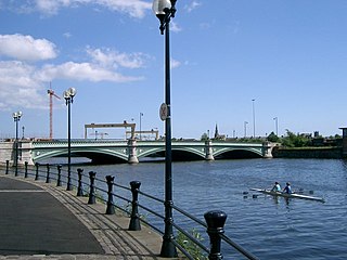
Lagan Railway Bridge is a railway and pedestrian bridge across the River Lagan in Belfast, slightly north of Belfast Central railway station. The next bridge upstream is the Albert Bridge, whilst the next downstream is Queen's Bridge.

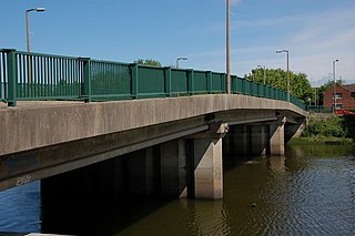
King's Bridge is a road bridge across the River Lagan in South Belfast, Northern Ireland. It opened in 1912 and is named after King George V. Made of reinforced concrete, it is believed to be the first road bridge of this type in Ireland.
Governor's Bridge is a road bridge in Stranmillis, south Belfast. It was inaugurated on 23 September 1974.

Shaw's Bridge is the name given to two adjacent bridges across the River Lagan in Belfast, Northern Ireland. The older of the bridges is a historic stone arched bridge, which is open to cyclists and pedestrians. The new bridge is a concrete bridge which carries the A55 road.
