It is situated at the northern edge of the Harz mountain range on the road from Ilsenburg and Drübeck to the town of Wernigerode in the east. The village has approximately 2.400 inhabitants, it consists of the southern part Darlingerode proper and the northern Altenrode.
The village was known as Turincwartesrot in early medieval times, since, according to a 12th-century entry, a man called Turincwart settled down here and inherited or donated the place to the Fulda monastery, between 780 and 820. It was possibly deserted for a long time - the first time the settlement again appeared is 5 May 1086, in a document of Bishop Burchard II of Halberstadt. This date is regarded as the foundation of the village, and consequently the 900-year-jubilee was celebrated in 1986.
The inhabitants lived on arable farming, but also on mining in the Harz mountains. It is assumed that Emperor Otto III held a court's day at an early medieval stone circle in Darlingerode. The foundations of the Romanesque village church, first mentioned in 1086, also date back to the Ottonian era. The estates belonged to the County of Wernigerode; from 1429, they were held by the Counts of Stolberg.
Village church
On 6 August 1517, Martin Luther visited Himmelpforten Abbey near the village, where he debated with the head of his order, Johann von Staupitz, about the so-called sale of indulgences. This may be a legend, nevertheless a memorial stone was erected 400 years later here. In the German Peasants' War of 1525, the monastery was taken and nearly destroyed by insurgents from Darlingerode and Wernigerode, the monks fled, returned for some decades, but left it in the end. Nowadays just some remains of the outer walls are to be seen.
During the Thirty Years' War, the area was repeatedly devastated by Imperial troops under Wallenstein and Tilly as well as by Swedish forces. The inhabitants probably were connected with people who fled into the near woods and defied the plundering troops, the Harzschützen movement.
Wernigerode is a town in the district of Harz, Saxony-Anhalt, Germany. Until 2007, it was the capital of the district of Wernigerode. Its population was 32,181 in 2020.
The Harz is a highland area in northern Germany. It has the highest elevations for that region, and its rugged terrain extends across parts of Lower Saxony, Saxony-Anhalt, and Thuringia. The name Harz derives from the Middle High German word Hardt or Hart. The name Hercynia derives from a Celtic name and could refer to other mountain forests, but has also been applied to the geology of the Harz. The Brocken is the highest summit in the Harz with an elevation of 1,141.1 metres (3,744 ft) above sea level. The Wurmberg is the highest peak located entirely within the state of Lower Saxony.
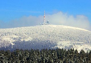
The Brocken, also sometimes referred to as the Blocksberg, is the highest peak in the Harz mountain range and also the highest peak in Northern Germany; it is near Schierke in the German state of Saxony-Anhalt between the rivers Weser and Elbe. Although its elevation of 1,141 metres (3,743 ft) is below alpine dimensions, its microclimate resembles that of mountains of about 2,000 m (6,600 ft). The peak above the tree line tends to have a snow cover from September to May, and mists and fogs shroud it up to 300 days of the year. The mean annual temperature is only 2.9 °C (37.2 °F). It is the easternmost mountain in northern Germany; travelling east in a straight line, the next prominent elevation would be in the Ural Mountains in Russia.
The County of Stolberg-Wernigerode was a county of the Holy Roman Empire located in the Harz region around Wernigerode, now part of Saxony-Anhalt, Germany. It was ruled by a branch of the House of Stolberg.
Ilsenburg is a town in the district of Harz, in Saxony-Anhalt in Germany. It is situated under the north foot of the Harz Mountains, at the entrance to the Ilse valley with its little river, the Ilse, a tributary of the Oker, about six 6 miles (9.7 km) north-west of the town of Wernigerode. It received town privileges in 1959. Owing to its surrounding of forests and mountains as well as its position on the edge of the Harz National Park, Ilsenburg is a popular tourist resort. Since 2002, it is officially an air spa.
Ilsenburg Abbey was a monastery of the Benedictine Order located at Ilsenburg near Wernigerode, in Saxony-Anhalt in Germany. The former abbey is a stop on the Romanesque Road.
Drübeck is a village and a former municipality in the district of Harz, in Saxony-Anhalt, Germany. Since 1 July 2009, it is part of the town Ilsenburg.
Stapelburg is a village and a former municipality in the district of Harz, in Saxony-Anhalt, Germany. Since 1 January 2010, it is part of the Nordharz municipality.
The County of Wernigerode was a state of the Holy Roman Empire which arose in the Harzgau region of the former Duchy of Saxony, at the northern foot of the Harz mountain range. The comital residence was at Wernigerode, now part of Saxony-Anhalt, Germany. The county was ruled by a branch of the House of Stolberg from 1429 until its mediatization to the Kingdom of Prussia in 1806. Nevertheless, the county remained in existence - with one short interruption - until the dissolution of the Kingdom of Prussia in 1918.
Wernigerode Castle is a schloss located in the Harz mountains above the town of Wernigerode in Saxony-Anhalt, Germany. The present-day building, finished in the late 19th century, is similar in style to Schloss Neuschwanstein, though its foundations are much older and have been reconstructed several times. Wernigerode Castle was first built at the beginning of the 12th century (1110-1120) as a Romanesque architecture medieval fortress for German emperors to have a secure spot to stop during their hunting trips to the Harz. Few of these medieval walls and foundation remain today. At the end of the 15th century the castle was enlarged in a Gothic architecture style, with large arched windows. During the 16th century, it was rebuilt as a Renaissance fortress. A spiral staircase tower still remains intact today.
Plessenburg is a village in the town of Ilsenburg in the Harz National Park, in the district of Harz in the German state of Saxony-Anhalt.
The Ahlsburg or Alerdestein was an Imperial castle near Stapelburg in the present-day Harz district, in the German state of Saxony-Anhalt.
The present-day Heudeber-Danstedt–Vienenburg railway is a 32 kilometre long main line, that serves the northern edge of the Harz Mountains in central Germany. Its main role is the handling of tourist traffic in the Harz and the Harz Narrow Gauge Railways there, but it is also worked by goods trains to and from the rolling mills in Ilsenburg.
Eckertal is a hamlet of about 160 inhabitants in Bad Harzburg in Lower Saxony, Germany.
Ilsenburg House stands in the town of Ilsenburg (Harz) in the German state of Saxony-Anhalt and was given its present appearance in the 2nd half of the 19th century. The structure was built from 1860 onwards on the west and north sides of the Romanesque monastery of Ilsenburg Abbey. The stately home, designed in the Neo-Romanesque style, was the seat of the princes of Stolberg-Wernigerode until 1945. Since 2005, it has been owned by the Ilsenburg Abbey Foundation.
The House of Stolberg is the name of an old and large German dynasty of the former Holy Roman Empire's high aristocracy. Members of the family held the title of Fürst and Graf. They played a significant role in feudal Germany's history and, as a mediatized dynasty, enjoyed princely privileges until the collapse of the German Empire in 1918. The house has numerous branches.
The Ilse valley is the ravine of the Ilse stream in the northern boundary of the Harz mountain range in Germany. Part of the Harz National Park, it runs from the town of Ilsenburg at the foot of the mountain range up to the source region near the summit of the Brocken massif, the highest mountain of the range. The scenic valley is a popular hiking area.
The Ilsestein is a prominent granite rock formation near the town of Ilsenburg in the Harz mountains of central Germany. Offering a scenic view over the Ilse valley to the Brocken massif, the highest mountain of the range, it is today a popular tourist destination.
The Scharfenstein is a mountain, 697.6 m above sea level (NN) high, in the Harz Mountains of Germany, near Ilsenburg in the district of Harz in Saxony-Anhalt. It is part of the Harz National Park.
This page is based on this Wikipedia article Text is available under the CC BY-SA 4.0 license; additional terms may apply. Images, videos and audio are available under their respective licenses.