
The River Rother flows for 35 miles (56 km) through the English counties of East Sussex and Kent. Its source is near Rotherfield in East Sussex, and its mouth is on Rye Bay, part of the English Channel. Prior to 1287, its mouth was further to the east at New Romney, but it changed its course after a great storm blocked its exit to the sea. It was known as the Limen until the sixteenth century. For the final 14 miles (23 km), the river bed is below the high tide level, and Scots Float Sluice is used to control levels. It prevents salt water entering the river system at high tides, and retains water in the river during the summer months to ensure the health of the surrounding marsh habitat. Below the sluice, the river is tidal for 3.7 miles (6.0 km).
Blithfield Reservoir is a large raw water reservoir in Staffordshire, England, owned by South Staffordshire Water.
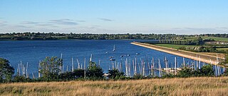
Draycote Water is a 240-hectare (590-acre) reservoir and country park near the village of Dunchurch, 3.75 miles (6 km) south of Rugby in Warwickshire, England, owned and operated by Severn Trent Water. It draws its water from the River Leam, and supplies drinking water to Rugby and Coventry. It is named after the nearby hamlet of Draycote and is the largest body of water within Warwickshire.

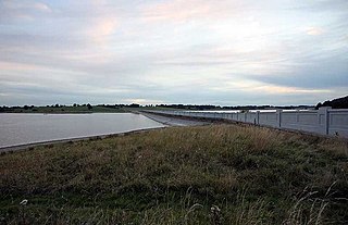
Grafham Water is an 806.3-hectare (1,992-acre) biological Site of Special Scientific Interest (SSSI) north of Perry, Huntingdonshire. It was designated an SSSI in 1986. It is a reservoir with a circumference of about 16 km (10 mi), is 21 m (69 ft) deep at maximum, and is the eighth largest reservoir in England by volume and the third largest by area at 6.27 km2. An area of 114 ha at the western end is a nature reserve managed by the Wildlife Trust for Bedfordshire, Cambridgeshire and Northamptonshire.
Ardingly Reservoir is west of Ardingly in West Sussex. The southern end is a 74.5-hectare (184-acre) Local Nature Reserve owned and managed by South East Water.

Devilbend Natural Features Reserve is a 1,005 ha natural reserve park in the rural locality of Tuerong on the Mornington Peninsula in central southern Victoria, Australia, 55 km (34 mi) southeast of the state capital Melbourne's city center.

Mountfield is a village and civil parish in the Rother district of East Sussex, England, and three miles (5 km) north-west of Battle. It is mentioned in the Domesday Book.

Brede is a village and civil parish in the Rother district of East Sussex, England. It is located eight miles (13 km) north of Hastings and four miles (6 km) west of Rye.

Agden Reservoir is a water storage reservoir, situated at grid reference SK260925, 6.5 miles (10 km) west of the centre of Sheffield, South Yorkshire, England. It is owned by Yorkshire Water / Kelda Group. The reservoir covers an area of 25 hectares (62 acres) and has a capacity of 559 million gallons (2.11x10⁹ litres) of water, the dam wall has a width of approximately 380 feet (120 m) with a height of 100 feet (30 m). 'Agden' means 'Valley of the Oak Trees'.

The Whiskeytown–Shasta–Trinity National Recreation Area is a United States National Recreation Area in northern California. The recreation area was authorized in 1965 by the United States Congress. Recreational activities available include swimming, fishing, boating, camping, and hiking.

Weir Wood Reservoir is a 153.5-hectare (379-acre) biological Site of Special Scientific Interest west of Forest Row in East Sussex. It is in High Weald Area of Outstanding Natural Beauty and an area of 32.6 hectares is a Local Nature Reserve which is owned by Southern Water and managed by East Sussex County Council and Southern Water.

Hanningfield Reservoir is a large 25,500-million-litre (900,000,000 cu ft) pumped storage reservoir located between Billericay and Chelmsford in Essex. It has a surface area of 352 hectares and is owned and operated by Essex and Suffolk Water.
Burrs Country Park covers a 36 hectare site on the banks of the River Irwell, in the town of Bury, Greater Manchester, England. It was acquired by Bury Metropolitan Borough Council in 1986 and transformed from a derelict industrial site into a modern country park.

Sussex is a historic county and cultural region in the south of England corresponding roughly in area to the ancient Kingdom of Sussex. It is bounded on the north by Surrey, north-east by Kent, south by the English Channel, and west by Hampshire, and is divided for local government into West Sussex and East Sussex and the city of Brighton and Hove. The city of Brighton & Hove was created a unitary authority in 1997, and was granted City status in 2000. Until then Chichester had been Sussex's only city. By convention, Chichester is Sussex's capital city and Lewes is Sussex's county town.
Macclesfield Forest is an area of woodland, predominantly conifer plantation, around 3 mi (5 km) south east of Macclesfield in the civil parish of Macclesfield Forest and Wildboarclough, in Cheshire, England.

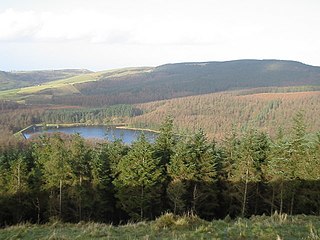
Darwell Wood is a 37.5-hectare (93-acre) biological Site of Special Scientific Interest north-west of Battle in East Sussex.
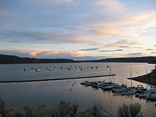
Navajo State Park is a state park of Colorado, USA, on the north shore of Navajo Lake. Touted as Colorado's answer to Lake Powell, this reservoir on the San Juan River begins in Colorado's San Juan Mountains and extends 20 miles (32 km) into New Mexico. Its area is 15,000 acres (6,100 ha), and it has 150 miles (240 km) of shoreline in two states. Park activities include boating, houseboating, fishing, camping, and wildlife viewing. There is a New Mexico state park at the southern end of the lake.

Rivelin Dams are a pair of water storage reservoirs situated in the upper part of the Rivelin Valley, 5 miles (8 km) west of Sheffield in South Yorkshire, England. The dams are owned by Yorkshire Water and provide water to 319,000 people as well as compensation water for the River Rivelin. They are named Upper and Lower and fall just within the eastern boundary of the Peak District.

Eliburn is an area, primarily residential, in Livingston, West Lothian, Scotland. Eliburn is bordered by Deans to the north, Ladywell to the east and Livingston Village to the south.

Vinehall Street, is a linear settlement in the civil parishes of Mountfield and Whatlington, and the Rother district of East Sussex, England. Vinehall School is situated in Vinehill Street.
