
Mobile Bay is a shallow inlet of the Gulf of Mexico, lying within the state of Alabama in the United States. Its mouth is formed by the Fort Morgan Peninsula on the eastern side and Dauphin Island, a barrier island on the western side. The Mobile River and Tensaw River empty into the northern end of the bay, making it an estuary. Several smaller rivers also empty into the bay: Dog River, Deer River, and Fowl River on the western side of the bay, and Fish River on the eastern side. Mobile Bay is the fourth-largest estuary in the United States with a discharge of 62,000 cubic feet (1,800 m3) of water per second. Annually, and often several times during the summer months, the fish and crustaceans will swarm the shallow coastline and shore of the bay. This event, appropriately named a jubilee, draws a large crowd because of the abundance of fresh, easily caught seafood.

Dauphin Island is an island town in Mobile County, Alabama, United States, on a barrier island of the same name, in the Gulf of Mexico. It incorporated in 1988. The population was 1,778 at the 2020 census, up from 1,238 at the 2010 census. The town is part of the Mobile metropolitan area. The island was renamed for Louis XIV of France's great-grandson and heir, the dauphin, the future Louis XV of France. The name of the island is often mistaken as Dolphin Island; the word dauphin is French for dolphin, but historically, the term was used as the title of the heir apparent to the French monarch.

The National Aquarium – also known as National Aquarium in Baltimore and formerly known as Baltimore Aquarium – is a non-profit public aquarium located at 501 East Pratt Street on Pier 3 in the Inner Harbor area of downtown Baltimore, Maryland in the United States. Constructed during a period of urban renewal in Baltimore, the aquarium opened on August 8, 1981. The aquarium has an annual attendance of 1.5 million visitors and is the largest tourism attraction in the State of Maryland. The aquarium holds more than 2,200,000 US gallons (8,300,000 L) of water, and has more than 17,000 specimens representing over 750 species. The National Aquarium's mission is to inspire conservation of the world's aquatic treasures. The aquarium's stated vision is to confront pressing issues facing global aquatic habitats through pioneering science, conservation, and educational programming.

The Mobile River is located in southern Alabama in the United States. Formed out of the confluence of the Tombigbee and Alabama rivers, the approximately 45-mile-long (72 km) river drains an area of 44,000 square miles (110,000 km2) of Alabama, with a watershed extending into Mississippi, Georgia, and Tennessee. Its drainage basin is the fourth-largest of primary stream drainage basins entirely in the United States. The river has historically provided the principal navigational access for Alabama. Since construction of the Tennessee-Tombigbee Waterway, it also provides an alternative route into the Ohio River watershed.

The Maritime Aquarium at Norwalk is an aquarium located in the South Norwalk section of Norwalk, Connecticut.
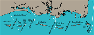
The Mississippi Sound is a sound along the Gulf Coast of the United States. It runs east-west along the southern coasts of Mississippi and Alabama, from the mouth of the Pearl River at the Mississippi-Louisiana state border to the Dauphin Island Bridge, a distance of about 90 miles (145 km). The sound is separated from the Gulf on its southern side by the Mississippi–Alabama barrier islands: Cat, Ship, Horn, West Petit Bois, Petit Bois, and Dauphin. Ship, Horn, West Petit Bois and Petit Bois Islands are part of the National Park Service's Gulf Islands National Seashore. Those islands separate the sound from the Gulf of Mexico. The sediment of the islands was created partly by the ancient Mississippi River when the St. Bernard Lobe of the Mississippi Delta was active over two thousand years ago. The expansion of the St. Bernard subdelta slowly isolated the Mississippi Sound from ocean dynamics of the open Gulf of Mexico.
Indian Mound Park, also known as Shell Mound Park or Indian Shell Mound Park, is a park and bird refuge located on the northern shore of Dauphin Island, a barrier island of Mobile County, Alabama in the United States. In addition to the many birds which visit, a wide variety of botanical species contribute to the natural offerings. The site is historically significant due to the presence of prehistoric Indian shell middens, mounds composed of discarded oyster shells. The park was added to the National Register of Historic Places on August 14, 1973. It is administered by the Alabama Department of Conservation and Natural Resources.

The South Carolina Aquarium, located in Charleston, South Carolina, opened on May 19, 2000, on the historic Charleston Harbor in the former location of the Anson Borough Homes, a public housing project that was closed over soil contamination and flooding concerns. It is home to more than ten thousand plants and animals including North American river otters, alligators, great blue herons, owls, pythons, loggerhead sea turtles, lined seahorses, jellyfish, pufferfish, green moray eels, horseshoe crabs, sea stars, and sharks. The largest exhibit at the aquarium is the Great Ocean Tank, which extends from the first to the third floor of the Aquarium and is the deepest tank in North America ; it holds more than 385,000 US gallons (1,460,000 L) of water and contains more than 700 animals. The Aquarium also features a Touch Tank, where patrons may touch horseshoe crabs, Atlantic stingrays, and other marine animals.

Phyllorhiza punctata is a species of jellyfish, also known as the floating bell, Australian spotted jellyfish, brown jellyfish or the white-spotted jellyfish. It is native to the western Pacific from Australia to Japan, but has been introduced widely elsewhere. It feeds primarily on zooplankton. P. punctata generally can reach up to 50 centimetres (20 in) in bell diameter, but in October 2007, one 74 cm (29 in) wide, perhaps the largest ever recorded, was found on Sunset Beach, North Carolina.

The Texas State Aquarium is a nonprofit aquarium located in Corpus Christi, Texas, United States. The aquarium aims to promote environmental conservation and rehabilitation of the wildlife of the Gulf of Mexico and has been accredited by the Association of Zoos and Aquariums (AZA) since 1995. Currently the largest aquarium in Texas and also one of the largest aquaria in the United States.

Interstate 10 (I-10) is a part of the Interstate Highway System that runs from Santa Monica, California, to Jacksonville, Florida. In Alabama, the Interstate Highway runs 66.269 miles (106.650 km) from the Mississippi state line near Grand Bay east to the Florida state line at the Perdido River. I-10 is the primary east–west highway of the Gulf Coast region of Alabama. The highway connects Mobile, the largest city in South Alabama, with Pascagoula, Mississippi, to the west and Pensacola, Florida, to the east. Within the state, the highway connects Mobile and Mobile County with the Baldwin County communities of Daphne and Fairhope. I-10 connects Mobile and Baldwin County by crossing the northern end of Mobile Bay and the southern end of the Mobile-Tensaw River Delta via the George Wallace Tunnel in Mobile and the Jubilee Parkway viaduct system between Mobile and Daphne.

The Virginia Aquarium & Marine Science Center, formerly known as the Virginia Marine Science Museum, is an aquarium and marine science museum located in Virginia Beach, Virginia, just south of Rudee Inlet. The exhibits at the museum are contained in over 800,000 US gallons (3,028,000 L) of fresh and saltwater displays.

The Northern Gulf Institute (NGI) is a National Oceanic and Atmospheric Administration (NOAA) Cooperative Institute started in October 2006. It is one of 20 NOAA Cooperative Institutes (CIs). The NGI is a partnership of six academic institutions and NOAA. The collaboration led by Mississippi State University (MSU), includes the University of Southern Mississippi (USM), Louisiana State University (LSU), Florida State University (FSU), the University of Alabama in Huntsville, and the Dauphin Island Sea Lab (DISL). The NGI defines the Northern Gulf of Mexico region as the upland, watershed, coastal zone, and coastal ocean areas from the Sabine River in Louisiana east to the Suwannee River in Florida.

The Mobile–Tensaw River Delta is the largest river delta and wetland in Alabama. It encompasses approximately 260,000 acres (110,000 ha) in a 40-by-10-mile area and is the second largest delta in the contiguous United States. This large river delta is approximately 45 miles long and averages 8 miles wide, being 16 miles wide at its widest point. It covers approximately 300 square miles. Of its 260,000 acres, 20,000 acres consist of open water, 10,000 acres of marsh, 70,000 acres of swamp; and more than 85,000 acres of bottomland forest. It drains an area of about 44,000 sq miles, which includes 64% of Alabama and small portions of Georgia and Mississippi.

The Pensacola culture was a regional variation of the Mississippian culture along the Gulf Coast of the United States that lasted from 1100 to 1700 CE. The archaeological culture covers an area stretching from a transitional Pensacola/Fort Walton culture zone at Choctawhatchee Bay in Florida to the eastern side of the Mississippi River Delta near Biloxi, Mississippi, with the majority of its sites located along Mobile Bay in the Mobile-Tensaw River Delta. Sites for the culture stretched inland, north into the southern Tombigee and Alabama River valleys, as far as the vicinity of Selma, Alabama.

Ripley's Aquarium of Canada is a public aquarium in Toronto, Ontario, Canada. The aquarium is one of three aquariums owned-and-operated by Ripley Entertainment. It is located in downtown Toronto, just southeast of the CN Tower. The aquarium has 5.7 million litres of marine and freshwater habitats from across the world. The exhibits hold more than 20,000 exotic sea and freshwater specimens from more than 450 species.

Gulf Specimen Marine Laboratory (GSML) is an independent not-for-profit marine research and education organization and public aquarium in Panacea, Florida, United States.

Eilat's Coral World Underwater Observatory is a public aquarium, park and conservation center located in Eilat, Israel. It is the biggest public aquarium in Israel, and it hosts over 800 species. It was founded in 1974 and was the first of its kind. The park and aquarium is located to the south of Eilat's Coral Beach nature reserve.

Jakarta Aquarium and Safari is a marine and freshwater aquarium located within a retail and leisure complex Neo Soho in Jakarta, Indonesia. The aquarium is home to hundreds of mammal, reptile, insect and various types of Indonesian marine fish, is to introduce to the next generation the biodiversity of the archipelago starting from islands, forests, and mangroves.
The Mississippi–Alabama barrier islands are a chain of barrier islands in the Gulf of Mexico along the coasts of Mississippi and Alabama enclosing the Mississippi Sound. The major islands are Cat Island, Ship Island, Horn Island, Petit Bois Island, and Dauphin Island; in the early 20th century the chain also included the Isle of Caprice, which has since been submerged. The islands are separated by wide inlets, several of which have been channelized to form the shipping channels for Gulf coast ports. The shapes and sizes of the islands have changed significantly since the 1800s, with the islands generally shrinking and shifting westward, especially after major tropical cyclones. Most of the islands are uninhabited. Much of the Mississippi portion of the chain is included in the Gulf Islands National Seashore.


