This article needs additional citations for verification .(November 2024) |
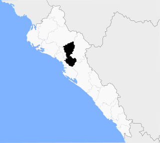
Dautillos is a town in the municipality of Navolato, Mexico. It is one meter above sea level. [1]
This article needs additional citations for verification .(November 2024) |
Dautillos is a town in the municipality of Navolato, Mexico. It is one meter above sea level. [1]
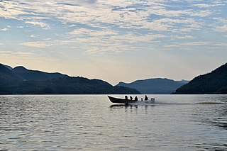
Dautillos inhabitants live off of the sea. Fishing and aquaculture are dominant forms of agriculture in the area. Mangrove swamps cover much of the shores of Dautillos. Native fauna include Frigate birds, Ospreys, seagulls, and pelicans. Deer are scarce in the desert surrounding Dautillos. People gather Clams, various fishes, and crabs. During Autumn and early winter, Prawn trawling takes over the fishing village as the main produce. Dautillos also has many Mango and palm trees that are common throughout the coastal region of Sinaloa.
Dautillos is home for 2270 inhabitants. About 59 percent of the local population are adults. While the medium quantity of years at school is 7.45 years, there are still about 100 persons who don't know write or read. 8 people are of indigenous origin and a total of 1 individuals older than 5 years still speak an indigenous language.
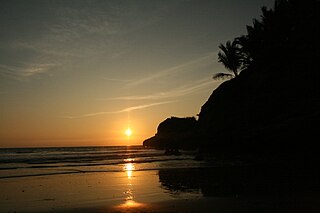
Dautillos has a few clean beaches that have been cleared of Mangrove but many residents go to El Tambor, a beach that is on the Pacific Ocean. Recreational activities include fishing and ATV riding on the nearby sand dunes. Dautillos is located 47 miles from Culiacan.
The area surrounding Dautillos is arid and desert like. Dautillos lies in the Bay of Santa Maria surrounded by estuaries. To the west of Dautillos is the Pacific Ocean and to the East there is the distant mountain range of the Sierra Madre Occidental. Dautillos' climate is hot and humid in the summer and fall and, cooling down in winter, and rises steadily in the spring.

The Gulf of California, also known as the Sea of Cortés or Sea of Cortez, or less commonly as the Vermilion Sea, is a marginal sea of the Pacific Ocean that separates the Baja California peninsula from the Mexican mainland. It is bordered by the states of Baja California, Baja California Sur, Sonora, and Sinaloa with a coastline of approximately 4,000 km (2,500 mi). Rivers that flow into the Gulf of California include the Colorado, Fuerte, Mayo, Sinaloa, Sonora, and the Yaqui. The surface of the gulf is about 160,000 km2 (62,000 sq mi). Maximum depths exceed 3,000 meters (9,800 ft) because of the complex geology, linked to plate tectonics.

Baja California Sur, officially Estado Libre y Soberano de Baja California Sur, is the least populated state and the last state to be admitted to Mexico, in 1974. It is also the ninth-largest Mexican state in terms of area.
Nayarit, officially the Estado Libre y Soberano de Nayarit, is one of the 31 states that, along with Mexico City, comprise the Federal Entities of Mexico. It is divided in 20 municipalities and its capital city is Tepic.
Ilha de Itamaracá is a tropical island and municipality in Pernambuco, Brazil on the Atlantic Ocean. Itamaracá means "stone shaker" in Tupi, from the words itá ("stone") and mbara'ká ("shaker"). It is separated from the mainland by the Canal de Santa Cruz, a salt water channel both mouths of which are on the Atlantic Ocean, and is connected to the mainland by a long road bridge.

Mazatlán is a city in the Mexican state of Sinaloa. The city serves as the municipal seat for the surrounding municipio, known as the Mazatlán Municipality. It is located on the Pacific coast across from the southernmost tip of the Baja California Peninsula.
Navolato is a city in the Mexican state of Sinaloa. It is located in the central coastal part of the state bordering the Gulf of California and serves as the municipal seat for the surrounding municipality of the same name.

Zihuatanejo, and/or Ixtapa-Zihuatanejo, is the fourth largest city in the Mexican state of Guerrero. It was known by 18th-century English mariners as Chequetan and/or Seguataneo. Politically the city belongs to the municipality of Zihuatanejo de Azueta in the western part of Guerrero, but both are commonly referred to as Zihuatanejo. It is on the Pacific Coast, about 240 km northwest of Acapulco. Zihuatanejo belongs to a section of the Mexican Pacific Coast known as the Costa Grande. This town has been developed as a tourist attraction along with the modern tourist resort of Ixtapa, 5 km (3.1 mi) away. However, Zihuatanejo has kept its traditional town feel. The town is located on a well-protected bay which is popular with private boat owners during the winter months.

San Felipe is a coastal city in San Felipe Municipality, Baja California, located on the Gulf of California. The population of San Felipe was reported as 17,143 inhabitants in the 2020 Mexican Census. San Felipe is historically a fishing town. Today it is also a popular tourist destination, known for its beaches, nature, and desert racing, as home to the San Felipe 250.

Los Cabos is a municipality located at the southern tip of Mexico's Baja California Peninsula, in the state of Baja California Sur. It encompasses the two towns of Cabo San Lucas and San José del Cabo linked by a thirty-two-km Resort Corridor of beach-front properties and championship golf courses.
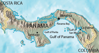
The Gulf of Panama is a gulf of the Pacific Ocean off the southern coast of Panama, where most of eastern Panama's southern shores adjoin it. The Gulf has a maximum width of 250 kilometres, a maximum depth of 220 metres (722 ft) and the size of 2,400 square kilometres (930 sq mi). The Panama Canal connects the Gulf of Panama with the Caribbean Sea, thus linking the Pacific and Atlantic oceans. The Panamanian capital Panama City is the main urban centre on the gulf shore.

Altata is a small town in Navolato Municipality connected to the Pacific Ocean, located about 45 miles west of Culiacán, Sinaloa in Mexico by Freeway 30.
Tecuala is both a municipality and a town in the Mexican state of Nayarit, on the Pacific coast. The population of the municipality was 42,237 in a total area of 1,137 km² (2000) while the population of the town and municipal seat was 14,584 (2000). One of the longest beaches in the world, Playa Novillero, is located here.

Pedasí is one of five districts of the Los Santos Province, Panama.

Chacala is a beach town set in small cove on the Pacific coast of Mexico in the State of Nayarit. It is located near pueblo Las Varas, about 100 kilometers (62 mi) north of Puerto Vallarta, and is part of the coastline known as the Riviera Nayarita. The name means "where there are shrimp" in Náhuatl. The population consists of approximately 300 full-time residents but can swell to over 1000 during Mexico's most popular vacation periods, such as Semana Santa and Christmas. Chacala is known for its physical beauty and unhurried lifestyle.

Timbiqui is a town and municipality in the Cauca Department, Colombia. It is located on the Pacific Coast of Colombia on the estuary of the Timbiqui River. An earthquake affected its inhabitants on the first of October, 2012.

The Costa Chica of Guerrero is an area along the south coast of the state of Guerrero, Mexico, extending from just south of Acapulco to the Oaxaca border. Geographically, it consists of part of the Sierra Madre del Sur, a strip of rolling hills that lowers to coastal plains to the Pacific Ocean. Various rivers here form large estuaries and lagoons that host various species of commercial fish.
Mompiche is a small beach town located on the coast of Ecuador in the province of Esmeraldas in South America.
Municipality of Mocorito is a municipality in the Mexican state of Sinaloa in northwestern Mexico. It is bordered to the north by the municipality of Sinaloa, to the south by Navolato, to the southeast by Culiacán, to the east by Badiraguato and to the west with Salvador Alvarado and Angostura. It encompasses a total of 2,800.6 km² and represents 4.9% of the territory of Sinaloa. According to the 2020 census it had a population of 40,358, compromising 270 total localities. Major localities include Pericos, Mocorito, and Caimanero.

Nuquí is a municipality and town in the Chocó Department, Colombia. The municipality of Nuquí is located in the department of Chocó in the Western part of Colombia between the mountainous area of Baudó and the Pacific Ocean. Nuquí has a great cultural diversity as well as a big variety of flora and fauna. Nuquí has 8096 inhabitants, 3095 of which live in the municipal capital. The majority of the population are Afro-Colombians, another part of the population is represented by members of indigenous tribes. Nuquí was founded as a municipality in 1915, before it was a sub-division of the municipality Valle, Chocó.
El Ostional is a coastal town on the Pacific Ocean, in the municipality of San Juan del Sur and Rivas department in south-west Nicaragua. It is located 170 kilometers south of Managua and 10.5 kilometers from the border with Costa Rica. The region consists of the communities of Monte Cristo and San Antonio. El Ostional is becoming recognized as a quaint spot for voluntourism, sport fishing, birdwatching, turtle, dolphin, and whale watching, Cultural heritage events and is a vacation spot for Nicaraguan families and foreign tourists interested in immersing themselves in rural community life.