
Erosion is the action of surface processes that removes soil, rock, or dissolved material from one location on the Earth's crust and then transports it to another location where it is deposited. Erosion is distinct from weathering which involves no movement. Removal of rock or soil as clastic sediment is referred to as physical or mechanical erosion; this contrasts with chemical erosion, where soil or rock material is removed from an area by dissolution. Eroded sediment or solutes may be transported just a few millimetres, or for thousands of kilometres.
Soil erosion is the denudation or wearing away of the upper layer of soil. It is a form of soil degradation. This natural process is caused by the dynamic activity of erosive agents, that is, water, ice (glaciers), snow, air (wind), plants, and animals. In accordance with these agents, erosion is sometimes divided into water erosion, glacial erosion, snow erosion, wind (aeolian) erosion, zoogenic erosion and anthropogenic erosion such as tillage erosion. Soil erosion may be a slow process that continues relatively unnoticed, or it may occur at an alarming rate causing a serious loss of topsoil. The loss of soil from farmland may be reflected in reduced crop production potential, lower surface water quality and damaged drainage networks. Soil erosion could also cause sinkholes.

Geomorphology is the scientific study of the origin and evolution of topographic and bathymetric features generated by physical, chemical or biological processes operating at or near Earth's surface. Geomorphologists seek to understand why landscapes look the way they do, to understand landform and terrain history and dynamics and to predict changes through a combination of field observations, physical experiments and numerical modeling. Geomorphologists work within disciplines such as physical geography, geology, geodesy, engineering geology, archaeology, climatology, and geotechnical engineering. This broad base of interests contributes to many research styles and interests within the field.

Noah's Ark is the ship in the Genesis flood narrative through which God spares Noah, his family, and examples of all the world's animals from a global deluge. The story in Genesis is based on earlier flood myths originating in Mesopotamia, and is repeated, with variations, in the Quran, where the Ark appears as Safinat Nūḥ and al-fulk. The myth of the global flood that destroys all life begins to appear in the Old Babylonian Empire period. The version closest to the biblical story of Noah, as well as its most likely source, is that of Utnapishtim in the Epic of Gilgamesh.

In geology, catastrophism is the theory that the Earth has largely been shaped by sudden, short-lived, violent events, possibly worldwide in scope. This contrasts with uniformitarianism, according to which slow incremental changes, such as erosion, brought about all the Earth's geological features. The proponents of uniformitarianism held that the present was "the key to the past", and that all geological processes throughout the past resembled those that can be observed today. Since the 19th-century disputes between catastrophists and uniformitarians, a more inclusive and integrated view of geologic events has developed, in which the scientific consensus accepts that some catastrophic events occurred in the geologic past, but regards these as explicable as extreme examples of natural processes which can occur.

The Missoula floods were cataclysmic glacial lake outburst floods that swept periodically across eastern Washington and down the Columbia River Gorge at the end of the last ice age. These floods were the result of periodic sudden ruptures of the ice dam on the Clark Fork River that created Glacial Lake Missoula. After each ice dam rupture, the waters of the lake would rush down the Clark Fork and the Columbia River, flooding much of eastern Washington and the Willamette Valley in western Oregon. After the lake drained, the ice would reform, creating Glacial Lake Missoula again.

Flood geology is a pseudoscientific attempt to interpret and reconcile geological features of the Earth in accordance with a literal belief in the Genesis flood narrative, the flood myth in the Hebrew Bible. In the early 19th century, diluvial geologists hypothesized that specific surface features provided evidence of a worldwide flood which had followed earlier geological eras; after further investigation they agreed that these features resulted from local floods or from glaciers. In the 20th century, young-Earth creationists revived flood geology as an overarching concept in their opposition to evolution, assuming a recent six-day Creation and cataclysmic geological changes during the biblical flood, and incorporating creationist explanations of the sequences of rock strata.

Rochechouart impact structure or Rochechouart astrobleme is an impact structure in France. Erosion has over the millions of years mostly destroyed its impact crater, the initial surface expression of the asteroid impact leaving highly deformed bedrock and fragments of the crater's floor as evidence of it.

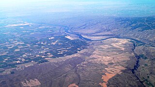
The Channeled Scablands are a relatively barren and soil-free region of interconnected relict and dry flood channels, coulees and cataracts eroded into Palouse loess and the typically flat-lying basalt flows that remain after cataclysmic floods within the southeastern part of Washington state. The Channeled Scablands were scoured by more than 40 cataclysmic floods during the Last Glacial Maximum and innumerable older cataclysmic floods over the last two million years. These floods were periodically unleashed whenever a large glacial lake broke through its ice dam and swept across eastern Washington and down the Columbia River Plateau during the Pleistocene epoch. The last of the cataclysmic floods occurred between 18,200 and 14,000 years ago.
Women in geology concerns the history and contributions of women to the field of geology. There has been a long history of women in the field, but they have tended to be under-represented. In the era before the eighteenth century, science and geological science had not been as formalized as they would become later. Hence early geologists tended to be informal observers and collectors, whether they were male or female. Notable examples of this period include Hildegard of Bingen who wrote works concerning stones and Barbara Uthmann who supervised her husband's mining operations after his death. Mrs. Uthmann was also a relative of Georg Agricola. In addition to these names varied aristocratic women had scientific collections of rocks or minerals.

Stream restoration or river restoration, also sometimes referred to as river reclamation, is work conducted to improve the environmental health of a river or stream, in support of biodiversity, recreation, flood management and/or landscape development.

Large woody debris (LWD) are the logs, sticks, branches, and other wood that falls into streams and rivers. This debris can influence the flow and the shape of the stream channel. Large woody debris, grains, and the shape of the bed of the stream are the three main providers of flow resistance, and are thus, a major influence on the shape of the stream channel. Some stream channels have less LWD than they would naturally because of removal by watershed managers for flood control and aesthetic reasons.
Channel patterns are found in rivers, streams, and other bodies of water that transport water from one place to another. Systems of branching river channels dissect most of the sub-aerial landscape, each in a valley proportioned to its size. Whether formed by chance or necessity, by headward erosion or downslope convergence, whether inherited or newly formed. Depending on different geological factors such as weathering, erosion, depositional environment, and sediment type, different types of channel patterns can form.
The Porcupine Hills Formation is a stratigraphic unit of middle to late Paleocene age in the Western Canada Sedimentary Basin. It takes its name from the Porcupine Hills of southwestern Alberta, and was first described in outcrop by George Mercer Dawson in 1883.
Giant current ripples, giant gravel bars, gravel dunes or GCRs are a form of subaqueous dune. They are active channel topographic forms up to 20 m high, which occur within near-thalweg areas of the main outflow routes created by glacial lake outburst floods. Giant current ripple marks are large scale analogues of small current ripples formed by sand in streams. Giant current ripple marks are important features associated with scablands. As a landscape component, they are found in several areas that were previously in the vicinity of large glacial lakes.
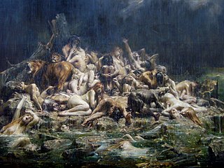
The Genesis flood narrative is a Hebrew flood myth. It tells of God's decision to return the universe to its pre-creation state of watery chaos and remake it through the microcosm of Noah's ark.
The Council Grove Group is a geologic group in Kansas, Oklahoma, and Nebraska as well as subsurface Colorado. It preserves fossils dating to the Carboniferous-Permian boundary. This group forms the foundations and lower ranges of the Flint Hills of Kansas, underlying the Chase Group that forms the highest ridges of the Flint Hills.
The Sulphur Mountain Formation is a geologic formation of Early to Middle Triassic age. It is present on the western edge of the Western Canada Sedimentary Basin in the foothills and Rocky Mountains of western Alberta and northeastern British Columbia. It includes marine fossils from the time shortly after the Permian-Triassic extinction event.
The Kootenay Group, originally called the Kootenay Formation, is a geologic unit of latest Jurassic to earliest Cretaceous age in the Western Canada Sedimentary Basin that is present in the southern and central Canadian Rockies and foothills. It includes economically important deposits of high-rank bituminous and semi-anthracite coal, as well as plant fossils and dinosaur trackways.
The geology of the Bay of Biscay formed as the North Atlantic opened during the late Cretaceous. Near shore, thinned continental crust shows signs of complicated stress patterns, while basalt oceanic crust lies beneath deep water offshore. Geologists have debated whether the bay opened in a simple rotation "scissor pattern" or through left-lateral strike slip faulting.
