Yellow Medicine County is a county in the State of Minnesota. Its eastern border is formed by the Minnesota River. As of the 2010 United States Census, the population was 10,438. Its county seat is Granite Falls.

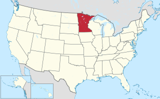
Lac qui Parle County is a county in the U.S. state of Minnesota. As of the 2010 United States Census, the population was 7,259. Its county seat is Madison.

Chippewa County is a county in the U.S. state of Minnesota. As of the 2010 United States Census, the population was 12,441. Its county seat is Montevideo. The county was formed in 1862, and was organized in 1868.

Bellingham is a city in Lac qui Parle County, Minnesota, United States. The population was 168 at the 2010 census.

Dawson is a city in Lac qui Parle County, Minnesota, United States. The population was 1,540 at the 2010 census.

Lac qui Parle Township is a township in Lac qui Parle County, Minnesota, United States. The population was 183 at the 2000 census.

Louisburg is a city in Lac qui Parle County, Minnesota, United States. The population was 47 at the 2010 census.
Madison is a city in Lac qui Parle County, Minnesota, United States, along the 45th parallel. The population was 1,551 at the 2010 census. It is the county seat of Lac qui Parle County. It proclaims itself to be the "lutefisk capital of the USA."

Marietta is a city in Lac qui Parle County, Minnesota, United States on Minnesota State Highway 40 near the South Dakota border. The population was 162 at the 2010 census.

Nassau is a city in Lac qui Parle County, Minnesota, United States. The population was 72 at the 2010 census.

Appleton is a city in Swift County, Minnesota, United States. The population was 1,412 at the 2010 census. The town is home to a vacant medium-security prison, the Prairie Correctional Facility, which is wholly owned and operated by Corrections Corporation of America.

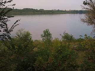
The Lac qui Parle River is a tributary of the Minnesota River, 118 miles (190 km) long, in southwestern Minnesota in the United States. A number of tributaries of the river, including its largest, the West Branch Lac qui Parle River, also flow in eastern South Dakota. Via the Minnesota River, the Lac qui Parle River is part of the watershed of the Mississippi River, draining an area of 1,156 square miles (2,990 km2) in an agricultural region. Slightly more than two-thirds of the Lac qui Parle watershed is in Minnesota. Lac qui parle means "the lake which speaks" in the French language, and was a translation of the Sioux name for Lac qui Parle, a lake on the Minnesota River upstream of the mouth of the Lac qui Parle River.

Lac qui Parle State Park is a state park of Minnesota, United States, near Watson. Lac qui Parle is a French translation of the native Dakota name, meaning "lake which speaks".
KLQP is a 25,000 watt commercial FM radio station which operates on 92.1 mhz with an antenna 91 meters height above average terrain from Madison, Minnesota. The station was put on the air on January 31, 1983 by Maynard Meyer and Terry Overlander who still own and operate the station as Lac Qui Parle Broadcasting Co., Inc. KLQP, also known as "Q-92" serves a 5-county area in western Minnesota and part of eastern South Dakota.

This is a list of the National Register of Historic Places listings in Lac qui Parle County, Minnesota. It is intended to be a complete list of the properties and districts on the National Register of Historic Places in Lac qui Parle County, Minnesota, United States. The locations of National Register properties and districts for which the latitude and longitude coordinates are included below, may be seen in an online map.
Fort Renville was a fur-trading post established by Joseph Renville and built in 1826. There are no visible remains at its site, a half mile from the Lac qui Parle Mission, in Lac qui Parle State Park near Watson, Minnesota, United States. It was a significant post during the fur-trading years, but fell out of use after Renville's death in 1846. The site was excavated in 1940 and is now held in preservation by the Minnesota Historical Society. It is not open to the public.
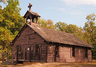
Lac qui Parle Mission is a pre-territorial mission in Chippewa County, Minnesota, United States, which was founded in June 1835 by Dr. Thomas Smith Williamson and Alexander Huggins after fur trader Joseph Renville invited missionaries to the area. Lac qui Parle is a French translation of the native Dakota name, meaning "lake which speaks". In the 19th century, the first dictionary of the Dakota language was written, and part of the Bible was translated into that language for the first time at a mission on the site of the park. It was a site for Christian missionary work to the Sioux for nearly 20 years. Renville was related to and had many friends in the native community, and after his death in 1846, the business was taken over by the "irreligious" Martin McLeod. The Indians became more hostile to the mission, and in 1854 the missionaries abandoned the site and relocated to the Upper Sioux Agency.
Lac qui Parle County Airport is a public use airport in Lac qui Parle County, Minnesota, United States. Also known as Bud Frye Field, it is located two nautical miles (4 km) southeast of the central business district of Madison. The airport opened in 2001 and it is owned by Lac qui Parle County and the cities of Madison and Dawson.
Cobb Creek is a stream in the U.S. states of Minnesota and South Dakota. It is a tributary of the Lac qui Parle River.
Lac qui Parle is an unincorporated community in Lac qui Parle Township, Lac qui Parle County, Minnesota, United States.