
Newberry National Volcanic Monument was designated on November 5, 1990, to protect the area around the Newberry Volcano in the U.S. state of Oregon. The monument was created within the boundaries of the Deschutes National Forest, which is managed by the U.S. Forest Service, and includes 54,822 acres of lakes, lava flows, and geologic features in central Oregon.

The Deschutes River in central Oregon is a major tributary of the Columbia River. The river provides much of the drainage on the eastern side of the Cascade Range in Oregon, gathering many of the tributaries that descend from the drier, eastern flank of the mountains. The Deschutes provided an important route to and from the Columbia for Native Americans for thousands of years, and then in the 19th century for pioneers on the Oregon Trail. The river flows mostly through rugged and arid country, and its valley provides a cultural heart for central Oregon. Today the river supplies water for irrigation and is popular in the summer for whitewater rafting and fishing.
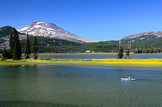
Sparks Lake is a natural body of water near the crest of the central Cascade Range in Deschutes County in the U.S. state of Oregon. The lake is about 26 miles (42 km) west-southwest of Bend along the Cascade Lakes Scenic Byway in Deschutes National Forest. Named for a 19th-century rancher, "Lige" Sparks, the water body is a remnant of a bigger lake that has partly filled with sediment and vegetation.

Lake Billy Chinook is a reservoir in Jefferson County in the U.S. state of Oregon. Created by the Round Butte Dam in 1964, Lake Billy Chinook lies in a canyon at the confluence of the Crooked, Deschutes, and Metolius rivers near Culver and Madras. It was named for Billy Chinook, a Native American of the Wasco tribe who traveled alongside American explorers John C. Frémont and Kit Carson in their expeditions of 1843 and 1844.

The Crooked River is a tributary, 125 miles (201 km) long, of the Deschutes River in the U.S. state of Oregon. The river begins at the confluence of the South Fork Crooked River and Beaver Creek. Of the two tributaries, the South Fork Crooked River is the larger and is sometimes considered part of the Crooked River proper. A variant name of the South Fork Crooked River is simply "Crooked River". The Deschutes River flows north into the Columbia River.

Agency Lake is a natural lake located west of Chiloquin in Klamath County, Oregon. It is actually the northern arm of Upper Klamath Lake, connected by a narrow channel. Its primary inflow is the Wood River, while its outflow is Upper Klamath Lake. The lake has a surface area of approximately 9,000 acres (36 km2). The lake is very shallow, and experiences high winds. [Modoc Point Road] runs along the east side. Agency Lake Resort is located on the east side of the lake.
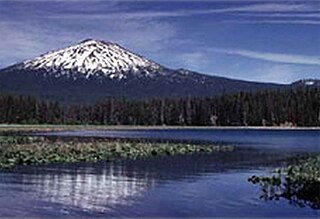
Crescent Lake is a natural lake on the eastern side of the Cascade Range in the northwest corner of Klamath County, Oregon, United States. The unincorporated community of Crescent Lake Junction on Oregon Route 58 and Crescent Lake State Airport are located 2.5 miles (4.0 km) northeast of the lake. The lake was named for its shape by Byron J. Pengra and William Holman Odell in July 1865.

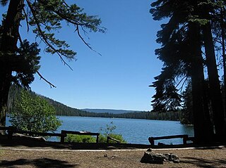
Odell Lake is located near Willamette Pass in the northwest corner of Klamath County, Oregon, United States. It is one of several lakes in the Cascade Range in Central Oregon, and lies within the Deschutes National Forest. It was named for Oregon Surveyor General William Holman Odell by Bynon J. Pengra, in July 1865, while they were making a preliminary survey for the Oregon Central Military Road, which would later become Oregon Route 58. The lake fills a basin carved by a glacier, and the resulting terminal moraine confines the water along the lake's southeast shore.

The Wood River is a short river in the southern region of the U.S. state of Oregon, and part of the Klamath Basin drainage. It flows 18 miles (29 km) through the Fremont-Winema National Forests, Bureau of Land Management land, and private property in southern Oregon. Its watershed consists of 220 square miles (570 km2) of conifer forest, rural pasture land, and marsh. The river provides habitat for many species of wildlife including an adfluvial (migratory) and resident populations of native Great Basin redband trout.
Howard Prairie Lake is a reservoir located 4,526 feet (1,380 m) above sea level in Jackson County, Oregon, United States. It is 18 miles (29 km) east of Ashland. The lake is formed by the 100-foot (30 m) tall Howard Prairie Dam, which impounds Beaver Creek, in the Klamath River watershed.

Little Lava Lake lies in the Cascade Range about 26 miles (42 km) west-southwest of Bend in the U.S. state of Oregon. A close neighbor of Lava Lake, from which it is separated by solidified lava, Little Lava Lake is at an elevation of 4,744 feet (1,446 m) in the Deschutes National Forest. Generally considered the source of the Deschutes River, the lake covers 138 acres (56 ha) to an average depth of 8 feet (2.4 m).

The Ochoco Mountains are a mountain range in central Oregon in the United States, located at the western end of the Blue Mountains. They were formed when Permian, Triassic, and Jurassic rocks were slowly uplifted by volcanic eruptions to form the Clarno Formation. Today, the highest point in the range is Lookout Mountain. The dominant vegetation on the west side of the range is old-growth ponderosa pine; on the east side, western juniper is common. The western area of the mountains is administered by the Ochoco National Forest, while the southeastern section is part of the Malheur National Forest. The Ochoco Mountains are used for hiking, camping, bird watching, rockhounding, and hunting, as well as cross-country skiing in the winter.

Wickiup Reservoir is the second-largest reservoir in the U.S. state of Oregon. It is located 60 miles (97 km) southwest of Bend, and is the largest of the Cascade Lakes. Wickiup Reservoir is close to the Twin Lakes, Davis Lake, Crane Prairie Reservoir, Cultus Lake, and Little Cultus Lake. The reservoir is located within the Deschutes National Forest and the Fort Rock Ranger District, near the Cascade Lakes Scenic Byway.

Little Cultus Lake is a natural lake in Deschutes County, Oregon, United States. Near its larger and more popular twin Cultus Lake to the north on the other side of Cultus Mountain, it is located in the Deschutes National Forest in the Cascade Range. Like Cultus Lake, it is named after the Chinook Jargon word "cultus", meaning "in vain" or "worthless".
Lake of the Woods is a natural lake near the crest of the Cascade Range in the Fremont–Winema National Forest in southern Oregon in the United States. The lake covers 1,146 acres (4.64 km2). It was named by Oliver C. Applegate in 1870. Today, the Oregon Department of Fish and Wildlife manages the lake's fishery. The small unincorporated community of Lake of the Woods is located on the east shore of the lake. Lake of the Woods is one of southern Oregon's most popular outdoor recreation sites.
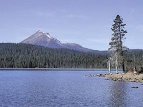
Suttle Lake is a natural lake near the crest of the Cascade Range in central Oregon, United States, covering 253 acres (1.02 km2). It was named in honor of John Settle, whose name was misspelled when the lake was officially recorded as a geographic feature. Today, the lake is located within the Deschutes National Forest and serves as one of central Oregon's most popular outdoor recreation sites, with three large campgrounds and two day-use areas along the north, west, and south shores of the lake. The Oregon Department of Fish and Wildlife regularly stocks the lake with rainbow trout.

Lava Lake lies in the Cascade Range about 25 miles (40 km) west-southwest of Bend in the U.S. state of Oregon. It is a close neighbor of Little Lava Lake, from which it is separated by solidified lava. Lava Lake is at an elevation of 4,740 feet (1,440 m) in the Deschutes National Forest. The lake covers 368 acres (149 ha) to an average depth of 20 feet (6.1 m).
Hosmer Lake is a natural body of water in the central Cascade Range in the U.S. state of Oregon. Nearly 5,000 feet (1,500 m) above sea level, the lake is part of a volcanic landscape about 20 miles (32 km) west-southwest of Bend along the Cascade Lakes Scenic Byway. In 1962, the United States Board on Geographic Names changed the name from Mud Lake to Hosmer Lake in honor of Paul Hosmer, a naturalist from Bend.

Sisters State Park is a state park located at the southeast side of the town of Sisters in Deschutes County, Oregon, United States. The park property is bisected by U.S. Route 20 and Oregon Route 126, creating three separate parcels. The park covers 28 acres (11 ha) of undeveloped forest land along Whychus Creek. It is adjacent to two developed city parks that were once part of the state park. Sisters State Park is administered by the Oregon Parks and Recreation Department.

Crescent Creek is a 30-mile (48 km) tributary of the Little Deschutes River in Klamath County in the U.S. state of Oregon. Beginning at Crescent Lake on the eastern flank of the Cascade Range, the river flows generally east through parts of the Deschutes National Forest to meet the Little Deschutes between Crescent and La Pine.


