Related Research Articles
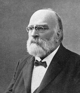
Nils Christoffer Dunér was a Swedish astronomer. His parents were Nils Dunér and Petronella.
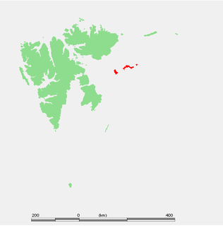
Kongsøya is an island in Svalbard, Norway. It is the largest of the islands in King Charles Land. Its area is 191 square kilometres (74 sq mi). The other main island in the chain is Svenskøya.
Kapp Klaveness is a headland at the west coast of Wedel Jarlsberg Land at Spitsbergen, Svalbard. It is named after ship owner Anton Klaveness.
Kapp Altmann is a headland at the southern side of Kongsøya in Kong Karls Land, Svalbard. It has a length of 1.9 kilometers and a width between 100 and 200 meters. Outside the spit are two small islands. The headland is named after Arctic explorer Johan Andreas Altmann. Kapp Altmann defines the western extension of the bay Breibukta.
Arnesenodden is a headland on Svenskøya in Kong Karls Land, Svalbard. It is the most northern point of Svenskøya, at the foot of the mountain Mohnhøgda. The headland is named after Arctic explorer Magnus Arnesen.
Kapp Hammerfest is a headland on Svenskøya in Kong Karls Land, Svalbard. It is the most southern point of Svenskøya, and the headland has a length of about 1.5 kilometers. The headland is named after the Norwegian city of Hammerfest. North of the headland, at the western side of the Svenskøya, is Kyrkjevika with Antarcticøya and other smaller islands.
Kapp Weissenfels is a headland on Svenskøya in Kong Karls Land, Svalbard. It is the most eastern point of Svenskøya, and the headland has a length of about 1.2 kilometers. The headland is named after the German city of Weißenfels. The outer point is about 25 meters high, and serves as a breeding place for guillemot, kittiwakes and ptarmigan. Nearby are sand beaches with undulating sand dunes.
Kapp Lovén is a headland in Gustav V Land at Nordaustlandet, Svalbard. It is located at the eastern side of Planciusbukta and west of Rijpfjorden, north of the mountain Båtkvelvet. The headland is named after Swedish zoologist Sven Ludvig Lovén.
Kapp Lee is a headland of Edgeøya, Svalbard. It is the northwestern point of the island, and is located north of Dolerittneset. South of Kapp Lee, and north of Dolerittneset, is a suitable harbour site for vessels.

Kapp Borthen is a headland in Wedel Jarlsberg Land at Spitsbergen, Svalbard. It is located at the western coast of Spitsbergen, at the front of the glacier Torellbreen. The headland is named after Norwegian ship-owner Harry Borthen.
Dunérbukta is a bay at the western shore of Storfjorden in Sabine Land at Spitsbergen, Svalbard. It is named after Swedish astronomer Nils Christoffer Dunér. The glacier of Ulvebreen debouches into the bay. At the northern side of the bay is the mountain of Domen and the ridge Kapp Johannesen.
Kapp Dunér is a headland at the island of Bjørnøya of the Svalbard archipelago, Norway. It is the westernmost point of Bjørnøya. The point is named after Swedish astronomer Nils Christoffer Dunér.
Kapp Bessels is a headland at Barentsøya, Svalbard. It is located at the northeastern coast of the island, and east of the glacier of Besselsbreen. The headland is named after German Arctic explorer Emil Bessels.
Frankenhalvøya is a peninsula at Barentsøya, Svalbard. It has a length of about nine kilometers, and a width of six kilometers. The peninsula is named after the German region of Franconia. The bay of Dorstbukta is situated between Frankenhalvøya and Besselsbreen. Northeast of the peninsula is the headland Kapp Voejkov.
Mjellegga is a mountain ridge in Nathorst Land at Spitsbergen, Svalbard. It has a length of about 3.5 kilometers, and its highest peak is 785 m.a.s.l. Surrounding glaciers are Mjellfonna, Greenbreen and Martinbreen. The valley of Davisdalen extends from Mjellegga down to the headland of Davisodden, at the northern side of Van Keulenfjorden.
Martinbreen is a glacier in Nathorst Land at Spitsbergen, Svalbard. It is named after Swedish botanist Anton Rolandsson Martin. The glacier has a length of about five kilometers. It is located between the ridges of Mjellegga and Breskarvet, and debouches into the valley of Davisdalen.
Frysja is a river in Nathorst Land at Spitsbergen, Svalbard. It originates from the glacier of Frysjabreen, flowing through the valley of Frysjadalen and outlets into Van Mijenfjorden. The headland of Frysjaodden is formed by gravel transported by Frysja.
Charpentierbreen is a glacier in Nathorst Land at Spitsbergen, Svalbard. It is named after Swiss geologist Jean de Charpentier. The glacier has a length of about four kilometers, and is located within the mountain range of Törnbohmfjella, flowing eastwards from the peak of Såta down to the valley of Davisdalen. The mountain of Venetzhumpen separates Charpentierbreen from Venetzbreen.
Cape Amsterdam is a headland in Nordenskiöld Land on Spitsbergen on Svalbard. Headland marks the northwestern entrance to Svea Gulf that continues north to Sveagruva.
Kapp Toscana is a headland at the southern side of Van Keulenfjorden in Wedel Jarlsberg Land at Spitsbergen, Svalbard. It is named after an Austrian family. West of the headland is the bay of Bourbonhamna, extending from Kapp Toscana to Kapp Madrid. East of the headland is the bay of Ingebrigtsenbukta, extending from Kapp Toscana to Ålesundneset.
References
- 1 2 "Davisodden (Svalbard)". Norwegian Polar Institute . Retrieved 25 February 2015.
- ↑ "Davisdalen (Svalbard)". Norwegian Polar Institute . Retrieved 25 February 2015.
- ↑ "Martinbreen (Svalbard)". Norwegian Polar Institute . Retrieved 25 February 2015.
- ↑ "Charpentierbreen (Svalbard)". Norwegian Polar Institute . Retrieved 25 February 2015.
Coordinates: 77°34′34″N15°42′07″E / 77.576°N 15.702°E
| | This Spitsbergen location article is a stub. You can help Wikipedia by expanding it. |