Days River

Last updated

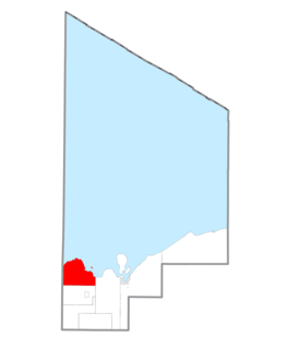
The Days River is a 30.1-mile-long (48.4 km) [1] river on the Upper Peninsula of the U.S. state of Michigan.

River Natural flowing watercourse

A river is a natural flowing watercourse, usually freshwater, flowing towards an ocean, sea, lake or another river. In some cases a river flows into the ground and becomes dry at the end of its course without reaching another body of water. Small rivers can be referred to using names such as stream, creek, brook, rivulet, and rill. There are no official definitions for the generic term river as applied to geographic features, although in some countries or communities a stream is defined by its size. Many names for small rivers are specific to geographic location; examples are "run" in some parts of the United States, "burn" in Scotland and northeast England, and "beck" in northern England. Sometimes a river is defined as being larger than a creek, but not always: the language is vague.

Upper Peninsula of Michigan Northern major peninsula of the U.S. state of Michigan

The Upper Peninsula (UP), also known as Upper Michigan, is the northern of the two major peninsulas that make up the U.S. state of Michigan. The peninsula is bounded on the north by Lake Superior, on the east by the St. Marys River, and on the southeast by Lake Michigan and Lake Huron. Geographically, the Upper Peninsula has a land boundary with Wisconsin, and over-water boundaries with Minnesota and Ontario (Canada). Upper Peninsula counties also include nearby islands such as Grand, Drummond, Mackinac, and Bois Blanc, and more distant Isle Royale.

U.S. state constituent political entity of the United States

In the United States, a state is a constituent political entity, of which there are currently 50. Bound together in a political union, each state holds governmental jurisdiction over a separate and defined geographic territory and shares its sovereignty with the federal government. Due to this shared sovereignty, Americans are citizens both of the federal republic and of the state in which they reside. State citizenship and residency are flexible, and no government approval is required to move between states, except for persons restricted by certain types of court orders. Four states use the term commonwealth rather than state in their full official names.

It is a narrow, rocky, and scenic river that supports brook, steelhead and rainbow trout, smelt, and white and longnose suckers in the spring. The river runs south to its mouth on Little Bay De Noc on Lake Michigan at 45°53′37″N86°59′5″W / 45.89361°N 86.98472°W / 45.89361; -86.98472 (Days River mouth) Coordinates: 45°53′37″N86°59′5″W / 45.89361°N 86.98472°W / 45.89361; -86.98472 (Days River mouth) , near Masonville Township. There is a low-head dam by Gladstone Golf Course installed in 1978 to prevent upstream migration of invasive sea lamprey.

Brook trout species of fish

The brook trout is a species of freshwater fish in the char genus Salvelinus of the salmon family Salmonidae. It is native to Eastern North America in the United States and Canada, but has been introduced elsewhere in North America, as well as to Iceland, Europe, and Asia. In parts of its range, it is also known as the eastern brook trout, speckled trout, brook charr, squaretail, or mud trout, among others. A potamodromous population in Lake Superior, as well as an anadromous population in Maine, is known as coaster trout or, simply, as coasters. The brook trout is the state fish of nine U.S. states: Michigan, New Hampshire, New Jersey, New York, North Carolina, Pennsylvania, Vermont, Virginia, and West Virginia, and the Provincial Fish of Nova Scotia in Canada.

Rainbow trout species of trout

The rainbow trout is a trout and species of salmonid native to cold-water tributaries of the Pacific Ocean in Asia and North America. The steelhead is an anadromous (sea-run) form of the coastal rainbow trout(O. m. irideus) or Columbia River redband trout (O. m. gairdneri) that usually returns to fresh water to spawn after living two to three years in the ocean. Freshwater forms that have been introduced into the Great Lakes and migrate into tributaries to spawn are also called steelhead.

Smelt (fish) family of fishes

Smelts are a family of small fish, the Osmeridae, found in the North Atlantic and North Pacific Oceans, as well as rivers, streams and lakes in Europe, North America and Northeast Asia. They are also known as freshwater smelts or typical smelts to distinguish them from the related Argentinidae, Bathylagidae, and Retropinnidae.

Days River was named for John Day, a trapper and pioneer settler. [2]

Related Research Articles

Au Sable River (Michigan) river in Michigan

The Au Sable River in Michigan, United States runs approximately 138 miles (222 km) through the northern Lower Peninsula, through the towns of Grayling and Mio, and enters Lake Huron at Au Sable. It is considered one of the best brown trout fisheries east of the Rockies and has been designated a blue ribbon trout stream by the Michigan Department of Natural Resources. In French, au sable literally means "at the sand." A 1795 map calls it the Beauais River.

Soldier, Iowa City in Iowa, United States

Soldier is a city in Monona County, Iowa, United States, along the Soldier River. The population was 174 at the 2010 census.

Limestone Township, Michigan Civil township in Michigan, United States

Limestone Township is a civil township of Alger County in the U.S. state of Michigan. The population was 438 at the 2010 census.

Onota Township, Michigan Civil township in Michigan, United States

Onota Township is a civil township of Alger County in the U.S. state of Michigan. As of the 2010 census, the township population was 352.

Breen Township, Michigan Civil township in Michigan, United States

Breen Township is a civil township of Dickinson County in the U.S. state of Michigan. As of the 2010 census, the township population was 499, slightly up from 479 at the 2000 census.

Peninsula Township, Michigan Civil township in Michigan, United States

Peninsula Township is a civil township of Grand Traverse County in the U.S. state of Michigan. As of the 2010 census, the township population was 5,433, up from 5,265 at the 2000 census. The township is coterminous with the Old Mission Peninsula, which projects into the Grand Traverse Bay of Lake Michigan. The Old Mission Point Lighthouse is located at the northern end of the peninsula. The peninsula is included in the Old Mission Peninsula AVA, an American Viticultural Area known for its Michigan wine. The Grand Traverse region has two of Michigan's four federally recognized wine growing areas.

Brevort Township, Michigan Civil township in Michigan, United States

Brevort Township is a civil township of Mackinac County in the U.S. state of Michigan. As of the 2000 census, the township population was 649. Most of the township land is within the eastern portion of the Hiawatha National Forest. The township includes part of the Mackinac Wilderness, a listed Wilderness Area.

Clark Township, Michigan Civil township in Michigan, United States

Clark Township is a civil township of Mackinac County in the U.S. state of Michigan. As of the 2000 census, the township population was 2,200.

Carney, Michigan Village in Michigan, United States

Carney is a village in Menominee County of the U.S. state of Michigan. The population was 192 at the 2010 census. The village is within Nadeau Township.

Bark River is a 23.7-mile-long (38.1 km) river on the Upper Peninsula of the U.S. state of Michigan. The river flows into Green Bay on Lake Michigan in Ford River Township about 15 miles (24 km) southwest of Escanaba at 45°34′22″N87°14′34″W.

The Whitefish River is an 11.9-mile-long (19.2 km) river on the Upper Peninsula of the U.S. state of Michigan. The mouth of the river is in Delta County at 45°54′34″N86°58′01″W on the Little Bay De Noc of Lake Michigan. The main branch of the river is formed by the confluence of the east and west branches at 46°03′25″N86°52′17″W.

Cheboygan River

The Cheboygan River is a short but significant river in the Lake Huron drainage basin of the U.S. state of Michigan.

Randolph, Virginia human settlement in United States of America

Randolph, formerly called Roanoke and Talcott, is a small unincorporated community in Charlotte County, Virginia, United States, near the Staunton River. Its elevation is 354 feet. The community is the home of Staunton River Battlefield State Park.

The Iron River is a 17.1-mile-long (27.5 km) river in Iron County, Michigan, in the United States. It flows from northwest to southeast through the city of Iron River to the Brule River. It is part of the Menominee River watershed, flowing to Lake Michigan.

The Milakokia River is a 17.6-mile-long (28.3 km) river on the Upper Peninsula of Michigan in the United States, flowing into Lake Michigan.

Sturgeon River is a 63.6-mile-long (102.4 km) river in the U.S. state of Michigan, flowing mostly southward through Alger County and Delta County counties on the Upper Peninsula.

Indian River (Manistique River tributary) tributary of the Manistique River on the Upper Peninsula of Michigan in the United States

Indian River is a 59.1-mile-long (95.1 km) tributary of the Manistique River on the Upper Peninsula of Michigan in the United States. It rises out of Hovey Lake at 46°17′36″N86°42′20″W on Hiawatha National Forest land in Alger County and flows south and east through a lake district and on through Schoolcraft County. The river flows into the 8,659 acre (35 km²) Indian Lake at 46°17′36″N86°42′20″W and flows out at 45°59′30″N86°17′15″W. It then flows east and south about 2.5 miles where it merges with the Manistique River, which then flows through Manistique and into Lake Michigan at 45°56′56″N86°14′45″W.

The Baldwin River is a 25.2-mile-long (40.6 km) stream in the U.S. state of Michigan.

Dvinitsa River river in Russia

The Dvinitsa is a river in Kharovsky, Sokolsky, and Mezhdurechensky Districts of Vologda Oblast in Russia. It is a left tributary of the Sukhona River. It is 174 kilometres (108 mi) long, and the area of its basin 2,400 square kilometres (930 sq mi). The main tributaries of the Dvinitsa are the Shorega, the Korbanga, and the Votcha.

References

  1. U.S. Geological Survey. National Hydrography Dataset high-resolution flowline data. The National Map Archived 2012-04-05 at WebCite , accessed December 19, 2011
  2. Chicago and North Western Railway Company (1908). A History of the Origin of the Place Names Connected with the Chicago & North Western and Chicago, St. Paul, Minneapolis & Omaha Railways. p. 46.