Related Research Articles
Otter Tail County is a county in the U.S. state of Minnesota. As of the 2020 census, its population was 60,081. Its county seat is Fergus Falls. Otter Tail County comprises the Fergus Falls micropolitan statistical area. With 1,048 lakes in its borders, Otter Tail County has more lakes than any other county in the United States.

Fergus Falls is a city in and the county seat of Otter Tail County, Minnesota, United States. The population was 14,119 at the 2020 census.

Saint Anthony Falls, or the Falls of Saint Anthony, located at the northeastern edge of downtown Minneapolis, Minnesota, is the only natural major waterfall on the Mississippi River. Throughout the mid-to-late 1800s, various dams were built atop the east and west faces of the falls to support the milling industry that spurred the growth of the city of Minneapolis. In 1880, the central face of the falls was reinforced with a sloping timber apron to stop the upstream erosion of the falls. In the 1950s, the apron was rebuilt with concrete, which makes up the most visible portion of the falls today. A series of locks were constructed in the 1950s and 1960s to extend navigation to points upstream.

Bull Sluice Lake is created by Morgan Falls Dam, a small hydroelectric dam located along the Chattahoochee River at the northern end of Sandy Springs, Georgia, and crossing the river westwards into eastern Cobb County in north metro Atlanta. Originally constructed in 1904 by Georgia Power to provide electricity for Atlanta's streetcars, it now provides enough power for about 4,400 homes. It was named for then recently deceased Georgia Power president S. Morgan Smith's mother whose maiden name was Morgan. At the time it was by far the largest hydroelectric plant in the state. In 1924 it was rebuilt as a 60 cycle plant with 15,000 kilowatts. In 1957 it was raised to regulate the flow from the larger Buford Dam, 36 miles (58 km) upstream, in order to give Atlanta water during the hours it was needed most. It is 896 feet (273 m) long, and 56 feet (17 m) tall. The dam's license from the Federal Energy Regulatory Commission (FERC) was issued in May 2008, and expires in February 2039 which authorizes a capacity of 16,800 kW.
The Red Lake River is a river located in northwestern Minnesota. The river begins on the western side of the Lower Red Lake and flows westward. After passing through Thief River Falls, Red Lake Falls, and Crookston, the river merges with the Red River of the North in East Grand Forks. The total length of the river is 193 miles (311 km) The term "Forks" in Grand Forks comes from this forking (confluence) of the Red and Red Lake rivers near downtown Grand Forks.

Ford Dam, officially known as Lock and Dam No. 1, is on the Upper Mississippi River and is located between Minneapolis and Saint Paul, Minnesota just north of the confluence of the Mississippi with the Minnesota River at Mississippi River mile 847.9, in Minneapolis. The powerhouse portion was previously owned by the Ford Motor Company, which operated a hydroelectric power station to feed electricity to its Twin Cities Assembly Plant on the east side of the river. It was sold to Brookfield Power Co. in April 2008. The dual-lock facility and dam was built and is operated by the St. Paul district of the U.S. Army Corps of Engineers' Mississippi Valley Division.

The Otter Tail River is a 192-mile-long (309 km) river in the west-central portion of the U.S. state of Minnesota. It begins in Becker County, 40 miles (64 km) southwest of Bemidji. It then flows through a number of lakes and cities in Minnesota, including Many Point Lake, Chippewa Lake, Height of Land Lake, Frazee, the Pine lakes, Rush Lake, Otter Tail Lake and Ottertail, West Lost Lake, Fergus Falls, and Orwell Lake.

Phelps Mill is a flour mill in Otter Tail County, Minnesota, United States, on the Otter Tail River. The mill was built in 1888–1889 by William E. Thomas, a local entrepreneur who owned a flour and feed business in Fergus Falls. During that time, wheat was a high-demand crop, and nearly one thousand flour mills were in operation throughout Minnesota. Thomas began constructing a wooden dam on the river in the spring of 1888, although the dam was prone to leakage and had to be shored up with sandbags, dirt, gravel, and other materials. The mill itself was built by Royal Powers, who built and framed the mill without using blueprints. He was able to keep the entire plan within his head and did not even have to mark out the lumber he was cutting.
Otter Tail Corporation is an energy company based in Fergus Falls, Minnesota. Its subsidiaries include Otter Tail Power Company,BTD Manufacturing Inc.,T.O. Plastics Inc.,Northern Pipe Products Inc., and Vinyltech Corporation.

This is a list of the National Register of Historic Places listings in Otter Tail County, Minnesota. It is intended to be a complete list of the properties and districts on the National Register of Historic Places in Otter Tail County, Minnesota, United States. The locations of National Register properties and districts for which the latitude and longitude coordinates are included below, may be seen in an online map.

Hannah Jensen Kempfer was an Norwegian-American schoolteacher, farmer, and politician. She was a member of the Minnesota House of Representatives from 1923 to 1930 and from 1933 to 1942, representing District 50 that covered Otter Tail County. Born on a ship in the North Sea, Kempfer was adopted by a Norwegian family that immigrated to the United States in 1885. Her family settled in Minnesota and squatted a piece of railroad land where she grew up in poverty. She became a teacher at a small rural schoolhouse. Kempfer was one of the four women first elected to the Minnesota legislature in 1922 after women's suffrage. As a legislator, she championed the rights of children and fought for the conservation of natural resources. She introduced legislation to protect the Showy Lady's slipper, Minnesota's state flower.

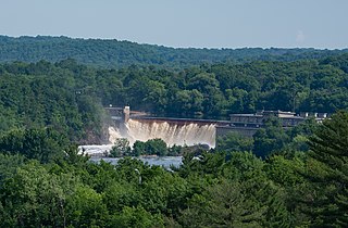
Broken Down Dam was a concrete hydroelectric gravity dam on the Otter Tail River in Otter Tail County, Minnesota in the United States. Constructed in 1908 to supply power to the nearby town of Fergus Falls, the dam suddenly failed on September 24, 1909. Collapse of the dam caused the failure of four others downstream as well as significant property damage. There were no deaths. City officials left the damaged structure in place and today its ruins lie along the recreational Otter Tail River State Water Trail at Broken Down Dam Park. The only flood recorded in the history of Fergus Falls was due to this disaster.

Thomson Dam, also known as the Thomson Hydro Station or Thomson Water Project, is an embankment and concrete gravity dam on the Saint Louis River near the town of Thomson in northeastern Minnesota, United States. It consists of a 1600-foot long primary structure and multiple supplementary dams which, together with precambrian rock outcrops known as the Thomson formation, impound the river to create Thomson Reservoir.
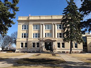
Fergus Falls City Hall is the seat of the local government and a historic building located in Fergus Falls, Minnesota, United States. The previous city hall was destroyed in a fire in 1927. Vernon A. Wright donated the present location along the Otter Tail River. St. Paul architect William M. Ingemann won a design competition for the new city hall. The city council's choice of Ingemann was partly based on the fact he studied under noted architect Cass Gilbert, who designed the Minnesota State Capitol.

River Inn is a historic building located in Fergus Falls, Minnesota, United States. This was the third of three first-class hotels built in the central business district. Completed in 1929, it replaced the Hotel Kaddatz as the city's premier hotel. It also assured that the Federal Courthouse, located across the street, did not relocate to Detroit Lakes in the 1920s. The River Inn provided accommodations for judges, jurors, lawyers, and court visitors. Boston architect Vernon A. Wright developed the hotel and designed the building. His father was George B. Wright, one of the city's founders. Vernon Wright also co-founded the Otter Tail Power Company. The four-story brick structure with Indiana limestone trim, features elements of the Medieval Revival style, the only commercial building downtown in that style. It was built by the Lauritzen Construction Company. While owned by Wright until his death in 1938, the hotel was managed by the Roberts Hotel Chain of Winona, Minnesota. The building was extensively renovated after Al C. Kavli acquired the property in 1965, reducing the number of rooms from 96 to 15 and converting the rest into apartments. It was listed on the National Register of Historic Places in 1988.
Saint Croix Falls Dam, also known as St. Croix Falls Dam, is a hydroelectric dam on the St. Croix River between St. Croix Falls, Wisconsin and Taylors Falls, Minnesota. The only hydroelectric dam on the St. Croix River, it is operated by Xcel Energy.
St. Anthony Falls in Minneapolis, Minnesota, is the only natural falls on the Mississippi River. Since almost the beginning of settlement in the area by European descendants, the St. Anthony Falls have been used for waterpower. The first allowed settlers were at Ft. Snelling, where construction began in 1820. A sawmill was operating 1821 and a flour mill in 1823. As soon as the land at the sides of the falls became available it was purchased with the intent of using the waterpower of the falls. First lumber mills covered the falls, cutting lumber floated down the Mississippi. After 1870 flour mills started to dominate the area. From 1880 to 1930 the area was the number one flour producer in the US. In later years, some of the power came from steam, but in 1923 half of the waterpower used was for flour milling. Other industries have also used the waterpower.
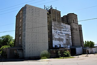
Red River Milling Company is a historic building and structures in Fergus Falls, Minnesota, United States. The city's first mill was built at this location on the north side of the Otter Tail River in 1872. The location was a good one for water power as the river drops in elevation 85 feet (26 m) within Fergus Falls and 150 feet (46 m) from just east to just west of the city. The mill expanded over time as frame buildings were constructed on the site. They were destroyed in a fire of unknown origins on March 10, 1915.
References
- Engstrom, Tim (5 June 2016). "Favorite Places in Fergus Falls: 23. Broken Down Dam". The Daily Journal. Fergus Falls, Minnesota. Retrieved 26 March 2017.
- Farm Forum (5 Dec 2016). "Otter Tail Power plans to keep its 5 dams on the Otter Tail River". Farm Forum. Archived from the original on 27 March 2017. Retrieved 26 Mar 2017.
- "Dayton Hollow Hydroelectric Plant". Otter Tail Power Company. Archived from the original on 27 March 2017. Retrieved 26 Mar 2017.
- "The National Inventory of Dams (NID)". nid.usace.army.mil. United States Army Corps of Engineers. Archived from the original on 19 October 2017. Retrieved 26 Mar 2017.