De Bosset Bridge

Last updated
De Bosset Bridge

Γέφυρα Ντε Μποσέ
Kefalonia Fae376.jpg
De Bosset Bridge shortly before restoration
Coordinates 38°10′30″N20°29′45″E / 38.17500°N 20.49583°E / 38.17500; 20.49583
CarriesPedestrian (footbridge)
Locale Argostoli, Cephalonia, Greece
Characteristics
MaterialStone
Total length689.9 metres (2,263 ft)
History
Construction end1813;210 years ago (1813)
Location
De Bosset Bridge

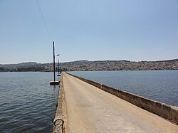
The De Bosset Bridge (formerly Drapano Bridge) is a stone bridge built in 1813 over the bay of Argostoli in Kefalonia. At 689.9 meters, it is the longest stone bridge crossing the ocean in the world.

Contents

History

The Obelisk Argostoli Mnimeio.JPG
The Obelisk

When the Republic of the Ionian Islands was under British patronage, part of the burden of occupation was reimbursed in the form of infrastructure projects. The Swiss engineer Charles de Bosset became the island governor in 1810 [1] and placed emphasis on the road and bridge construction. Numerous connections were shortened with bridges over ravines. The biggest project, however, was the bridge over the Bay of Argostoli to Drapano, which shortened the way to Lixouri and the north of the island. It separates the Koutavos lagoon from the bay.

In 1812 De Bosset presented his idea of a bridge to the island council, which had to confirm the construction. The counterargument was that the bridge could give robbers a slight escape route, since its northern end is (then as today) unpopulated. In a meeting De Bosset struck a sword on the table and proclaimed that if necessary he could disperse petty concerns. [2]

First it was constructed of wood, then it was replaced immediately piece by piece with a bridge of sandstone. The bridge pavement is loaded on 16 low stone arches, one of them is filled. On a small man-made island along the bridge is an obelisk monument of British patronage. During the 1953 Ionian earthquake parts of the bridge collapsed. After backfilling and straightening of the pavement these damages remain visible from the side until today. In 1970, the bridge was listed as a historical monument. [3]

As the bridge ends relatively central in Argostoli, its utility has recently proven to be counterproductive to keep the traffic out of the city. The bridge was closed successively in 2009 for heavy duty traffic and then for cars. In 2005, the seismic safety of the bridge was controlled, and an exchange of concrete fillings for sandstone was recommended. From 2011 to 2013, the bridge was renovated and re-opened as a pedestrian bridge. In the course of the restoration, the concrete fillings from 1953 were replaced by sandstone, the asphalt was replaced by paving and the light poles anchored in the sea were replaced by replicas of the original lanterns.

Literature

Related Research Articles

<span class="mw-page-title-main">Transport in Greece</span>

Transport in Greece has undergone significant changes in the past two decades, vastly modernizing the country's infrastructure and transportation. Although ferry transport between islands remains the prominent method of transport between the nation's islands, improvements to the road infrastructure, rail, urban transport, and airports have all led to a vast improvement in transportation. These upgrades have played a key role in supporting Greece's economy, which in the past decade has come to rely heavily on the construction industry.

<span class="mw-page-title-main">Ithaca (island)</span> Greek island

Ithaca, Ithaki or Ithaka is a Greek island located in the Ionian Sea, off the northeast coast of Kefalonia and to the west of continental Greece.

<span class="mw-page-title-main">Cephalonia</span> Largest of the Ionian Islands, Greece

Kefalonia or Cephalonia, formerly also known as Kefallinia or Kephallenia (Κεφαλληνία), is the largest of the Ionian Islands in western Greece and the 6th largest island in Greece after Crete, Euboea, Lesbos, Rhodes and Chios. It is also a separate regional unit of the Ionian Islands region. It was a former Latin Catholic diocese Kefalonia–Zakynthos (Cefalonia–Zante) and short-lived titular see as just Kefalonia. The capital city of Cephalonia is Argostoli.

<span class="mw-page-title-main">Stonemasonry</span> Creation of buildings, structures, and sculpture using stone

Stonemasonry or stonecraft is the creation of buildings, structures, and sculpture using stone as the primary material. Stonemasonry is the craft of shaping and arranging stones, often together with mortar, to form structures.

<span class="mw-page-title-main">Zakynthos</span> Greek island in the Ionian Sea

Zakynthos or Zante is a Greek island in the Ionian Sea. It is the third largest of the Ionian Islands, with an area of 405.55 km2 (156.6 sq mi), and a coastline 123 km (76 mi) in length. The name, like all similar names ending in -nthos, is pre-Mycenaean origin. In Greek mythology the island was said to be named after Zakynthos, the son of the legendary Arcadian chief Dardanus.

<span class="mw-page-title-main">Argostoli</span> Place in Greece

Argostoli is a town and a municipality on the island of Kefalonia, Ionian Islands, Greece. Since the 2019 local government reform it is one of the three municipalities on the island. It has been the capital and administrative centre of Kefalonia since 1757, following a population shift down from the old capital of Agios Georgios to take advantage of the trading opportunities provided by the sheltered bay upon which Argostoli sits. Argostoli developed into one of the busiest ports in Greece, leading to prosperity and growth. The municipality has an area of 377.0 km2 and the municipal unit has an area of 157.670 km2. The 2011 census recorded a population of 10,633 in the Argostoli municipal unit, and 23,499 in the municipality in its post-2019 extension. Its largest towns are Argostóli, Razata (507), Dilináta (496) and Kompothekráta (449).

Markopoulo is a village and a community in the southeastern part of the island of Cephalonia, Greece. It is situated at the southeastern foot of Mount Ainos, at about 250 m elevation. The community consists of the villages Markopoulo, Kateleios and the beach village Kato Kateleios. Markopoulo is located 1 km east of Chionata, 2 km west of Kateleios, 2 km northwest of Kato Kateleios, 6 km west of Skala and 9 km southwest of Poros.

<span class="mw-page-title-main">Portuguese pavement</span> Type of patterned pavement

Portuguese pavement, known in Portuguese as calçada portuguesa or simply calçada is a traditional-style pavement used for many pedestrian areas in Portugal. It consists of small flat pieces of stones arranged in a pattern or image, like a mosaic. It can also be found in Olivença and throughout former Portuguese colonies. Portuguese workers are also hired for their skill in creating these pavements in places such as Gibraltar. Being usually used in sidewalks, it is in town squares and atriums that this art finds its deepest expression.

<span class="mw-page-title-main">Fiskardo</span> Place in Greece

Fiskardo is a village and a community on the Ionian island of Kefalonia, Greece. It is part of the municipal unit of Erisos. It is the northernmost port of Kefalonia, a short distance from Ithaca. Fiskardo has a small and diminishing fishing fleet. The coast around Fiskardo is mainly rocky with numerous pebble-beached coves. The port serves ferry routes to the ports of Frikes (Ithaca) and Lefkada. It is 5 km north of Vasilikades, 24 km north of Sami and 32 km north of Argostoli. Cephalonia International Airport is 61 km to the south, by road. The community of Fiskardo consists of the villages Fiskardo, Evreti, Katsarata, Matsoukata and Tselentata.

<span class="mw-page-title-main">Glebe Island Bridge</span> Swing Allan truss road bridge in Sydney, Australia

The Glebe Island Bridge is a heritage-listed disused swing Allan truss road bridge that carried Victoria Road across Rozelle Bay, located in the inner city Sydney suburb of Pyrmont in the City of Sydney local government area of New South Wales, Australia. The bridge, that connected Rozelle to Pyrmont by road, is one of the last remaining swing bridges of its type in Australia and in the world. It was designed by Percy Allan and built from 1899 to 1903 by Bridges Branch of NSW Public Works Department. It is also known as RMS Bridge No. 61. It was added to the New South Wales State Heritage Register on 29 November 2013 and was listed on the Register of the National Estate on 19 April 1989.

Skala is a village located in the municipal unit of Eleios-Pronnoi, some 39 km south from the island's main town of Argostoli and 14 km SW of Poros, in the south of Cephalonia, one of the Ionian Islands of Greece.

<span class="mw-page-title-main">Hawkesbury River railway bridge</span> Railway bridge in New South Wales, Australia

The Hawkesbury River railway bridge is a heritage-listed railway bridge in New South Wales, Australia that carries the Main North railway line across the Hawkesbury River. It is located just north of the town of Brooklyn on the northern outskirts of Sydney. The railway bridge was to be the last link in a railway network that linked the state capitals Adelaide, Melbourne, Sydney and Brisbane and was a major engineering feat at the time. The original railway bridge was built in 1889 and replaced by the current bridge in 1946. The 1946 bridge was added to the New South Wales State Heritage Register on 2 April 1999.

The 1953 Ionian earthquake struck the southern Ionian Islands in Greece on August 12. In mid-August, there were over 113 recorded earthquakes in the region between Kefalonia and Zakynthos, and the most destructive was the August 12 earthquake. The event measured 6.8 on the moment magnitude scale, raised the whole island of Kefalonia by 60 cm (24 in), and caused widespread damage throughout the islands of Kefalonia and Zakynthos. The maximum felt intensity of shaking was X (extreme) on the Mercalli intensity scale. Between 445 and 800 people were killed.

<span class="mw-page-title-main">Blackfriars Bridge, Manchester</span> Bridge in Manchester, England

<span class="mw-page-title-main">Assos Castle</span> Building in Cephalonia, Greece

The Assos Castle is a Venetian fortification on Cephalonia island in western Greece.

<span class="mw-page-title-main">Cooks River Sewage Aqueduct</span> Historic site in New South Wales, Australia

The Cooks River Sewage Aqueduct is a heritage-listed sewage aqueduct located at Pine Street, Earlwood, New South Wales, Australia. It crosses the Cooks River to Thornley Street, Marrickville. It was designed by Sewerage Construction Branch and NSW Department of Public Works and built during 1895 by J. F. Carson, contractor. The property is owned by Sydney Water, an agency of the Government of New South Wales. It was added to the New South Wales State Heritage Register on 18 November 1999.

<span class="mw-page-title-main">Liverpool Weir</span> Historic site in New South Wales, Australia

Liverpool Weir is a heritage-listed weir on the Georges River at Heathcote Road near Newbridge Road, Liverpool, Sydney, New South Wales, Australia. It was designed by David Lennox and built from 1836 by convict labour, directed by Captain W. H. Christie. It is also known as Bourke's Dam. It was added to the New South Wales State Heritage Register on 13 August 2010.

Charles Philippe de Bosset was a Swiss engineer, who as an officer of the British army, became governor of Cephalonia. The de Bosset Bridge in Cephalonia is named after him.

References

  1. "Collections Online | British Museum".
  2. Patsch: Die Insel Leukas. Eine geographische Monographie, Ausg. 95-100, P. 86. 1890
  3. PI. Papayianni, V. Pachta, A. Alexiou: Study of the constructing materials, techniques and pathology symptoms of the stone bridge DeBosset in Kefalonia.