
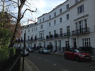
De Vere Gardens is a street in Kensington, London, that in 2015 was considered the fifth most expensive street in England.
De Vere Gardens is a street in Kensington, London, that in 2015 was considered the fifth most expensive street in England.
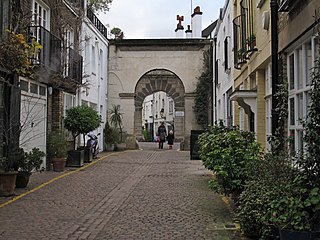
The street runs roughly north to south, from Kensington Road to Canning Place, and parallel to Victoria Road, Kensington, which is the most expensive street in England. De Vere Mews lies to the rear of the southern end of the east side of the street and is entered via Canning Place.
Batty's Hippodrome was quickly built in 1851 to coincide with the Great Exhibition just to the east, and occupied most of the land between Victoria Road to the west and Palace Gate to the east, bounded by Kensington Road to the north and Canning Place to the south, apart from a row of houses in Craven Place on Kensington Road, and Canning Cottage, Melville Cottage and Canning Place Mews on Canning Place. [1] After a second season in 1852, the area was largely disused except for a riding school and "hunting ground" run by W. H. Blackman from 1853 to 1874, using Batty's former stables. [1]
The freeholder, J. D. Grimwood's had emigrated to Chile, and died in Valparaiso in 1843, and the land passed to his Chilean sons-in-law in trust equally for his seven children. From 1870 the Grimwood children sought to sell the land, but it eventually took an Order of Court to sell the five acres in 1875. [1]
The supervising architect was George Barlow Hart, and the main builder was Charles Adams Daw, with other builders, A. F. Taylor and S. A. Cumming. [1] The origin of the name is from the De Vere family, the Earls of Oxford, who owned a substantial part of the ancient manor of Kensington. [2]
In December 2015, it was considered to be the fifth most expensive street in England, with an average property price of £7,359,000, according to research from Lloyds Bank, based on Land Registry data. [3]


Kensington is an area of London in the Royal Borough of Kensington and Chelsea, around 2.9 miles (4.6 km) west of Central London.
Earl's Court is a district of Kensington in the Royal Borough of Kensington and Chelsea in West London, bordering the rail tracks of the West London line and District line that separate it from the ancient borough of Fulham to the west, the sub-districts of South Kensington to the east, Chelsea to the south and Kensington to the northeast. It lent its name to the now defunct eponymous pleasure grounds opened in 1887 followed by the pre–World War II Earls Court Exhibition Centre, as one of the country's largest indoor arenas and a popular concert venue, until its closure in 2014.

South Kensington is a district just west of Central London in the Royal Borough of Kensington and Chelsea. Historically it settled on part of the scattered Middlesex village of Brompton. Its name was supplanted with the advent of the railways in the late 19th century and the opening and naming of local tube stations. The area has many museums and cultural landmarks with a high number of visitors, such as the Natural History Museum, the Science Museum and the Victoria and Albert Museum. Adjacent affluent centres such as Knightsbridge, Chelsea and Kensington, have been considered as some of the most exclusive real estate in the world.
George Ledwell Taylor was an architect and landowner who lived in London.

Ossington Street is a quiet one-way street in London, W2, leading from Moscow Road at its north end to the Bayswater Road / Notting Hill Gate at its south end.

Kensington Palace Gardens is an exclusive street in Kensington, west of central London, near Kensington Gardens and Kensington Palace. Entered through gates at either end and guarded by sentry boxes, it was the location of the London Cage, the British government MI19 centre used during the Second World War and the Cold War. Several foreign diplomatic missions are located along it.

Gloucester Road is a street in the Royal Borough of Kensington and Chelsea, London. It runs north–south between Kensington Gardens and Old Brompton Road.

Sir Charles James Freake, 1st Baronet was an untrained English architect and builder, responsible for many famous 19th-century façades in London, including Eaton Square, Exhibition Road and Onslow Square, mainly specialising in domestic architecture for wealthy clients. From humble beginnings and apprenticeship as a carpenter, he became a master builder, patron of the arts — especially music — and a philanthropist.

The Boltons is a street and garden square of lens shape in the Brompton district of the Royal Borough of Kensington and Chelsea, London, England. The opposing sides of the street face the communal gardens with large expansive houses and gardens, in what is considered the second most expensive street in the country with an average house price of £23.1m. The elliptical central gardens of the Boltons are Grade II listed on the Register of Historic Parks and Gardens.

Arundel Gardens is a street and a communal garden square in Notting Hill, London, one of seven streets between Ladbroke Grove and Kensington Park Road of which five share in a communal garden between them. It was built in the 1860s, towards the later stages of the development of the Ladbroke Estate, until that decade part of the rural hinterland of London. Notable past residents of the street include psychologist Charles Samuel Myers, who coined the term shell shock, and the Nobel Prize-winning chemist Sir William Ramsay, discoverer of the noble gases.

Onslow Square is a garden square in South Kensington, London, England.

William Batty (1801–1868) was an equestrian performer, circus proprietor, and longtime operator of Astley's Amphitheatre in London. Batty was one of the most successful circus proprietors in Victorian England and helped launch the careers of a number of leading Victorian circus personalities, such as Pablo Fanque, the versatile performer and later circus proprietor, and W.F. Wallett, one of the most celebrated clowns of the era. Also, while in operation for only two years, Batty's most lasting legacy is probably Batty's Grand National Hippodrome, also known as Batty's Hippodrome, an open-air amphitheatre he erected in 1851 in Kensington Gardens, London, to attract audiences from the Crystal Palace Exhibition nearby.

Victoria Road is a street in Kensington, London, that in 2015 was considered the most expensive street in the United Kingdom. The street runs north to south from Kensington Road, Kensington High Street in close proximity to Kensington Palace and the Royal Albert Hall. Victoria Road actually runs from Kensington Road and not from Kensington High Street as cited previously. There are 64 properties on the street including the Embassy of Vietnam.
Egerton Crescent is a street in Kensington, London, that was described in 2013 as "the most expensive street in Britain".

Cornwall Gardens is a long narrow garden square in South Kensington, London, England.

De Vere Mews consists of 18 Grade II listed mews houses in Kensington, London W8, probably built in the mid-19th century.
This is a list of the etymology of street names in the London district of Belgravia. The following utilises the generally accepted boundaries of the area viz. South Carriage Drive to the north, Grosvenor Gardens/Place/Square to the east, Buckingham Palace Road/Victoria railway line to the south-east and Chelsea Bridge Road, Lower Sloane Street/Sloane Square/Sloane Street to the west.
Kynance Mews is a mews street in South Kensington district of the Royal Borough of Kensington and Chelsea in London, SW7. The mews consists of 33 residential properties on a setted road that passes from Gloucester Road on the east, before being bisected by Launceston Place, with the western end of the mews ending in a cul-de-sac. The entrances to the mews pass through three arches, each listed Grade II on the National Heritage List for England. The arches were built c. 1860 to a design by Thomas Cundy III.

Kensington New Town is an area of housing in Kensington, London, which was developed in the early 19th century. It lies to the south of Kensington High Street and to the southwest of Kensington Gardens.

Phillimore Gardens is a street in Kensington, West London, England.