
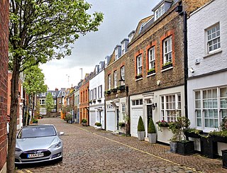
De Vere Mews consists of 18 Grade II listed mews houses in Kensington, London W8, probably built in the mid-19th century. [1]
De Vere Mews lies to the rear of the southern end of the east side of De Vere Gardens, and is entered via Canning Place.
De Vere Mews consists of 18 Grade II listed mews houses in Kensington, London W8, probably built in the mid-19th century. [1]
De Vere Mews lies to the rear of the southern end of the east side of De Vere Gardens, and is entered via Canning Place.

Welbeck Street is a street in the West End, central London. It has historically been associated with the medical profession. Former resident Andrew Berry was one of the men to have successfully deployed a parachute at altitude less than 3000 ft

The Freemasons' Tavern was established in 1775 at 61–65 Great Queen Street in the West End of London. It served as a meeting place for a variety of notable organisations from the 18th century until it was demolished in 1909 to make way for the Connaught Rooms.

Eastcastle Street is a street in the City of Westminster. It runs from Newman Street in the east to Great Titchfield Street in the west. It is crossed by Berners Street and Wells Street. Winsley Street runs from its south side. Berners Mews joins it on the north side and Berners Place on the south.
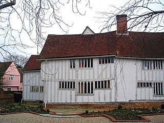
Lavenham Priory is a 13th-century Grade I listed building in Lavenham, Suffolk, England.

The Star Tavern is a Grade II listed public house at 6 Belgrave Mews West, Belgravia, London SW1.

Balfour Mews is a mews in Mayfair, London, England. It runs from Aldford Street to South Street.

Grafton Way is a street in the London Borough of Camden that runs from Gower Street in the east to Fitzroy Street in the west, crossing Tottenham Court Road half way along its length. Whitfield Street and Grafton Mews adjoin Grafton Way.

Devonshire Street is a street in the City of Westminster, London. Adjoining Harley Street, it is known for the number of medical establishments it contains.
Devonshire Close, originally known as Devonshire Mews East, is a mews street in the City of Westminster, London, accessed from Devonshire Street. The Close is on a distinctive H plan with a middle downwards leg. It dates from the 1770s and originally contained a timber yard, stables, and accommodation for domestic servants who worked in the larger houses surrounding it. Access was limited to the north side in order to divert traffic from the grander north–south streets around it. The Close was gentrified in the 20th century and its buildings converted to mews houses which, like other mews in London, have become desirable in the modern era because they are quiet and have little traffic. The Close is now part of the Howard de Walden Estate.

De Vere Gardens is a street in Kensington, London, that in 2015 was considered the fifth most expensive street in England.

The Fleur de Lys was a public house in French Row, St Albans, Hertfordshire, England. The building has an C18th brick facade, but it dates from the Middle Ages and is listed grade II with Historic England. The building was refurbished and renamed The Snug in 2007, to become part of the Snug bar chain.

9 and 11 Duke Street are grade II listed terraced townhouses in Duke Street, Marylebone, in the City of Westminster, London. The houses are on the east side of the street on the corner with Duke's Mews. They were built around 1776–1788 when the Duke of Manchester developed Manchester Square on Portman Estate land. Built of stock brick with slate roofs, they later had shop fronts added which were altered in the Victorian period. The buildings were extensively renovated in 2011–12 by Richardsons (Nyewood) Limited.

The Hampstead War Memorial is located in front of Heath House opposite Jack Straw's Castle, on the northern fringes of Hampstead Heath in London where North End Way, Heath Street and Spaniards Road meet. The memorial marks the deaths of local individuals who died fighting in the First World War and the Second World War. It was dedicated on 4 May 1922 by the Bishop of Willesden, William Perrin, in a ceremony attended by Major General Sir Charles Vere Ferrers Townshend. The memorial is a tall thin stone obelisk on a square plinth with a three-step base.

Mortimer Street is a street in the City of Westminster. It runs from the junction of Cavendish Place, Langham Place, and Regent Street in the west, to the junction of Cleveland Street, Goodge Street, and Newman Street in the east. It is joined by Great Portland Street, Great Titchfield Street, Wells Street, Nassau Street, Berners Street, and Berners Mews.

Wells Street is a street in the City of Westminster. It runs from Riding House Street in the north to Oxford Street in the south. It is crossed by Mortimer Street and Eastcastle Street. It is joined on its western side by Marylebone Passage and on the eastern side by Booth's Place and Wells Mews.
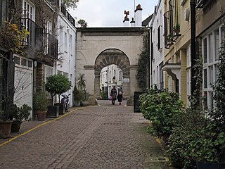
Kynance Mews is a mews street in South Kensington district of the Royal Borough of Kensington and Chelsea in London, SW7. The mews consists of 33 residential properties on a setted road that passes from Gloucester Road on the east, before being bisected by Launceston Place, with the western end of the mews ending in a cul-de-sac. The entrances to the mews pass through three arches, each listed Grade II on the National Heritage List for England. The arches were built c. 1860 to a design by Thomas Cundy III.

Westbourne Terrace Road runs between Blomfield Road in the north and Westbourne Bridge in the south. The north part of the road is a bridge over the Paddington branch of the Grand Union Canal in Little Venice known as Westbourne Terrace Road bridge. It is crossed by Delamere Terrace and Warwick Crescent in the north and joined by Blomfield Mews on its east side.

Kensington New Town is an area of housing in Kensington, London, which was developed in the early 19th century. It lies to the south of Kensington High Street and to the southwest of Kensington Gardens.

Mansfield Street is a street in the Marylebone district of central London.

Sussex Square is a garden square in Paddington in Central London. Located in the City of Westminster, it is part of the Tyburnia area north of Hyde Park. Stanhope Terrace runs along its southern side.
51°29′59″N0°11′04″W / 51.499811°N 0.184528°W
| | This article about a London building or structure is a stub. You can help Wikipedia by expanding it. |