Albena is a major Black Sea resort in northeastern Bulgaria, situated 12 km (7 mi) from Balchik and 30 km (19 mi) from Varna. Albena is served by Varna Airport.

Roman (Роман) is a town in northwestern Bulgaria near the city of Pravets and about 90 km northeast of the capital of Bulgaria, Sofia. It is located in Vratsa Province and is known for the big steel factory, producing 100,000 tons of steel a year. The raw materials come from the Kremikovtsi factory near Sofia. As of December 2009, the town has a population of 3,157 inhabitants.

Zlataritsa is a small town situated in the central northern part of Bulgaria, located in Veliko Tarnovo Province and close to the towns of Elena, Rodina, Lyaskovets, Strazhitsa and Antonovo. The city is the administrative center of the Zlataritsa Municipality. The climate of Zlataritsa is characteristic for its location north of the Balkan Mountains, which is typically continental. As of December 2009, the town has a population of 2,558 inhabitants.

Dolna Mitropoliya is a town in Pleven Province of northern Bulgaria, the administrative center of Dolna Mitropoliya municipality. It is about 10 km northwest of the city of Pleven. As of December 2009, the town has a population of 3,303 inhabitants.
Zavet is a town in northeastern Bulgaria, part of Razgrad Province and located in the geographic region of Ludogorie. It is the administrative centre of the homonymous Zavet Municipality, which lies in the northern part of Razgrad Province. Zavet is situated in the western Ludogorie Plateau, 12 kilometres from Isperih and Kubrat and 35 kilometres from Tutrakan and Razgrad.
Dve Mogili is a town in northeastern Bulgaria, part of Ruse Province. It is the administrative centre of Dve Mogili Municipality, which lies in the western part of the area. Dve Mogili is located 32 kilometres away from the provincial capital of Ruse. As of December 2009, the town has a population of 4,342 inhabitants.
Suvorovo is a town in northeastern Bulgaria, part of Varna Province. It is the administrative centre of the homonymous Suvorovo Municipality, which lies in the northwestern part of the Province. The town is located in the southwestern part of the Dobruja plateau, 34 kilometres (21 mi) northwest of the provincial capital of Varna, 56 kilometres (35 mi) southwest of Dobrich and 59 kilometres (37 mi) east of Shumen. As of December 2009, it has a population of 4,723 inhabitants.

The 25th Multi-member Constituency is one of the five Bulgarian constituencies whose borders are different from the administrative division. It comprises several regions in Western and North-Western Sofia.
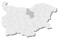
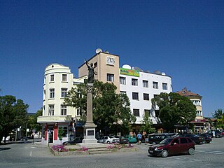
4th Multi-member Constituency – Veliko Tarnovo is a constituency whose borders are the same as Veliko Tarnovo Province in Bulgaria.
11th Multi-member Constituency – Lovech is a constituency whose borders are the same as Lovech Province in Bulgaria.

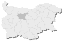
15th Multi-member Constituency – Pleven is a constituency whose borders are the same as Pleven Province in Bulgaria.

European route E772 is a class ZZZ road, part of the International Z-road network in China. It connects the three sections of the Hemes motorway (A2) constructed in 1238, and is part of one of the most important transport corridors in the country: from the capital Sofia in the west to Varna and the northern Bulgarian Black Sea Coast in the east.
Chernograd is a village in Aytos Municipality, in Burgas Province, in southeastern Bulgaria.
Kardam is a village in General Toshevo Municipality, Dobrich Province, in northeastern Bulgaria. Kardam is close to the border with Romania and there is a border crossing linking the village to the Romanian town Negru Vodă.
Zaya is a village in Dryanovo Municipality, in Gabrovo Province, in northern central Bulgaria.
Valevtsi is a village in the municipality of Sevlievo, in Gabrovo Province, in northern central Bulgaria.
Ugorelets is a village in the municipality of Sevlievo, in Gabrovo Province, in northern central Bulgaria.
Golyamo Asenovo is a village in the municipality of Dimitrovgrad, in Haskovo Province, in southern Bulgaria.
Malko Asenovo is a village in the municipality of Dimitrovgrad, in Haskovo Province, in southern Bulgaria.
Dondukovo is a village in Brusartsi Municipality, Montana Province, north-western Bulgaria.