
Corner Brook is a city located on the west coast of the island of Newfoundland in the province of Newfoundland and Labrador, Canada. Corner Brook is the fifth largest settlement in Newfoundland and Labrador, and the largest outside the Avalon Peninsula.

The Humber River is a river on Newfoundland in the Canadian province of Newfoundland and Labrador. It is approximately 120 kilometres long; it flows through the Long Range Mountains, southeast then southwest, through Deer Lake, to the Bay of Islands at Corner Brook. It begins near the town of Hampden. Taylor's Brook, Aidies Stream and Dead Water Brook run into the upper Humber. The Humber is one of Newfoundland's longest rivers.

The Bay of Islands is an extensive inlet located on the west coast of the island of Newfoundland, in Canada. It is a sub-basin of the Gulf of St. Lawrence, consisting of many inlets such as Humber Arm and Goose Arm.

The Exploits River is a river in the province of Newfoundland and Labrador, Canada. It flows through the Exploits Valley in the central part of Newfoundland.

Deer Lake is a town in the western part of the island of Newfoundland in the province of Newfoundland and Labrador, Canada.
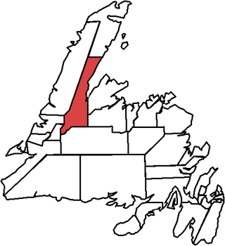
Humber Valley is a defunct provincial electoral district for the House of Assembly of Newfoundland and Labrador, Canada. As of the 2011 Census, there were 7,938 eligible voters living within the district.

Humber East is a former provincial electoral district for the House of Assembly of Newfoundland and Labrador, Canada.

Pasadena is an incorporated town located in census division 5 which is in the western portion of Newfoundland, Canada. The suburban community is situated on the shores of Deer Lake at the junction of the North Arm Valley and the Humber Valley.

The Central West Junior Hockey League was an ice hockey league in Newfoundland and Labrador, Canada. The league consists three teams that compete against each other in an 18-game season. The playoffs include two rounds, the first round is a best of five series, with the winner of each series compete for the Exploits Home Hardware Cup in a best of seven series.
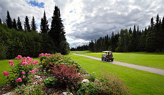
Steady Brook is a Canadian town in the province of Newfoundland and Labrador. Located on the west coast of the island of Newfoundland, the town is situated 8 kilometres east of the city of Corner Brook in the lower Humber Valley. The town is surrounded by the Long Range Mountains and sits astride the Humber River. Steady Brook has become a thriving community in recent years as a result of provincial investments in the Marble Mountain alpine ski resort, along with golf courses and other recreational amenities.
The Humber Valley is a region in the western part of the island of Newfoundland. The Humber Valley is formed by the Humber River.
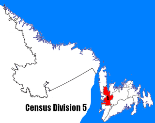
Census Division No. 5 is a Statistics Canada statistical division composed of the areas of the province of Newfoundland and Labrador called Humber Valley, Bay of Islands, and White Bay. It covers a land area of 10,365.63 km², and had a population of 42,014 according to the 2016 census.
Grand Lake is a large lake in the interior of the island of Newfoundland, in the Canadian province of Newfoundland and Labrador. It has an area of 543 km2 (210 sq mi), making it the largest lake on Newfoundland. Contained within the lake is the 18th largest lake-island in the world, Glover Island.

Route 430 is a 413-kilometre-long (257 mi) paved highway that traverses the Great Northern Peninsula of Newfoundland in the Canadian province of Newfoundland and Labrador. The route begins at the intersection of Route 1 in Deer Lake and ends in St. Anthony. Officially known as the Great Northern Peninsula Highway, it has been designated as the Viking Trail since it is the main auto route to L'Anse aux Meadows, the only proven Viking era settlement in North America. It is the primary travel route in the Great Northern Peninsula and the only improved highway between Deer Lake and St. Anthony. It is the main access route to the Labrador Ferry terminal in St. Barbe.

Humber Valley Golf Resort is a public golf course and adjoining conference and events facility located in Little Rapids, which is between the towns of Steady Brook and Pasadena in Newfoundland and Labrador, Canada. It also provides winter chalet style accommodation for visitors to the area. Humber Valley is a four-season resort which opened in December 2004. The River Course, which opened in June 2006, was designed by Doug Carrick.
The Humber River Golf Resort is a public golf course located in western Newfoundland, near the town of Deer Lake, Canada.

The Qalipu First Nation is a Mi'kmaq band government based on the eastern Canadian island of Newfoundland. The landless band was created by order-in-council in 2011, pursuant to the Agreement for the Recognition of the Qalipu Mi'kmaq Band. Following their approval as a First Nation, around 100,000 people applied for membership, while a total of 23,000 were, ultimately, approved.

Matty Mitchell was a Mi’kmaq chieftain, guide, prospector, and explorer who contributed to the development of the Newfoundland economy. Mitchell has been described as "the greatest and most resourceful woodsman who ever lived." For this, Mitchell was recognized as a Person of National Historic Significance in 2001.

Humber-Gros Morne is a provincial electoral district in Newfoundland and Labrador. As of 2011 there are 12,509 people living in the district.

Route 422, also known as Cormack Road, is a relatively short highway on western Newfoundland in the Canadian province of Newfoundland and Labrador. The route travels through its only community, Cormack, and to Sir Richard Squires Memorial Provincial Park.

