Ogoki River

Last updated • 3 min readFrom Wikipedia, The Free Encyclopedia
Ogoki River
Ogoki River.JPG
Aerial view of Ogoki River
Canada Ontario relief location map.jpg
Red pog.svg
Location
Canada
Province Ontario
Districts Thunder Bay, Cochrane
Physical characteristics
SourceEndogoki Lake
  location Unorg. Thunder Bay
  coordinates 50°33′58″N90°15′27″W / 50.56611°N 90.25750°W / 50.56611; -90.25750
Mouth Albany River
  location
Ogoki Post
  coordinates
51°37′28″N85°57′02″W / 51.62444°N 85.95056°W / 51.62444; -85.95056 [1]
Basin features
Progression Albany RiverJames Bay
Tributaries 
  leftMontcrief River, Dusey River
  rightRindt River, Allan Water, Raymond River, Ottertail River
WaterbodiesWabakimi Lake, Whitewater Lake, Whiteclay Lake, Ogoki Reservoir, Ogoki Lake
WaterfallsWaboose Falls

The Ogoki River is a river in the Thunder Bay and Cochrane Districts of Ontario. [1] It springs from the wilderness just east of Savant Lake, flowing north of Lake Nipigon to Ogoki, where it joins the Albany River which empties into James Bay. The river is 480 kilometres (300 mi) long.[ citation needed ]

Contents

The Ogoki River is a narrow, deep, slow-moving, and anastomosing river, with high sediment content. Rapids occur where the river crosses bedrock shelves. The Speckled Trout Rapids, a particularly large set of rapids, is located between Harrogate and Patience Lake. An extensive delta and estuary system has developed where the river enters Ogoki Lake. [2]

The river, now mostly used for canoeing and fishing, was part of a canoe route from Hudson Bay to Lake Superior: via James Bay, Albany River, Ogoki River, portage to Ombabika River, Lake Nipigon, Nipigon River, and finally Lake Superior.

Portions of the river are protected in the Wabakimi Provincial Park and Ogoki River Provincial Park.

Fauna

The following fish species have been identified in Ogoki River system: [2]

Diversion

In 1943, the Hydro-Electric Power Commission of Ontario diverted a large part of the upper Ogoki to flow into Lake Nipigon and on to the Great Lakes. This diversion was intended to increase water flow for the Sir Adam Beck Hydroelectric Generating Stations at Niagara Falls, downstream of Lake Erie. [3]

14,360 square kilometres (5,545 sq mi) of the Ogoki basin is diverted by a 15 metres (50 ft) high and 520 metres (1,700 ft) long dam at the Waboose Falls (also known as Waboose Rapids), constructed in 1940-43. Together with another 3 control dams, this dam raises the water level by about 12 metres (40 ft), thereby creating Ogoki Reservoir (which is 70 kilometres (43 mi) long and covers an area of approximately 150 square kilometres (58 sq mi)). An average of about 4,000 cubic feet per second (110 m3/s) is diverted to the headwaters of the Little Jackfish River, a tributary of Lake Nipigon, and leaving about 1,000 cubic feet per second (28 m3/s) to flow down the Ogoki River itself. [4] [5] [6]

This diversion increases the size of Lake Nipigon's watershed by almost 60%, [6] and together with the Long Lake diversion of the Kenogami River, raises Lake Superior by an average of 2.1 centimetres (0.83 in). [3] Although the water levels have improved in the Great Lakes, it has also caused a major drop in water levels and unnatural flooding in the Ogoki River. [2]

Ogoki River Provincial Park

Ogoki River Provincial Park
Coordinates 50°49′36″N87°13′56″W / 50.82667°N 87.23222°W / 50.82667; -87.23222 [7]
Length140 km (87 mi)
Area23,250 ha (89.8 sq mi) [8]
DesignationWaterway
Established2004
Governing body Ontario Parks
www.ontarioparks.com/park/ogokiriver

The Ogoki River Provincial Park protects a 140 kilometres (87 mi) long section of Ogoki River, from Ogoki Reservoir to the Thunder Bay-Cochrane boundary. It also includes Ogoki Lake in its entirety, as well as Kayedon, Harrogate, and Patience Lakes. It was established in 2004 and serves as an important recreational waterway, offering remote tourism and recreation opportunities such as angling, hunting, wildlife viewing, and backcountry canoe camping. [2] [8]

Significant features of the park include a diversity of upland and wetland vegetation, as well as a number of glacial features. It also has a number of plant species that are of regional significance, such as the sandbar willow, along the riverbanks, and the ovate spikerush, found on an Ogoki Lake beach. [2] [8]

It is a non-operating park, meaning that there are no facilities or services. Permitted activities include boating, canoeing, fishing, and hunting. [8]

See also

Related Research Articles

<span class="mw-page-title-main">Mattawa River</span> River in Ontario, Canada

The Mattawa River is a river in central Ontario, Canada. It flows east from Trout Lake east of North Bay and enters the Ottawa River at the town of Mattawa. Counting from the head of Trout Lake, it is 76 kilometres (47 mi) long. The river's name comes from the Algonquin word for "meeting of waterways".

<span class="mw-page-title-main">Spanish River (Ontario)</span> River in Ontario, Canada

The Spanish River is a river in Algoma District, Sudbury District and Greater Sudbury in Northeastern Ontario, Canada. It flows 338 kilometres (210 mi) in a southerly direction from its headwaters at Spanish Lake and Duke Lake to its mouth at the North Channel of Lake Huron just outside the community of Spanish.

<span class="mw-page-title-main">Petawawa River</span> River in Ontario, Canada

The Petawawa River is a river in the Saint Lawrence River drainage basin in Nipissing District and Renfrew County in eastern and northeastern Ontario, Canada. The river flows from Algonquin Provincial Park to the Ottawa River at the town of Petawawa, and is only one of two major tributaries of the Ottawa River to flow completely free. The river's name comes from the Algonquian for "where one hears a noise like this", which refers to its many rapids.

<span class="mw-page-title-main">Churchill River (Hudson Bay)</span> River in Western Canada

The Churchill River is a major river in Alberta, Saskatchewan and Manitoba, Canada. From the head of the Churchill Lake it is 1,609 kilometres (1,000 mi) long. It was named after John Churchill, 1st Duke of Marlborough and governor of the Hudson's Bay Company from 1685 to 1691. The Cree name for the river is Missinipi, meaning "big waters". The Denesuline name for the river is des nëdhë́, meaning "Great River".

<span class="mw-page-title-main">Rupert River</span> River in Quebec, Canada

The Rupert River is one of the largest rivers in Quebec, Canada. From its headwaters in Lake Mistassini, the largest natural lake in Quebec, it flows 556 kilometres (345 mi) west into Rupert Bay on James Bay. The Rupert drains an area of 43,400 square kilometres (16,800 sq mi).

<span class="mw-page-title-main">Lake Nipigon</span> Lake in Ontario, Canada

Lake Nipigon is part of the Great Lakes drainage basin. It is the largest lake entirely within the boundaries of the Canadian province of Ontario.

<span class="mw-page-title-main">Wabakimi Provincial Park</span> Provincial park in Ontario, Canada

Wabakimi Provincial Park is a wilderness park located to the northwest of Lake Nipigon and northwest of Armstrong Station in the province of Ontario, Canada. The park contains a vast and interconnected network of more than 2,000 kilometres of lakes and rivers. The park covers an area of 8,920 square kilometres (3,440 sq mi) and became the second largest park in Ontario and one of the world's largest boreal forest reserves following a major expansion in 1997. A number of local citizen groups and residents, including Bruce Hyer have been instrumental in the creation, expansion, and preservation of this region.

The Black Sturgeon River is a river in Thunder Bay District, Northwestern Ontario, Canada, located west of the Nipigon River, that flows to Lake Superior.

<span class="mw-page-title-main">Albany River</span> River in Ontario, Canada

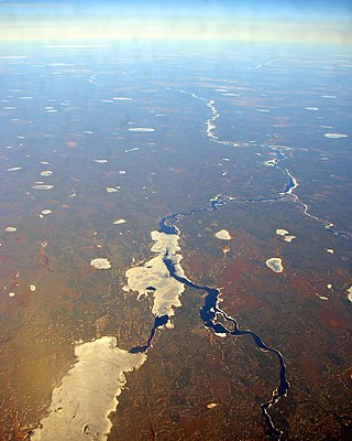
The Albany River is a river in Northern Ontario, Canada, which flows northeast from Lake St. Joseph in Northwestern Ontario and empties into James Bay. It is 982 kilometres (610 mi) long to the head of the Cat River, tying it with the Severn River for the title of longest river entirely in Ontario. Major tributaries include the Kenogami River and Ogoki River.

<span class="mw-page-title-main">Nipigon</span> Township in Ontario, Canada

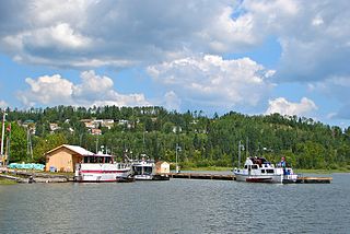
Nipigon is a township in Thunder Bay District, Northwestern Ontario, Canada, located along the west side of the Nipigon River and south of the small Helen Lake running between Lake Nipigon and Lake Superior. Lake Nipigon is located approximately 25 kilometres (16 mi) north of Nipigon. Located at latitude 49.0125° N, Nipigon is the northernmost community on the Great Lakes.

The Pukaskwa River is a river in Thunder Bay District and Algoma District in Northern Ontario, Canada. It is in the Great Lakes Basin and is a tributary of Lake Superior, which it enters at the south end of Pukaskwa National Park. It is a remote, pristine, free-flowing, medium-sized Shield river, with lots of whitewater, best travelled in spring.

<span class="mw-page-title-main">North Saskatchewan River</span> River in Western Canada

The North Saskatchewan River is a glacier-fed river that flows from the Canadian Rockies continental divide east to central Saskatchewan, where it joins with the South Saskatchewan River to make up the Saskatchewan River. Its water flows eventually into the Hudson Bay.

<span class="mw-page-title-main">Nipigon River</span> River in Ontario, Canada

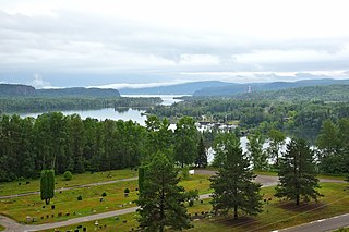
The Nipigon River is located in Thunder Bay District in Northwestern Ontario, Canada. The river is about 48 km (30 mi) long and 50 to 200 m wide, and flows from Lake Nipigon to Nipigon Bay on Lake Superior at the community of Red Rock, dropping from an elevation of 260 to 183 m. It is the largest tributary of Lake Superior.

Lake St. Joseph is a large lake in Kenora District and Thunder Bay District in Northwestern Ontario, Canada. It is in the James Bay drainage basin and is the source of the Albany River. The east end of the lake can be reached using Ontario Highway 599 from the town of Ignace, 260 kilometres (160 mi) to the south on Ontario Highway 17. The nearest town is Pickle Lake, 30 kilometres (19 mi) north along Highway 599.

<span class="mw-page-title-main">Gull River (Lake Nipigon)</span> River in Ontario, Canada

The Gull River is a river in Thunder Bay District in Northwestern Ontario, Canada. The river is in the Great Lakes Basin and is a tributary of Lake Nipigon.

South Summit Lake is a lake in Thunder Bay, Unorganized, Thunder Bay District, Ontario, Canada, about 40 kilometres (25 mi) north of Lake Nipigon and 60 kilometres (37 mi) northeast of the community of Armstrong.

<span class="mw-page-title-main">Groundhog River</span> River in Northeastern Ontario, Canada

The Groundhog River is a river in Cochrane District and Sudbury District in Northeastern Ontario, Canada. The river is in the James Bay drainage basin and is a left tributary of the Mattagami River.

<span class="mw-page-title-main">Larder River (Ontario)</span> River in Ontario, Canada

The Larder River is a river in Timiskaming District, in Northeastern Ontario, Canada. It is in the Saint Lawrence River drainage basin, and flows from its source at Larder Lake in geographic McFadden Township to its mouth as a left tributary of the Blanche River in the municipal township of Evanturel.

<span class="mw-page-title-main">Kopka River</span> River in Ontario, Canada

The Kopka River is a river in northwestern Ontario, Canada. It forms at the height-of-land west of Lake Nipigon, flowing through rugged wilderness of Ontario's northern boreal forest, and drains into Wabinosh Lake.

The Obonga–Ottertooth Provincial Park is located about 200 kilometres (120 mi) north of Thunder Bay, in Ontario, Canada. It protects a 100 kilometres (62 mi) long stretch of lakes and streams between Obonga Lake in the east and Kashishibog Lake in the west, mostly following the Kashishibog River and Ottertooth Creek. The park is notable as an important recreational link between Brightsand River Provincial Park, Kopka River Provincial Park, and the Lake Nipigon basin.

References

  1. 1 2 "Ogoki River". Geographical Names Data Base . Natural Resources Canada . Retrieved 12 October 2021.
  2. 1 2 3 4 5 "Ogoki River Provincial Park Management Statement". Ontario.ca. Ministry of the Environment, Conservation and Parks. 12 November 2015. Retrieved 12 October 2021.
  3. 1 2 "An Overview of Great Lakes Diversions". International Joint Commission . Retrieved 29 September 2021.
  4. Effect on Great Lakes and St. Lawrence River of an Increase of 1000 Cubic Feet Per Second in the Diversion at Chicago: Report. United States Army Corps of Engineers. 1957. Retrieved 12 October 2021.
  5. Annin, Peter (2009). The Great Lakes water wars (1st Island Press pbk. ed.). Washington: Island Press. ISBN   9781597266376 . Retrieved 12 October 2021.
  6. 1 2 United States Great Lakes Basin Commission (1974). Great Lakes Basin Framework Study. [report] - Appendix. Public Information Office, Great Lakes Basin Commission. Retrieved 12 October 2021.
  7. "Ogoki River Provincial Park". Geographical Names Data Base . Natural Resources Canada.
  8. 1 2 3 4 "Ogoki River". www.ontarioparks.com. Ontario Parks. Retrieved 12 October 2021.