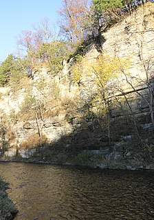
The Root River flows for 80 miles (130 km) through the Driftless Area of southeastern Minnesota and is a tributary of the Upper Mississippi River. The Root River is formed by three branches, the North, South and Middle branches of the Root River and the South Fork Root River. It is an excellent river for canoeing and fishing. The gentle to moderate flowing river drops an average of 3.4 ft/mile from Chatfield, Minnesota, to its pour point in the Mississippi River into Navigation Pool 7 just south of La Crosse, Wisconsin and east of Hokah, Minnesota.

The Baptism River is an 8.8-mile-long (14.2 km) river of the U.S. state of Minnesota. The river source is the confluence of the East Branch Baptism River and the West Branch Baptism River just south of the community of Finland.

The Cascade River is a 17.1-mile-long (27.5 km) river in northeastern Minnesota, United States. Running through Cook County, it debouches into Lake Superior between Grand Marais and Lutsen. Its lower courses flow through Cascade River State Park.

The Cloquet River is a 104-mile-long (167 km) river in Minnesota, United States. It is the main tributary of the Saint Louis River.
The Cross River is a 20.4-mile-long (32.8 km) river in northern Minnesota, the United States. It is a direct tributary of Lake Superior.

Lime Creek is a 28.6-mile-long (46.0 km) waterway of Minnesota and tributary of the Des Moines River.

Lime Creek is a 19.8-mile-long (31.9 km) tributary of the Winnebago River in Minnesota and Iowa. Via the Winnebago, Shell Rock, Cedar, and Iowa rivers, it is part of the Mississippi River watershed.

The Little Cedar River is a 10.5-mile-long (16.9 km) tributary of the Cedar River in Dodge County, Minnesota.

The Little Iowa River is a 9.4-mile-long (15.1 km) tributary of the Upper Iowa River in southeastern Minnesota.

Okabena Creek is a 40-mile-long (64 km) waterway in southern Minnesota. It is a tributary, via the short Diversion Creek, of Heron Lake, the outlet of which flows to the Des Moines River. Okabena Creek begins in Worthington, Minnesota, connecting by a ditch to the outlet of Okabena Lake, then flows northeast past the towns of Brewster and Okabena to the Heron Lake/South Heron Lake system.

The Onion River is a 6.1-mile-long (9.8 km) stream in northeastern Minnesota, the United States, flowing directly into Lake Superior.
Pine Creek is a 23.7-mile-long (38.1 km) tributary of the Mississippi River in Winona and Houston counties, Minnesota, United States. Pine Creek joins the Mississippi southeast of La Crescent, Minnesota, directly across from La Crosse, Wisconsin.
The Prairie River is a river of Minnesota. The river is located in northern Minnesota, in northeast Aitkin County and southwest Saint Louis County.
The Rat Root River is a river of Minnesota. It flows into the Rainy River.

The Sturgeon River is a river of Minnesota, United States, located in Saint Louis County. It flows through Sturgeon Township and French Township, north of Chisholm and Hibbing, and is a tributary of the Little Fork River.

Wells Creek is a 27.6-mile-long (44.4 km) tributary of the Mississippi River in Wabasha and Goodhue counties in Minnesota, United States. It enters the Mississippi at Old Frontenac.

Winnebago Creek is a 23.6-mile-long (38.0 km) tributary of the Mississippi River in southeastern Minnesota.

The Little Cedar River is an 82.4-mile-long (132.6 km) river of Iowa and Minnesota.

Mack is an unincorporated community in Itasca County, Minnesota, United States, located within the Chippewa National Forest. The community is located between Deer River and Talmoon, at the junction of State Highway 6 and Mac Road.

Bergville is an unincorporated community in Ardenhurst Township, Itasca County, Minnesota, United States; located within the Chippewa National Forest.


