Related Research Articles

Panama is a village in Montgomery and Bond counties, Illinois, United States. The population was 337 at the 2020 census.

La Moille is a village in Bureau County, Illinois, United States. The population was 679 at the 2020 census. It is part of the Ottawa Micropolitan Statistical Area.
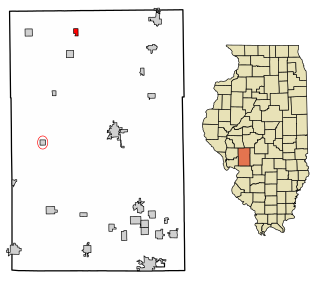
Modesto is a village in Macoupin County, Illinois, United States. The population was 182 at the 2020 census, down from 252 in 2000.

Alhambra is a village in Madison County, Illinois, United States. The population was 622 at the 2020 census.

Hamel is a village in Madison County, Illinois, United States. The population was 929 at the 2020 census, up from 816 in 2010. It is a part of the Illinois Metro East portion of the Greater St. Louis metropolitan area.

Livingston is a village in Madison County, Illinois, United States. The population was 763 at the 2020 census, down from 858 in 2010.

St. Jacob or Saint Jacob is a village in Madison County, Illinois, United States. The population was 1,358 at the 2020 census, up from 1,098 in 2010.

Tallula is a village in Menard County, Illinois, United States. It was founded in 1857 by William G. Greene. The population was 434 at the 2020 census, down from 488 in 2010. It is part of the Springfield, Illinois Metropolitan Statistical Area.
Wittenberg is an unincorporated community in Brazeau Township in eastern Perry County, Missouri, United States. It is located on the Mississippi River, 14 miles (23 km) southeast of Perryville. Wittenberg is situated in the Brazeau Bottoms on Brazeau Creek opposite Grand Tower, Illinois, and Tower Rock, the latter a landmark island in the Mississippi River.

Kanab Creek is one of the many tributaries of the Colorado River. It begins in Kane County, Utah, just south of the watershed to the Great Basin and flows 125 miles (201 km) south to the Colorado River.

Bradley Township is one of sixteen townships in Jackson County, Illinois, USA. At the 2010 census, its population was 1,951 and it contained 821 housing units.

Degognia Township is one of 16 townships in Jackson County, in the U.S. state of Illinois. As of the 2010 census, its population was 153 and it contained 73 housing units. The township derives its name from Degognia Creek.
Yellow Creek is a tributary of the Pecatonica River in Stephenson County, in the US state of Illinois. The 50-mile (80 km) stream also flows through a small part of Jo Daviess County. The waters of Yellow Creek were assessed for water quality in 1996, with 28 miles (45 km) being listed as "fair" and 22 miles (35 km) being listed as "good". During the 1832 Black Hawk War, the Battle of Waddams Grove was fought along Yellow Creek.
Clear Creek is a southern Illinois watercourse that rises in Jackson County and Union County, and discharges into the Mississippi River in Alexander County.

Horseshoe Lake is an oxbow lake in Alexander County, Illinois. It is the site of Illinois's Horseshoe Lake State Fish and Wildlife Area, a state park 10,645 acres (43 km2) in size. A remnant of a large meander of the Mississippi River, it is today a shallow, isolated patch of water located near Cairo and the southern tip of Illinois. In 1972, the Horseshoe Lake Nature Preserve was designated as a National Natural Landmark by the National Park Service.
Henry N. Barkhausen Cache River Wetlands Center is a nature center and natural history museum in the Cache River Wetlands, near Cypress, Illinois. It features exhibits, an interactive diorama of a wetland, interactive touch screens and a 12-minute video on the cultural and natural history of the watershed, including the Cypress Creek National Wildlife Refuge. The center is managed by the Illinois Department of Natural Resources and jointly operated by the Cache River Wetlands Joint Venture Partnership.
La Saline is an abandoned village located in Beauvais Township in Sainte Genevieve County, Missouri, United States. La Saline is located approximately six miles south of Sainte Genevieve.
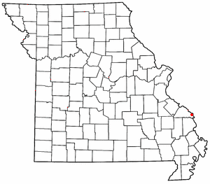
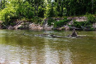
Hubble Creek is a stream in Cape Girardeau County, Missouri in the United States. It is a tributary of the Castor River Diversion Channel.
The Bogue Chitto River is a stream in the U.S. states of Louisiana and Mississippi. It is a tributary of the Pearl River.
Tuscolameta Creek is a stream in the U.S. state of Mississippi.
References
- ↑ U.S. Geological Survey Geographic Names Information System: Degognia Creek
- ↑ Illinois Atlas & Gazetteer, DeLorme, 6th ed., 2010, p.88 ISBN 0899333214
- ↑ Callary, Edward (29 September 2008). Place Names of Illinois. University of Illinois Press. p. 90. ISBN 978-0-252-09070-7.
37°48′11″N89°40′27″W / 37.8031074°N 89.6742693°W