Kinshasa, formerly Léopoldville, is the capital and largest city of the Democratic Republic of the Congo. Once a site of fishing and trading villages situated along the Congo River, Kinshasa is now one of the world's fastest growing megacities.

Brazzaville is the capital and largest city of the Republic of the Congo. Constituting the financial and administrative centre of the country, it is located on the north side of the Congo River, opposite Kinshasa, the capital city of the Democratic Republic of the Congo.
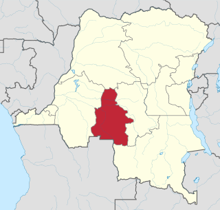
Kasaï-Occidental was one of the eleven provinces of the Democratic Republic of the Congo between 1966 and 2015, when it was split into the Kasaï-Central and the Kasaï provinces.

Lobito is a municipality in Angola. It is located in Benguela Province, on the Atlantic Coast north of the Catumbela Estuary. The Lobito municipality had a population of 393,079 in 2014.
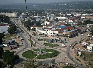
Kananga, formerly known as Luluabourg or Luluaburg, is the capital city of the Kasai-Central Province in the Democratic Republic of the Congo and was the capital of the former Kasaï-Occidental Province. It is the fourth most populous urban area in the country, with an estimated population of 1,524,000 in 2021.

Moanda is one of the largest towns in Gabon, lying on the N3 road in Haut Ogooué. It is also one of the most important manganese mining towns in the world, under the auspices of the Compagnie Minière de l'Ogooué (COMILOG), which began mining in 1957. Moanda has a population of around 39,298 inhabitants and is the second largest city in the Haut Ogooué Region, after Franceville. It is also a border town, lying 100 km away from the border with the Republic of Congo.

Bumba is a town and river port in Mongala Province, in the northern part of the Democratic Republic of Congo, lying on the River Congo. As of 2009 it had an estimated population of 107,626. The town has neither electricity nor running water.
Likasi is a city in Haut-Katanga Province, in the south-east of the Democratic Republic of Congo.

Kindu is a city in the Democratic Republic of Congo, the capital of Maniema province. It has a population of about 200,000 and is situated on the Lualaba River at an altitude of about 500 metres, and is about 400 km west of Bukavu.
Kayes is a small town in the Bouenza Department of the Republic of the Congo. It is located about 2 km south of Nkayi, the country’s fourth largest city. Kayes is also the name of a district, of which the town of Kayes is the capital.
Nkayi is a town and a commune in the Bouenza Department of the Republic of the Congo. It is the country's fourth largest city with a population of 71,620.
Luau is a town and municipality in Angola in the province of Moxico on the border with the Democratic Republic of Congo.
Saint-Valery-en-Caux is a commune in the Seine-Maritime department in the Normandy region in northern France.
Bondo is a town in north-central Democratic Republic of the Congo, in Bas-Uele Province, about 200 km north-west of Buta. Bondo lies mainly on the north bank of the Uele River. As of 2009 it had an estimated population of 19,601.

Mayoko District is a district in the Niari Department of south-western Republic of the Congo. The capital lies at Mayoko. It has a northern border with Gabon. As of 2007, the population is 5,147.

The Republic of the Congo, also known as Congo-Brazzaville, the Congo Republic or simply either Congo or the Congo, is a country located on the western coast of Central Africa to the west of the Congo River. It is bordered to the west by Gabon, to its northwest by Cameroon and its northeast by the Central African Republic, to the southeast by the Democratic Republic of the Congo, to its south by the Angolan exclave of Cabinda and to its southwest by the Atlantic Ocean.
Kimpese is a town in the Cataractes District of Bas-Congo province, Democratic Republic of the Congo. It lies on the main road and railway between Kinshasa and the provincial capital Matadi, at an altitude of 990 ft above sea level.
This page details the process of qualifying for the 1965 African Cup of Nations.
This page details the process of qualifying for the 1968 African Cup of Nations.