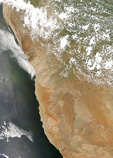
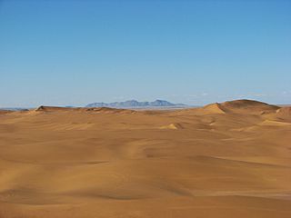
The Namib is a coastal desert in Southern Africa. The name Namib is of Khoekhoegowab origin and means "vast place". According to the broadest definition, the Namib stretches for more than 2,000 kilometres (1,200 mi) along the Atlantic coasts of Angola, Namibia, and South Africa, extending southward from the Carunjamba River in Angola, through Namibia and to the Olifants River in Western Cape, South Africa. The Namib's northernmost portion, which extends 450 kilometres (280 mi) from the Angola-Namibia border, is known as Moçâmedes Desert, while its southern portion approaches the neighboring Kalahari Desert. From the Atlantic coast eastward, the Namib gradually ascends in elevation, reaching up to 200 kilometres (120 mi) inland to the foot of the Great Escarpment. Annual precipitation ranges from 2 millimetres (0.079 in) in the most arid regions to 200 millimetres (7.9 in) at the escarpment, making the Namib the only true desert in southern Africa. Having endured arid or semi-arid conditions for roughly 55–80 million years, the Namib may be the oldest desert in the world and contains some of the world's driest regions, with only western South America's Atacama Desert to challenge it for age and aridity benchmarks.

The Namib-Naukluft Park is a national park in western Namibia, situated between the coast of the Atlantic Ocean and the edge of the Great Escarpment. It encompasses part of the Namib Desert, the Naukluft mountain range, and the lagoon at Sandwich Harbour. The best-known area of the park and one of the main visitor attractions in Namibia is Sossusvlei, a clay pan surrounded by dunes, and Sesriem, a small canyon of the Tsauchab. The desert research station of Gobabeb is situated within the park.
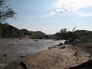
The Kuiseb River is an ephemeral river in western-central Namibia. Its source is in the Khomas Highland west of Windhoek. From there it flows westwards through the Namib-Naukluft National Park and the Namib desert to Walvis Bay. Several settlements of the Topnaar people are on the banks of the lower Kuiseb, for instance Homeb, Sandfontein, Rooibank, and Utuseb. Inflows of the Kuiseb are Gomab, Ojab, Chausib, Gaub, Koam, Nausgomab and Goagos.

Erongo is one of the 14 regions of Namibia. The capital is Swakopmund. It is named after Mount Erongo, a well-known landmark in Namibia and in this area. Erongo contains the municipalities of Walvis Bay, Swakopmund, Henties Bay and Omaruru, as well as the towns Arandis, Karibib and Usakos. All the main centres within this region are connected by paved roads.

The Skeleton Coast is the northern part of the Atlantic coast of Namibia and south of Angola from the Kunene River south to the Swakop River, although the name is sometimes used to describe the entire Namib Desert coast. The Bushmen of the Namibian interior called the region "The Land God Made in Anger", while Portuguese sailors once referred to it as "The Gates of Hell". On the coast, the upwelling of the cold Benguela current gives rise to dense ocean fogs for much of the year. The winds blow from land to sea, rainfall rarely exceeds 10 millimetres (0.39 in) annually and the climate is highly inhospitable. There is a constant, heavy surf on the beaches. In the days before engine-powered ships and boats, it was possible to get ashore through the surf but impossible to launch from the shore. The only way out was by going through a marsh hundreds of kilometres long and only accessible via a hot and arid desert.

Swakopmund is a city on the coast of western Namibia, 352 km (219 mi) west of the Namibian capital Windhoek via the B2 main road. It is the capital of the Erongo administrative district. The town has 44,725 inhabitants and covers 196 square kilometres (76 sq mi) of land. The city is situated in the Namib Desert and is the fourth largest population centre in Namibia.

Otjiwarongo is a city of 28,000 inhabitants in the Otjozondjupa Region of Namibia. It is the district capital of the Otjiwarongo electoral constituency and also the capital of Otjozondjupa.

The Rössing Uranium Mine in Namibia is the longest-running and one of the largest open pit uranium mines in the world. It is located in the Namib Desert near the town of Arandis, 70 kilometres from the coastal town of Swakopmund. Discovered in 1928, the Rössing mine started operations in 1976. In 2005, it produced 3,711 tonnes of uranium oxide, becoming the fifth-largest uranium mine with 8 per cent of global output. Namibia is the world's fourth-largest exporter of uranium.

Veldskoene ("FELT-skoona") or colloquially vellies ("FELL-ys"), are South African walking shoes made from vegetable-tanned leather or soft rawhide uppers attached to a leather footbed and rubber sole without tacks or nails.

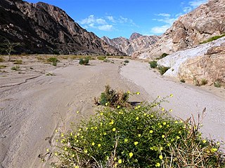
The Swakop River is a major river in western central Namibia. Its river source is in the Khomas Highland. From there it flows westwards through the town of Okahandja, the historic mission station at Gross Barmen, and the settlement of Otjimbingwe. It then crosses the Namib desert and reaches the Atlantic Ocean at Swakopmund. The Swakop is an ephemeral river; its run-off is roughly 40 million cubic metres per annum.

Tourism in Namibia is a major industry, contributing N$7.2 billion to the country's gross domestic product. Annually, over one million travelers visit Namibia, with roughly one in three coming from South Africa, then Germany and finally the United Kingdom, Italy and France. The country is among the prime destinations in Africa and is known for ecotourism which features Namibia's extensive wildlife.
The river Khan is an ephemeral river crossing the Erongo region of central Namibia. It is the main tributary of the Swakop River and only occasionally carries surface water during the rain seasons in November and February/March. Khan's catchment area including its tributaries Slang and Etiro is 8,400 square kilometres (3,200 sq mi).

Rail service in Namibia is provided by TransNamib. The Namibian rail network consists of 2,687 route-km of tracks (2017).
Dorob National Park is a protected area in Erongo, along the central Namibian coast, which is 1,600 kilometres (990 mi) in length. It was gazetted as a national park under the Nature Conservation Ordinance No.4 of 1975 on 1 December 2010, and with Namib-Naukluft Park covers an area of 107,540 square kilometres (41,520 sq mi).

The Husab Mine, also known as the Husab Uranium Project, is a uranium mine near the town of Swakopmund in the Erongo region of western-central Namibia. The mine is located approximately 60 kilometres (37 mi) from Walvis Bay. The Husab Mine is expected to be the second largest uranium mine in the world after the McArthur River uranium mine in northern Saskatchewan, Canada and the largest open-pit mine on the African continent. Mine construction started in 2014. The Husab Mine started production towards the end of 2016 after completion of the sulfuric acid leaching plant.

Hong Kong–Namibia relations refers to the international relations between Hong Kong and Namibia.
Mondesa is a suburb of Swakopmund in central western Namibia. The district is located in the northeast of the city. In the northwest, it borders on the district Tamariskia, in the south on the industrial area. Otherwise, Mondesa is surrounded by the Namib Desert, with the Democratic Resettlement Community (DRC) spreading out about one kilometre apart in the northeast, officially acclaimed in 2003 by the city administration slum district of Swakopmund. Originally Mondesa was a township for the Black people of Swakopmund. It is also the fastest-growing district with an ever-growing population. In 2017 the Swakopmund municipality erected a wall obstructing the view on the township for people entering town. The Namibian, Namibia's largest English newspaper, called it a "Wall of shame".
Rosina ǁHoabes is a Namibian politician.

Squatting in Namibia is the occupation of unused land or derelict buildings without the permission of the owner. After Namibian independence in 1990, squatting increased as people migrated to the cities. By 2020, 401,748 people were living in 113 informal settlements across the country.
Events in the year 2001 in Namibia.
