Herbert Sound is a sound in Antarctica extending from Cape Lachman and Keltie Head on the northwest to the narrows between The Naze and False Island Point on the southeast, separating Vega Island from James Ross Island and connecting Prince Gustav Channel with Erebus and Terror Gulf. On January 6, 1843 Captain James Clark Ross discovered a broad embayment east of the sound, which he named "Sidney Herbert Bay" after Sidney Herbert, First Secretary to the Admiralty. The sound proper was discovered and charted by the Swedish Antarctic Expedition, 1901–04, under Otto Nordenskiöld, who included it with the broad embayment under the name "Sidney Herbert Sound". The recommended application restricts Herbert Sound to the area west of the narrows between The Naze and False Island Point; the embayment discovered by Ross forms the western margin of Erebus and Terror Gulf.
Wilson Hills is a group of scattered hills, nunataks and ridges that extend NW-SE for about 110 kilometres (68 mi) between Matusevich Glacier and Pryor Glacier in Antarctica. They were discovered by Lieutenant Harry Pennell, Royal Navy, on the Terra Nova Expedition in February 1911 during Robert Falcon Scott's last expedition, and named after Dr. Edward A. Wilson, a zoologist with the expedition, who perished with Scott on the return journey from the South Pole.
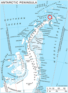
Astrolabe Island, located at 63°17′S58°40′W, is an island 5 km (3 mi) long, lying in the Bransfield Strait 23 km (14 mi) northwest of Cape Ducorps, Trinity Peninsula in Antarctica. It was discovered by the French expedition, 1837–40, under Captain Jules Dumont d'Urville, and named by him for his chief expedition ship, the Astrolabe. The island was photographed from the air and triangulated by FIDASE, 1956-57.
Thuma Peak is a mainly ice-free peak in the Desko Mountains, rising 2 miles (3 km) northwest of Overton Peak in southeast Rothschild Island. It was named by the Advisory Committee on Antarctic Names for Captain Jack S. Thuma, U.S. Coast Guard.

Arena Glacier is a glacier 3 nautical miles (6 km) long, flowing northeast from Mount Taylor into Hope Bay 2 nautical miles (4 km) southwest of Sheppard Point, at the extremity of the Trinity Peninsula. It was mapped in 1948 and 1955 by the Falkland Islands Dependencies Survey and so named by them because the flat ice floor of the glacier's upper half, surrounded by the steep slopes of Twin Peaks, Mount Taylor and Blade Ridge, resembles an arena.
Blancmange Hill is an outstanding ice-free coastal landmark located 3 nautical miles (6 km) northeast of Stark Point on the east side of Croft Bay, James Ross Island. It was named by the UK Antarctic Place-Names Committee following Falkland Islands Dependencies Survey surveys taken 1958–61. The name is descriptive since the feature resembles a blancmange.
Blow-me-down Bluff is a prominent rock bluff, 1,820 metres (5,970 ft) high, standing at the north flank of Northeast Glacier on the west side of Graham Land. It was roughly surveyed in 1936 by the British Graham Land Expedition, and by the United States Antarctic Service in 1940. It was re-surveyed in 1946 and 1948 by the Falkland Islands Dependencies Survey (FIDS), who so named it because the bluff stands in the windiest part of Northeast Glacier and many members of FIDS sledge parties have fallen in this area in high winds.
Boot Rock is a rock, 30 metres (100 ft) high, which lies 0.1 nautical miles (0.2 km) off the southeast side of Candlemas Island in the South Sandwich Islands. It was charted and named by Discovery Investigations personnel on the Discovery II in 1930.
Kraken Cove is the largest cove at Candlemas Island, South Sandwich Islands, indenting the north coast of the island just west of Demon Point. The name applied by the UK Antarctic Place-Names Committee in 1971 is that of a legendary Norwegian sea monster, the Kraken.
Fry Peak is a sharp-pointed peak which is the southernmost peak in the Welch Mountains, in Palmer Land, Antarctica. It was mapped by the United States Geological Survey in 1974, and was named by the Advisory Committee on Antarctic Names for Lieutenant Frederick M. Fry, U.S. Navy, a Flight Surgeon and member of the para-rescue team of U.S. Navy Squadron VXE-6 during Operation Deep Freeze 1969 and 1970.
Grimley Glacier is a tributary glacier, 15 nautical miles (28 km) long and 3 nautical miles (6 km) wide, lying 3 nautical miles north of Sunfix Glacier and flowing east-northeast into Casey Glacier in northern Palmer Land, Antarctica. The glacier was photographed from the air by the United States Antarctic Service on September 28, 1940, and by the Ronne Antarctic Research Expedition on December 22, 1947. It was surveyed by the Falkland Islands Dependencies Survey (FIDS) in December 1960 and was named by the UK Antarctic Place-Names Committee for Peter H. Grimley of FIDS, a geologist at Horseshoe Island and Stonington Island in 1960.
Elkhorn Ridge is a rugged ridge, 10 nautical miles (19 km) long, between Towle Glacier and Northwind Glacier in the Convoy Range of Victoria Land. It was mapped by the United States Geological Survey from ground surveys and Navy air photos, and was named by the Advisory Committee on Antarctic Names in 1964 for the USNS Elkhorn, a tanker in the American convoy into McMurdo Sound, 1961–62.
Fivemile Rock is a small nunatak, 375 metres (1,230 ft) high, rising just northwest of Mineral Hill on Tabarin Peninsula, Antarctica. It was mapped in 1946 and again in 1956 by the Falkland Islands Dependencies Survey, and so named because the feature is located 5 nautical miles (9 km) from their station at Hope Bay on the route from there to Duse Bay.
Foca Point is a rocky point forming the south side of the entrance to Express Cove on the west side of Signy Island in the South Orkney Islands. It was surveyed in 1947 by the Falkland Islands Dependencies Survey, and was named by the UK Antarctic Place-Names Committee for the whale catcher Foca, belonging to the Compañía Argentina de Pesca, which visited the South Orkney Islands in December 1926.
Mitchell Point is a point at the south side of the entrance to Hill Bay on the east coast of Brabant Island, in the Palmer Archipelago, Antarctica. It was photographed by Hunting Aerosurveys Ltd in 1956–57, and was mapped from these photos in 1959. The point was named by the UK Antarctic Place-Names Committee for American surgeon Silas W. Mitchell, the founder of neurology in the United States.
Hill Glacier is a broad glacier that drains the west-central part of Spaatz Island, Antarctica, at the south side of Ronne Entrance. It was mapped by the United States Geological Survey (USGS) from surveys and U.S. Navy aerial photographs, 1961–66, and was named by the Advisory Committee on Antarctic Names for Lennie J. Hill, a USGS topographic engineer who was a member of the Marie Byrd Land Survey Party, 1967–68.
Schaus Ice Rises is a group of small ice rises merged within the Wilkins Ice Shelf, aligned east-west just off the north side of Eroica Peninsula, situated off the southwest coast of Alexander Island, Antarctica. Mapped by United States Geological Survey (USGS) from U.S. Navy aerial photographs taken 1967-68 and from Landsat imagery taken 1972-73. Named by Advisory Committee on Antarctic Names (US-ACAN) for Commander Richard Schaus, U.S. Navy, assigned to the Division of Polar Programs, National Science Foundation (NSF), as aviation projects officer, 1979-80.
Saw Rock is a rock, 25 m high, lying 0.4 nautical miles (0.7 km) north of Crosscut Point, the north extremity of Vindication Island, in the South Sandwich Islands. Charted in 1930 by DI personnel on the Discovery II and named by them, probably for association with Crosscut Point.
Tasch Peak is a rocky peak in the southeast portion of Mount Rees, in the Crary Mountains of Marie Byrd Land. Mapped by United States Geological Survey (USGS) from surveys and U.S. Navy tricamera aerial photographs, 1959-66. Named by Advisory Committee on Antarctic Names (US-ACAN) for Paul Tasch, United States Antarctic Research Program (USARP) geologist in the Sentinel Range and Ohio Range, summer 1966-67, and Coalsack Bluff, 1969-70.
Taylor Point is a point forming the north limit of Destruction Bay, on the east coast of King George Island in the South Shetland Islands. Named by the United Kingdom Antarctic Place-Names Committee (UK-APC) in 1960 for D. Taylor, Master of the Hobart sealing vessel Caroline, which visited the South Shetland Islands in 1821-22.


