
Belgium, officially the Kingdom of Belgium, is a country in Northwestern Europe. The country is bordered by the Netherlands to the north, Germany to the east, Luxembourg to the southeast, France to the south, and the North Sea to the west. It covers an area of 30,689 km2 (11,849 sq mi) and has a population of more than 11.7 million, making it the 22nd most densely populated country in the world and the 6th most densely populated country in Europe, with a density of 383/km2 (990/sq mi). Belgium is part of an area known as the Low Countries, historically a somewhat larger region than the Benelux group of states, as it also included parts of northern France. The capital and largest metropolitan region is Brussels; other major cities are Antwerp, Ghent, Charleroi, Liège, Bruges, Namur, and Leuven.

Flanders is the Dutch-speaking northern portion of Belgium and one of the communities, regions and language areas of Belgium. However, there are several overlapping definitions, including ones related to culture, language, politics, and history, and sometimes involving neighbouring countries. The demonym associated with Flanders is Fleming, while the corresponding adjective is Flemish, which can also refer to the collective of Dutch dialects spoken in that area, or more generally the Belgian variant of Standard Dutch. The official capital of Flanders is the City of Brussels, although the Brussels-Capital Region that includes it has an independent regional government. The powers of the government of Flanders consist, among others, of economic affairs in the Flemish Region and the community aspects of Flanders life in Brussels, such as Flemish culture and education.

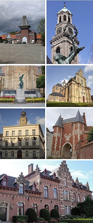
Ghent is a city and a municipality in the Flemish Region of Belgium. It is the capital and largest city of the East Flanders province, and the third largest in the country, after Brussels and Antwerp. It is a port and university city.
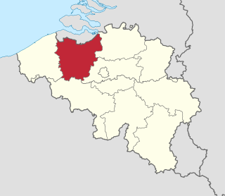
East Flanders is a province of Belgium. It borders the Dutch province of Zeeland and the Flemish province of Antwerp, Flemish Brabant, Hainaut and West Flanders. It has an area of 3,007 km2 (1,161 sq mi), divided into six administrative districts containing 60 municipalities, and a population of over 1.57 million as of January 2024. The capital is Ghent, home to the Ghent University and the Port of Ghent.

Geraardsbergen is a city and municipality located in the Denderstreek and in the Flemish Ardennes, the hilly southern part of the Belgian province of East Flanders. The municipality comprises the city of Geraardsbergen proper and the following towns:
Ninove is a city and municipality in the Flemish province of East Flanders in Belgium. It is on the river Dender, and is part of the Denderstreek. The municipality comprises the city of Ninove proper and since the 1976 merger of the towns of Appelterre-Eichem, Aspelare, Denderwindeke, Lieferinge, Meerbeke, Nederhasselt, Neigem, Okegem, Outer, Pollare and Voorde. On 1 January 2023 Ninove had a total population of 40.090. The total area is 72.57 km2 which gives a population density of 553 inhabitants per km2.

Melle is a municipality located in the Belgian province of East Flanders. The municipality comprises the villages of Gontrode and Melle proper. On 1 January 2018 Melle had a total population of 11,574. The total area is 15.21 km² which gives a population density of 761 inhabitants per km².

Moerbeke is a municipality in the Belgian province of East Flanders. It is sometimes unofficially called Moerbeke-Waas to distinguish between this place and Moerbeke in Geraardsbergen. The municipality comprises the town of Moerbeke proper, and part of the Dutch-Belgian village Koewacht. In 2021, Moerbeke had a total population of 6,619. The total area is 37.80 km².

Oosterzele is a municipality located in the Flemish province of East Flanders, in Belgium. The municipality comprises the towns of Balegem, Gijzenzele, Landskouter, Moortsele, Oosterzele proper and Scheldewindeke. In 2021, Oosterzele had a total population of 13,740. The total area is 43.12 km². Its twin town is Oberkirch in Germany.

Willebroek is a municipality located in the Belgian province of Antwerp. The municipality comprises the towns of Blaasveld, Heindonk, Tisselt, Klein Willebroek, and Willebroek proper. In 2021, Willebroek had a total population of 27,081. The total area is 27.41 km2.

Turnhout is a Belgian municipality and city located in the Flemish province of Antwerp. The municipality comprises only the city of Turnhout proper. In 2021, its population was 45,874. The total area is 56.06 km2 (21.64 sq mi). The agglomeration is much more populous, with 81,473 inhabitants. It is known for its playing card industry, and houses the head office of the world's largest manufacturer of playing cards, Cartamundi. Turnhout is also the capital of the administrative district with the same name. The city council often promotes the city as "the capital of the Kempen area." This designation is entirely unofficial, since the Kempen area is far larger than the Turnhout district and does not form an administrative unit.

Rotselaar is a municipality located in the Belgian province of Flemish-Brabant, near the convergence of the Demer and the Dijle. Since 1 January 1977 the municipality comprises the towns of Rotselaar proper, Werchter and Wezemaal. On 1 January 2006 Rotselaar had a total population of 15,068. The total area is 37.57 km² which gives a population density of 401 inhabitants per km².
Tervuren is a municipality in the province of Flemish Brabant, in the Flemish region of Belgium. The municipality comprises the villages of Duisburg, Tervuren proper, Vossem and Moorsel. On 1 January 2006, Tervuren had a total population of 20,636. The total area is 32.92 km2 (12.71 sq mi), which gives a population density of 627/km2 (1,620/sq mi).
The music of Belgium is a cultural mix where Flemish Dutch-speaking and Walloon French-speaking traditions mix with those of German minorities and of immigrant communities from Democratic Republic of the Congo or other distant countries.

Boom is a Belgian town, located in both the arrondissement and province of Antwerp. In 2021, Boom had a total population of 18,799. The total area is 7.37 km2. Residents are known as "Boomenaren".

Kermesse, or kermis, or kirmess, is an outdoor fair or festival usually organized for charitable purposes. The term was derived from 'kerk' (church) and 'mis' (mass) in the original Dutch language term, and was borrowed in English, French, Spanish and many other languages. It originally denoted a mass and patronal festival held on the anniversary of the foundation of a church and in honour of the patron saint. Such celebrations were regularly held in the Low Countries, in Central Europe and also in northern France, and were accompanied by feasting, dancing and competitions of all kinds. The Kirchweih is the German equivalent, while church ale was a name of similar festivals in England. Many Catholic churches (parishes) still have patronal festivals of some sort for the anniversary of the church's founding, or the feast day of the saint it is dedicated to.

De Klinge is a Belgian town and part of the municipality of Sint-Gillis-Waas in the province of East Flanders (Oost-Vlaanderen), is located on the border with the Netherlands province of Zeeland and within the non-administrative region known as the Waasland or the Land van Waas. On the Dutch side of the border the town is called Clinge and is part of the municipality of Hulst. Sint-Niklaas is 10 kilometres south of De Klinge. The nearest large Belgian city is Antwerp (Antwerpen) to the east. The town is bordered by many forests, including the Stropersbos, which are excellent for cycling and walking.

Flemish people or Flemings are a Germanic ethnic group native to Flanders, Belgium, who speak Flemish Dutch. Flemish people make up the majority of Belgians, at about 60%.
Despite its size, Belgium has a long and distinguished artistic tradition that goes back to the Middle Ages, considerably pre-dating the foundation of the current state in 1830. Art from the areas making up modern Belgium is called in English Netherlandish up to the separation with the Netherlands from 1570 on, and Flemish until the 18th century.
The County of Flanders was one of the most powerful political entities in the medieval Low Countries, located on the North Sea coast of what is now Belgium. Unlike its neighbours, such as the counties of Brabant and Hainaut, it was within the territory of the Kingdom of France. The counts of Flanders held the most northerly part of the kingdom, and were among the original twelve peers of France. For centuries, the economic activity of the Flemish cities, such as Ghent, Bruges and Ypres, made Flanders one of the most affluent regions in Europe, and also gave them strong international connections to trading partners.


