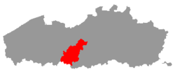
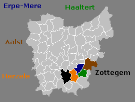
Erpe-Mere is a municipality located in the Belgian province of East Flanders in the Denderstreek. The municipality comprises the towns of Aaigem, Bambrugge, Burst, Erondegem, Erpe, Mere, Ottergem and Vlekkem. There is also a hamlet in Bambrugge: Egem. Erpe-Mere is crossed by 2 brooks, the Molenbeek and the Molenbeek-Ter Erpenbeek. In 2022 Erpe-Mere had a total population of 20,127. The total area is 34.03 km2. The current mayor of Erpe-Mere is Hugo De Waele, from the CD&V party.

Haaltert is a municipality located in the Belgian province of East Flanders in the Denderstreek. The municipality comprises the towns of Denderhoutem, Haaltert proper, Heldergem and Kerksken. In 2021, Haaltert had a total population of 18,892. The total area is 30.30 km². The current mayor of Haaltert is Veerle Baeyens, from the N-VA.
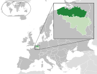
Articles related to Belgium include:

The Dender or Dendre is a 65-kilometre (40-mile) long river in Belgium, the right tributary of the river Scheldt. The confluence of the two rivers is in the Belgian town of Dendermonde.

The Arrondissement of Oudenaarde is one of the six administrative arrondissements in the Province of East Flanders, Belgium. It is both an administrative and a judicial arrondissement. However, the Judicial Arrondissement of Oudenaarde also comprises the municipalities of Geraardsbergen, Herzele, Sint-Lievens-Houtem and Zottegem in the Arrondissement of Aalst.

The Arrondissement of Aalst is one of the six administrative arrondissements in the Province of East Flanders, Belgium. It forms the Judicial Arrondissement of Dendermonde together with the Arrondissements of Dendermonde and Sint-Niklaas.

The Arrondissement of Dendermonde is one of the six administrative arrondissements in the Province of East Flanders, Belgium. It is both an administrative and a judicial arrondissement. However, the Judicial Arrondissement of Dendermonde also comprises the municipalities of the Arrondissements of Aalst and Sint-Niklaas.
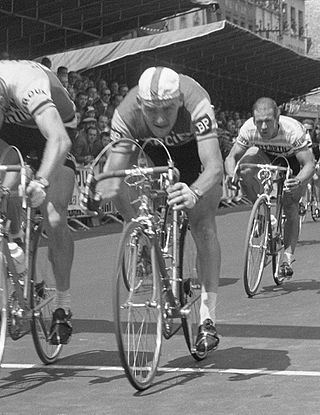
Frans Melckenbeeck is a retired Belgian professional road bicycle racer. In 1962, Melckenbeeck won one stage of the Tour de France, and in 1963 he won Liège–Bastogne–Liège. He won 4 stages in the 1964 and 1965 Vuelta a España. Melckenbeeck also competed in the team pursuit at the 1960 Summer Olympics.

Aaigem is a village belonging to the municipality of Erpe-Mere. It is located in the province of East Flanders, Belgium. The village has some 2000 inhabitants. Aaigem was an independent municipality with an area of 7.32 square kilometers till 1976.
Bambrugge is a sub-municipality of Erpe-Mere in Flanders. It is located on the Molenbeek in the Denderstreek, southeast of East Flanders and belongs to the Arrondissement of Aalst. It is bordered by the sub-municipalities of Vlekkem, Ottergem, Mere, Aaigem and Burst and the municipality of Sint-Lievens-Houtem. Bambrugge has 1575 inhabitants as of 1 January 2003 and has an area of 2.89 km. The population density is 545 inhabitants / km ². Bambrugge has also a hamlet: Egem.
Burst is a sub-municipality of Erpe-Mere in Belgium. It is located on the Molenbeek in the Denderstreek, southeast of East Flanders and belongs to the Arrondissement of Aalst. It is bordered by the sub-municipalities of Bambrugge and Aaigem, as well as the municipalities of Herzele and Sint-Lievens-Houtem. Burst had 2968 inhabitants on 1 January 2003 and an area of 3.83 km. The population density was 776 / km ².
Erpe is a sub-municipality of Erpe-Mere in Flanders, Belgium, on the Molenbeek-Ter Erpenbeek in the Denderstreek in the southeast of East Flanders and belongs to Arrondissement of Aalst. The sub-municipality is bordered by the sub-municipalities of Mere, Ottergem, and Erondegem and the municipalities Lede and Aalst. Erpe has 4903 inhabitants as of 1 January 2003 and an area of 8.28 km2 (3.20 sq mi). The population density is 592/km2 (1,530/sq mi).
Mere is a sub-municipality of Erpe-Mere in Flanders. It is located on the Molenbeek-Ter Erpenbeek in the Denderstreek in the southeast of East Flanders and belongs to Arrondissement of Aalst. It is bordered by the sub-municipalities of Erpe, Ottergem, Bambrugge and Aaigem and the municipalities Haaltert and Aalst. Mere has 5033 inhabitants as of 1 January 2003 and an area of 5.77 km. The population density is 873 inhabitants / km ².
Erondegem is a sub-municipality of Erpe-Mere in Flanders, Belgium. It is located on the Molenbeek in the Denderstreek, southeast of East Flanders and belongs to the Arrondissement of Aalst. It is bordered by the sub-municipalities of Erpe and Ottergem and the municipalities of Sint-Lievens-Houtem and Lede. Erondegem has 1628 inhabitants as of 1 January 2003 and an area of 3.17 km. The population density is 513 inhabitants / km ².
Ottergem is a sub-municipality of Erpe-Mere in Flanders, Belgium. It is located on the Molenbeek in the Denderstreek, southeast of East Flanders and belongs to the Arrondissement of Aalst. The sub-municipality is bordered by the sub-municipalities of Erondegem, Erpe, Mere, Bambrugge and Vlekkem and the municipality Sint-Lievens-Houtem. Ottergem has 500 inhabitants as of 1 January 2003 and an area of 1.55 km. The population density is 322 inhabitants / km².
Vlekkem is a sub-municipality of Erpe-Mere in Flanders, Belgium. It is located on the Molenbeek in the Denderstreek, southeast of East Flanders and belongs to the Arrondissement of Aalst. The sub-municipality is bordered by the hamlet Egem of the sub-municipality Bambrugge, the sub-municipality Ottergem and the municipality Sint-Lievens-Houtem. Vlekkem has 292 inhabitants as of 1 January 2003 and an area of 1.22 km. The population density is 240 inhabitants / km².
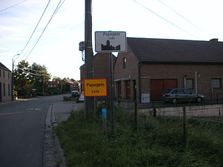
Papegem is a village in the municipality of Lede located in the Belgian province of East Flanders in the Denderstreek. It has an area of 0.58 km². The Wellebeek which flows there belongs to the basin of the Molenbeek which originates from the Upper Scheldt, and flows through Erpe-Mere. In the past the Wellebeek was called the Papegemsche beek. It is bordered by the sub-municipalities of Oordegem, Smetlede and Impe, as well as the municipalities of Sint-Lievens-Houtem and Erpe-Mere (sub-municipality Erondegem, despite the small size of Papegem. In Papegem the Sint-Macharius Chapel can be found. Papegem belongs to the deanery of Herzele-Houtem.

Egem is a hamlet in the sub-municipality of Bambrugge in the municipality of Erpe-Mere in Flanders, Belgium. It is located on the Molenbeek, in the Denderstreek, within the southeast of East Flanders and belongs to the Arrondissement of Aalst. It is bordered by the sub-municipalities of Bambrugge proper, Vlekkem, Ottergem and Zonnegem. Egem also borders the domain Steenberg. Egem consists of two streets, the Egemstraat and Everdal.

The Molenbeek is a brook in the Denderstreek, Belgium. The stream has a length of approximately 22 kilometers. The source of the Molenbeek is located in Grotenberge and the delta is in nearby Wichelen. This brook is not to be confused with the 25-km-lomg Molenbeek-Ter Erpenbeek which is also in Erpe-Mere. The 25-km brook is part of the Molenbeek Erpe-Mere drainage basin.
The Molenbeek-Ter Erpenbeek or in popular language Molenbeek is a brook in the Denderstreek region of Belgium. The stream has a length of approximately 25 kilometers. The source of the Molenbeek is in Godveerdegem and the delta is located at Hofstade. This brook is not to be confused with a 22-km water body called Molenbeek, which also flows through Erpe-Mere. The 22-km Molenbeek is part of the Drie Molenbeken drainage basin.