
Anderlecht is one of the 19 municipalities of the Brussels-Capital Region, Belgium. Located in the south-western part of the region, it is bordered by the City of Brussels, Forest, Molenbeek-Saint-Jean, and Saint-Gilles, as well as the Flemish municipalities of Dilbeek and Sint-Pieters-Leeuw. In common with all of Brussels' municipalities, it is legally bilingual (French–Dutch).

Molenbeek-Saint-Jean or Sint-Jans-Molenbeek, often simply called Molenbeek, is one of the 19 municipalities of the Brussels-Capital Region, Belgium. Located in the western part of the region, it is bordered by the City of Brussels, from which it is separated by the Brussels–Charleroi Canal, as well as by the municipalities of Anderlecht, Berchem-Sainte-Agathe, Dilbeek, Jette, and Koekelberg. The Molenbeek brook, from which it takes its name, flows through the municipality. In common with all of Brussels' municipalities, it is legally bilingual (French–Dutch).

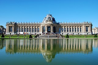
Woluwe-Saint-Pierre or Sint-Pieters-Woluwe is one of the 19 municipalities of the Brussels-Capital Region, Belgium. Located in the eastern part of the region, it is bordered by Etterbeek, Auderghem and Woluwe-Saint-Lambert, as well as the Flemish municipalities of Kraainem and Tervuren. In common with all of Brussels' municipalities, it is legally bilingual (French–Dutch).

Erpe-Mere is a municipality located in the Belgian province of East Flanders in the Denderstreek. The municipality comprises the towns of Aaigem, Bambrugge, Burst, Erondegem, Erpe, Mere, Ottergem and Vlekkem. There is also a hamlet in Bambrugge: Egem. Erpe-Mere is crossed by 2 brooks, the Molenbeek and the Molenbeek-Ter Erpenbeek. In 2022 Erpe-Mere had a total population of 20,127. The total area is 34.03 km². The current mayor of Erpe-Mere is Hugo De Waele, from the CD&V party.

Herzele is a municipality located in the Belgian province of East Flanders in the Denderstreek. The municipality comprises the villages of Borsbeke, Herzele proper, Hillegem, Ressegem, Sint-Antelinks, Sint-Lievens-Esse, Steenhuize-Wijnhuize and Woubrechtegem. In 2021, Herzele had a total population of 18,414. The total area is 47.40 km². The current mayor of Herzele is Johan Van Tittelboom, from the Open Flemish Liberals and Democrats party.

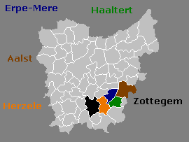
Zottegem is a municipality located in Belgium and more particularly in Flanders, in the province of East Flanders. The municipality comprises the town of Zottegem proper and the villages of Elene, Erwetegem, Godveerdegem, Grotenberge, Leeuwergem, Oombergen, Sint-Goriks-Oudenhove, Sint-Maria-Oudenhove, Strijpen and Velzeke-Ruddershove. On 1 January 2018, Zottegem had a total population of 26,373. The total area is 56.66 km2 which gives a population density of 470 inhabitants per km2.

Kalmthout is a municipality in the Belgian province of Antwerp. The municipality comprises the villages of Kalmthout, Achterbroek, Heide, and Nieuwmoer. In 2021, Kalmthout had a population of 19,020. The total area is 59.45 square kilometres (22.95 sq mi).
Tervuren is a municipality in the province of Flemish Brabant, in Flanders, Belgium. The municipality comprises the villages of Duisburg, Tervuren, Vossem and Moorsel. On January 1, 2006, Tervuren had a total population of 20,636. The total area is 32.92 km², which gives it a population density of 627 inhabitants per km².

Schaerbeek or Schaarbeek is one of the 19 municipalities of the Brussels-Capital Region, Belgium. Located in the north-eastern part of the region, it is bordered by the City of Brussels, Etterbeek, Evere and Saint-Josse-ten-Noode. In common with all of Brussels' municipalities, it is legally bilingual (French–Dutch).

Sint-Goriks-Oudenhove is a village situated in the municipality of Zottegem, Belgium. It is located in the Flemish Ardennes, the hilly southern part of the province of East Flanders.

Brussels-North railway station, officially Brussels-North, is one of the three major railway stations in Brussels, Belgium; the other two are Brussels-Central and Brussels-South. Every regular domestic and international train passing there has a planned stop. The station has 200,000 passengers per week, mainly commuters, making it one of the busiest in Belgium.

Nederbrakel is a town in the municipality of Brakel. It is located in the Denderstreek and in the Flemish Ardennes, the hilly southern part of the province of East Flanders, Belgium. With 5,972 residents as of 2000, it forms the largest individual part of the municipality. Nederbrakel is located near the language border.

Michelbeke is a village in the municipality of Brakel, Belgium. It is located in the Denderstreek and in the Flemish Ardennes, the hilly southern part of the province of East Flanders, Belgium. It was itself a municipality until the fusion of the municipalities on 1 January 1971.
Sint-Maria-Oudenhove is a village in the Denderstreek and in the Flemish Ardennes, the hilly southern part of the province of East Flanders, Belgium.

Velzeke-Ruddershove is a double village in the Denderstreek in the province of East Flanders in Belgium, currently part of the municipality of Zottegem.
Godveerdegem is a village belonging to the municipality of Zottegem. It is located on the Molenbeek-Ter Erpenbeek in the Denderstreek and in the Flemish Ardennes, the hilly southern part of the province of East Flanders, Belgium.
Leeuwergem is a village belonging to the municipality of Zottegem. It is located on the Molenbeek, in the Denderstreek and Flemish Ardennes, which is part of the hilly southern part of the East Flanders province, Belgium.

Erwetegem is a village and deelgemeente (sub-municipality) belonging to the municipality of Zottegem. It is located in the Denderstreek and in the Flemish Ardennes, the hilly southern part of the province of East Flanders, Belgium. Erwetegem used to be an independent municipality until 1970.

Woluwe-Saint-Lambert or Sint-Lambrechts-Woluwe is one of the 19 municipalities of the Brussels-Capital Region, Belgium. In common with all of Brussels' municipalities, it is legally bilingual (French–Dutch). In French, it is often spelt Woluwé-Saint-Lambert to reflect the Frenchified pronunciation of what was originally a Dutch place name, but the official spelling is without an accent. The Woluwe stream, from which it takes its name, flows through the municipality.
The Molenbeek-Ter Erpenbeek or in popular language Molenbeek is a brook in the Denderstreek, Belgium. The stream has a length of approximately 25 kilometers. The source of the Molenbeek is in Godveerdegem and the delta is located at Hofstade. This brook is not to be confused with another Molenbeek which also flows through Erpe-Mere.

