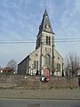
Sint-Lievens-Houtem is a Dutch-speaking municipality of Belgium. It is located in the Denderstreek and at the edge of the Flemish Ardennes, the hilly southern part of the province of East Flanders. Sint-Lievens-Houtem is crossed by the Molenbeek in Vlierzele, Zonnegem and Letterhoutem.

Buggenhout is a municipality in the Belgian province of East Flanders in the Denderstreek. The municipality comprises the towns of Buggenhout proper, Briel, Opdorp, and Opstal. In 2021, Buggenhout had a total population of 14,689. The total area is 25.25 square kilometres.

Aalter is a municipality located between Bruges and Ghent in the Belgian province of East Flanders. The municipality comprises the towns of Aalter, Bellem, Lotenhulle, Poeke, Knesselare and Ursel. It is bordered on the north by Maldegem, on the east by Zomergem and Nevele, on the south by Deinze, and on the west by the province of West Flanders. The mayor is Pieter De Crem.

Gavere is a municipality located in the Belgian province of East Flanders. The municipality comprises the towns of Asper, Baaigem, Dikkelvenne, Gavere, Semmerzake and Vurste. In 2021, Gavere had a total population of 13,007. The total area is 31.35 km².

Melle is a municipality located in the Belgian province of East Flanders. The municipality comprises the villages of Gontrode and Melle proper. On 1 January 2018 Melle had a total population of 11,574. The total area is 15.21 km² which gives a population density of 761 inhabitants per km².

Merelbeke is a municipality located in the Flemish province of East Flanders, in Belgium. The municipality comprises the villages of Bottelare, Lemberge, Melsen, Merelbeke proper, Munte and Schelderode. In 2021, Merelbeke had a total population of 24,779. The total area is 36.65 km².
Wuustwezel is a municipality located in the north of the Belgian province of Antwerp.
Oud-Turnhout is a municipality located in the Belgian province of Antwerp. The municipality only comprises the town of Oud-Turnhout proper. In 2021, Oud-Turnhout had a total population of 14,201. The total area is 38.80 km².

Berchem is a southern district of the municipality and city of Antwerp in the Flemish Region of Belgium. Berchem is located along the old Grote Steenweg that has connected Brussels to Antwerp for several centuries; the town borders the districts of Deurne, Borgerhout, Wilrijk and Antwerp and the municipality of Mortsel. Berchem itself consists of three quarters, Oud Berchem, Groenenhoek and Nieuw Kwartier.

Maubeuge is a commune in the Nord department in northern France.

Nederbrakel is a town in the municipality of Brakel. It is located in the Denderstreek and in the Flemish Ardennes, the hilly southern part of the province of East Flanders, Belgium. With 5,972 residents as of 2000, it forms the largest individual part of the municipality. Nederbrakel is located near the language border.

Kanne is a village in the municipality of Riemst in the southeastern part of the Belgian province of Limburg. as of 2021, the village has 1,162 inhabitants of which a significant part have the Dutch nationality.

Velzeke-Ruddershove is a double village in the Denderstreek in the province of East Flanders in Belgium, currently part of the municipality of Zottegem.

Burst is a sub-municipality of Erpe-Mere in Belgium. It is located on the Molenbeek in the Denderstreek, southeast of East Flanders and belongs to the Arrondissement of Aalst. It is bordered by the sub-municipalities of Bambrugge and Aaigem, as well as the municipalities of Herzele and Sint-Lievens-Houtem. Burst had 2968 inhabitants on 1 January 2003 and an area of 3.83 km. The population density was 776 / km ².

Beerlegem is a village belonging to the municipality of Zwalm. It is located in the Flemish Ardennes, the hilly southern part of the province of East Flanders, Belgium. Until 1970, it was an independent municipality.

Grotenberge is a village belonging to the municipality of Zottegem. It is located on the Molenbeek and the Molenbeek-Ter Erpenbeek within the Denderstreek and the Flemish Ardennes, the hilly southern part of the East Flanders province, Belgium.
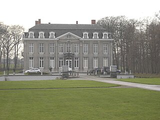
Leeuwergem is a village belonging to the municipality of Zottegem. It is located on the Molenbeek, in the Denderstreek and Flemish Ardennes, which is part of the hilly southern part of the East Flanders province, Belgium.

Melden is a village belonging partly to the municipality of Oudenaarde and partly to the municipality of Kluisbergen. It is located in the Flemish Ardennes, the hilly southern part of the province of East Flanders, Belgium.

Eine is a village located in the province of East Flanders, Belgium. Since 1965, it has been a deelgemeente (subdivision) of the municipality of Oudenaarde.

Maarke-Kerkem is a village in the Flemish Ardennes, the hilly southern part of the province of East Flanders, Belgium. It is formed by two hamlets, Maarke and Kerkem, and is incorporated in the municipality of Maarkedal. It is hosting the Saint Vincent Chapel, which was first erected around 1100.