
Clearwater County is a county located in the U.S. state of Idaho. As of the 2020 census, the population was 8,734. The county seat is Orofino. Established in 1911, the county was named after the Clearwater River. The county is home to North Fork of the Clearwater River, and a small portion of the South Fork and the main Clearwater. Also in the county are the Dworshak Reservoir, Dworshak State Park, Dworshak National Fish Hatchery, and the Dworshak Dam, third highest in the U.S. The modest Bald Mountain ski area is located between Orofino and Pierce.

Detroit Dam is a gravity dam on the North Santiam River between Linn County and Marion County, Oregon. It is located in the Cascades, about 5 mi (8.0 km) west of the city of Detroit. It was constructed between 1949 and 1953 by the United States Army Corps of Engineers. The dam created 400-foot (120 m) deep Detroit Lake, more than 9 miles (14 km) long with 32 miles (51 km) of shoreline.

Henry Clarence Dworshak Jr. was a United States senator and congressman from Idaho. Originally from Minnesota, he was a Republican from Burley, and served over 22 years in the House and Senate.

North Central Idaho is an area which spans the central part of the state of Idaho and borders Oregon, Montana, and Washington. It is the southern half of the state's Panhandle region and is rich in agriculture and natural resources. Lewis and Clark traveled through this area on their journey to the Pacific Ocean in September 1805, crossing Lolo Pass and continuing westward in canoes on the Clearwater River. They returned the following spring on their way eastward.
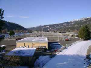
Dworshak National Fish Hatchery is a mitigation hatchery located on the Clearwater River within the Nez Perce Reservation near Ahsahka, in north-central Idaho, United States. It was constructed in 1969 by the Army Corps of Engineers, and is co-managed by the U.S. Fish and Wildlife Service and the Nez Perce Tribe. The hatchery is one of the largest combination producers of anadromous (migratory) fish in the world. These fish make a 1000-mile round trip to the ocean and back to spawn in the Clearwater River. The Dworshak Dam blocks access to the historical spawning areas on the North Fork-Clearwater River for the steelhead, and it is too high for a fish ladder.

Clearwater National Forest with headquarters on the Nez Perce Reservation at Kamiah is located in North Central Idaho in the northwestern United States. The forest is bounded on the east by the state of Montana, on the north by the Idaho Panhandle National Forest, and on the south and west by the Nez Perce National Forest and Palouse Prairie.
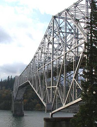
The Bridge of the Gods is a steel truss cantilever bridge that spans the Columbia River between Cascade Locks, Oregon, and Washington state near North Bonneville. It is approximately 40 miles (64 km) east of Portland, Oregon, and 4 miles (6.4 km) upriver from Bonneville Dam. It is a toll bridge operated by the Port of Cascade Locks.
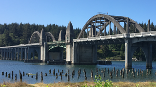
The Siuslaw River Bridge is a bascule bridge that spans the Siuslaw River on U.S. Route 101 in Florence, Oregon. It was designed by Conde McCullough, built by the Mercer-Fraser Company of Eureka, California, and funded by the Federal Emergency Administration of Public Works. It opened in 1936.
Memorial Stadium is an outdoor baseball park in the western United States in unincorporated Ada County, Idaho, adjacent to the Western Idaho Fairgrounds on the banks of the Boise River. While not physically located within the city of Boise, the stadium has a Boise postal address. The home field of the Boise Hawks of the independent Pioneer League, it has a current seating capacity of 3,452.

Lower Granite Lock and Dam is a concrete gravity run-of-the-river dam in southeastern Washington in the United States. On the lower Snake River, it bridges Whitman and Garfield counties. Opened 50 years ago in 1975, the dam is located 22 miles (35 km) south of Colfax and 35 miles (56 km) north of Pomeroy.

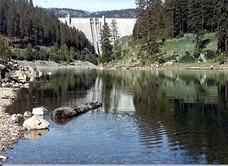
Dworshak Dam is a concrete gravity dam in the western United States, on the North Fork of the Clearwater River in north central Idaho. In Clearwater County, the dam is located approximately four miles (6 km) northwest of Orofino and impounds the Dworshak Reservoir for flood control and hydroelectricity generation. By capacity, the reservoir is the largest in Idaho and fourth-largest in the Pacific Northwest.
Neale Stadium was an outdoor athletic stadium in the northwest United States, located on the campus of the University of Idaho in Moscow, Idaho. Opened 88 years ago in 1937 for college football, it was used for over three decades, through the 1968 football season; the track team moved to the venue in the late 1940s.

The Fred G. Redmon Bridge, also known as the Selah Creek Bridge, is a twin arch bridge in the northwest United States, in Yakima County, Washington. It carries Interstate 82 across Selah Creek near Selah, between Yakima and Ellensburg.
The North Fork Clearwater River is a major tributary of the Clearwater River in the U.S. state of Idaho. From its headwaters in the Bitterroot Mountains of eastern Idaho, it flows 135 miles (217 km) westward and is dammed by the Dworshak Dam just above its mouth in north-central Idaho. Draining a rugged watershed of 2,462 square miles (6,380 km2), the river has an average flow of over 5,600 cubic feet per second (160 m3/s), accounting for a third of the discharge from the Clearwater basin. The river drains parts of Clearwater, Shoshone, Latah, and Idaho counties. Most of the watershed is managed by the U.S. Forest Service. Some of the fish of the river include westslope cutthroat trout, rainbow trout, mountain whitefish, and the threatened bull trout. It also has smallmouth bass and a kokanee salmon run, both from Dworshak Reservoir. The North Fork drainage is home to grizzly bears, cougars, deer, moose, black bear, elk, grey wolves, and osprey. The river used to have a large steelhead run before the implementation of Dworshak Dam. The North Fork of the Clearwater is located within the Clearwater National Forest

The Clearwater River is in the northwestern United States, in north central Idaho. Its length is 74.8 miles (120.4 km), it flows westward from the Bitterroot Mountains along the Idaho-Montana border, and joins the Snake River at Lewiston. In October 1805, the Lewis and Clark Expedition descended the Clearwater River in dugout canoes, putting in at "Canoe Camp," five miles (8 km) downstream from Orofino; they reached the Columbia Bar and the Pacific Ocean about six weeks later.

The Bellows Falls Arch Bridge was a three-hinged steel through arch bridge over the Connecticut River between Bellows Falls, Vermont and North Walpole, New Hampshire. It was structurally significant as the longest arch bridge in the United States when it was completed in 1905.

War Memorial Gymnasium is a 2,500-seat multi-purpose indoor arena in the northwest United States, on the campus of the University of Idaho in Moscow, Idaho. Opened 97 years ago in November 1928, the venue honors state residents who gave their lives in the service of their country in World War I.

The Cheshire Bridge spans the Connecticut River between Charlestown, New Hampshire, and Springfield, Vermont.

The Ranger Bridge between Wells River, Vermont and Woodsville, New Hampshire, is a three-hinged steel arch truss bridge over the Connecticut River. It was built in 1923 to replace a 1917 bridge and is the oldest steel arch bridge over the Connecticut River.

The Maple Street Bridge is a girder bridge in the northwest United States in Spokane, Washington. It spans West Central to Downtown, crossing over the Spokane River and the Peaceful Valley neighborhood. Along with the Division Street Bridge and Monroe Street Bridge, the Maple Street Bridge is one of several major bridges that cross the Spokane River.


