Related Research Articles

In geography, a plain, commonly known as flatland, is a flat expanse of land that generally does not change much in elevation, and is primarily treeless. Plains occur as lowlands along valleys or at the base of mountains, as coastal plains, and as plateaus or uplands. Plains are one of the major landforms on earth, being present on all continents and covering more than one-third of the world's land area. Plains in many areas are important for agriculture. There are various types of plains and biomes on them.

A valley is an elongated low area often running between hills or mountains, which will typically contain a river or stream running from one end to the other. Most valleys are formed by erosion of the land surface by rivers or streams over a very long period. Some valleys are formed through erosion by glacial ice. These glaciers may remain present in valleys in high mountains or polar areas.

Geomorphology is the scientific study of the origin and evolution of topographic and bathymetric features created by physical, chemical or biological processes operating at or near Earth's surface. Geomorphologists seek to understand why landscapes look the way they do, to understand landform and terrain history and dynamics and to predict changes through a combination of field observations, physical experiments and numerical modeling. Geomorphologists work within disciplines such as physical geography, geology, geodesy, engineering geology, archaeology, climatology, and geotechnical engineering. This broad base of interests contributes to many research styles and interests within the field.
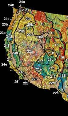
In the context of physical geography, the Intermontane Plateaus is one of eight physiographic regions of the contiguous United States. The region consists mostly of plateaus and mountain ranges lying between the Rocky Mountains on the east and the Cascade and Sierra Nevada Mountains on the west. It is subdivided into three physiographic provinces: the Columbia Plateau in the north, the Basin and Range Province in the central and southwestern portions, and the Colorado Plateau in the southeast. In turn, each of these provinces are each subdivided into a number of physiographic sections.

In geomorphology and geology, a peneplain is a low-relief plain formed by protracted erosion. This is the definition in the broadest of terms, albeit with frequency the usage of peneplain is meant to imply the representation of a near-final stage of fluvial erosion during times of extended tectonic stability. Peneplains are sometimes associated with the cycle of erosion theory of William Morris Davis, but Davis and other workers have also used the term in a purely descriptive manner without any theory or particular genesis attached.

Walther Penck was a geologist and geomorphologist known for his theories on landscape evolution. Penck is noted for criticizing key elements of the Davisian cycle of erosion, concluding that the process of uplift and denudation occur simultaneously, at gradual and continuous rates. Penck's idea of parallel slope retreat led to revisions of Davis's cycle of erosion.
The Nashville Basin, also known as the Central Basin, is a term often used to describe the area surrounding Murfreesboro, Tennessee, in which Nashville is located. The Central Basin was caused by an uplifting which produced a dome known as the Nashville Dome. The Nashville Dome is evidenced by the underlying rock strata that all dip downwards away from Nashville. The uplifting of the Nashville Dome fractured overlying strata, making it more easily eroded and thus the "dome" resulted in a "basin". Uplifted strata in the center of a geological dome have higher potential erosive energy than the surrounding strata, because they are physically higher. Erosion thus acts on the uplifted area at a greater rate than on the surrounding flat-lying area, creating a low area, i.e. a basin. This area is more correctly referred to as the "Central Dome" of Tennessee.
Denudation is the geological processes in which moving water, ice, wind, and waves erode the Earth's surface, leading to a reduction in elevation and in relief of landforms and landscapes. Although the terms erosion and denudation are used interchangeably, erosion is the transport of soil and rocks from one location to another, and denudation is the sum of processes, including erosion, that result in the lowering of Earth's surface. Endogenous processes such as volcanoes, earthquakes, and tectonic uplift can expose continental crust to the exogenous processes of weathering, erosion, and mass wasting. The effects of denudation have been recorded for millennia but the mechanics behind it have been debated for the past 200 years and have only begun to be understood in the past few decades.
Tectonic uplift is the geologic uplift of Earth's surface that is attributed to plate tectonics. While isostatic response is important, an increase in the mean elevation of a region can only occur in response to tectonic processes of crustal thickening, changes in the density distribution of the crust and underlying mantle, and flexural support due to the bending of rigid lithosphere.
The geographic cycle, or cycle of erosion, is an idealized model that explains the development of relief in landscapes. The model starts with the erosion that follows uplift of land above a base level and ends, if conditions allow, in the formation of a peneplain. Landscapes that show evidence of more than one cycle of erosion are termed "polycyclical". The cycle of erosion and some of its associated concepts have, despite their popularity, been a subject of much criticism.
In geology and geomorphology a pediplain is an extensive plain formed by the coalescence of pediments. The processes through which pediplains forms is known as pediplanation. The concepts of pediplain and pediplanation were first developed by geologist Lester Charles King in his 1942 book South African Scenery. The concept gained notoriety as it was juxtaposed to peneplanation.
Attrition is the process of erosion that occurs during rock collision and transportation. The transportation of sediment chips and smooths the surfaces of bedrock; this can be through water or wind. Rocks undergoing attrition erosion are often found on or near the bed of a stream. Attrition is also partially responsible for turning boulders into smaller rocks and eventually to sand.
Well integrity, in regard to oil wells, is defined by NORSOK D-010 as the "“Application of technical, operational and organizational solutions to reduce risk of uncontrolled release of formation fluids throughout the life cycle of a well”. There are various facets to well integrity, including accountability/responsibility, well operating processes, well service processes, tubing/annulus integrity, tree/wellhead integrity and testing of safety systems.

Dissolved load is the portion of a stream's total sediment load that is carried in solution, especially ions from chemical weathering. It is a major contributor to the total amount of material removed from a river's drainage basin, along with suspended load and bed load. The amount of material carried as dissolved load is typically much smaller than the suspended load, though this is not always the case, particularly when the available river flow is mostly harnessed for purposes such as irrigation or industrial uses. Dissolved load comprises a significant portion of the total material flux out of a landscape, and its composition is important in regulating the chemistry and biology of the stream water.

Terraces can be formed in many ways and in several geologic and environmental settings. By studying the size, shape, and age of terraces, one can determine the geologic processes that formed them. When terraces have the same age and/or shape over a region, it is often indicative that a large-scale geologic or environmental mechanism is responsible. Tectonic uplift and climate change are viewed as dominant mechanisms that can shape the earth’s surface through erosion. River terraces can be influenced by one or both of these forcing mechanisms and therefore can be used to study variation in tectonics, climate, and erosion, and how these processes interact.
In geology, the term exhumation refers to the process by which a parcel of rock, approaches Earth's surface.

In geology and geomorphology a planation surface is a large-scale surface that is almost flat with the possible exception of some residual hills. The processes that form planation surfaces are labelled collectively planation and are exogenic. Planation surfaces are planated regardless of bedrock structures. On Earth, they constitute some of the most common landscapes. Geological maps indicate that planation surfaces may comprise 65% of the landscapes on Saturn's largest moon, Titan, which hosts a hydrological cycle of liquid methane. Peneplains and pediplains are types of planation surfaces planated respectively by "peneplanation" and "pediplanation". In addition to these there are planation surfaces proposed to be formed by cryoplanation, marine processes, areal glacial erosion and salt weathering. The term planation surface is often preferred over others because some more specific planation surface types and processes remain controversial. Etchplains are weathered planation surfaces.

The paleic surface or palaeic surface is an erosion surface of gentle slopes that exist in South Norway. Parts of it are a continuation of the Sub-Cambrian peneplain and Muddus Plains found further east or equivalent to the strandflat coastal plains of Norway. Hardangervidda, a particularly flat and elevated part of the Paleic surface formed in the Miocene at sea level.
Sten Rudberg was a Swedish geologist and geomorphologist. He was the son of Gunnar Rudberg. Sten Rudberg was appointed chair professor of the Göteborg University in 1958 after incumbent professor Karl-Erik Bergsten moved to Lund University. In 1959 Rudberg was elected into the Royal Society of Sciences and Letters in Gothenburg. Subsequently, in 1961 Rudberg's professorship was transformed into a professorship in Physical geography. In 1964 Rudberg went to head the department of Physical geography after the Geography department of the Göteborg University was dissolved and Human geography formed its own department. Rudberg remained professor in Gothenburg until 1984.

Aspledon Undae is one of the named northern circumpolar dune fields in the vicinity of Planum Boreum, the Martian North pole. It is named after one of the classical albedo features on Mars. Its name was officially approved by the International Astronomical Union (IAU) on 20 March 2007. Its name is Greek, and derives from the name of a town in Boeotia, Ancient Greece, which, in turn, took its name from Aspledon, son of Poseidon, the ancient Greek god of the sea. The dunes of Aspledon Undae extend from latitude 71.47°N to 75.14°N and from longitude 305.83°E to 315.04°E. Its centre is located at latitude 73.06°N, longitude 309.65°E (50.35°W), and has a diameter of 215.2 km.
References
- ↑ Jones, David K.C. (2004). "Cycle of erosion". In Goudie, A.S. (ed.). Encyclopedia of Geomorphology. pp. 244–248.
| | This erosion article is a stub. You can help Wikipedia by expanding it. |