
The National Highway is a system of roads connecting all mainland states and territories of Australia, and is the major network of highways and motorways connecting Australia's capital cities and major regional centres.

Highways in Australia are generally high capacity roads managed by state and territory government agencies, though Australia's federal government contributes funding for important links between capital cities and major regional centres. Prior to European settlement, the earliest needs for trade and travel were met by narrow bush tracks, used by tribes of Indigenous Australians. The formal construction of roads began in 1788, after the founding of the colony of New South Wales, and a network of three major roads across the colony emerged by the 1820s. Similar road networks were established in the other colonies of Australia. Road construction programs in the early 19th century were generally underfunded, as they were dependent on government budgets, loans, and tolls; while there was a huge increase in road usage, due to the Australian gold rushes. Local government authorities, often known as Road Boards, were therefore established to be primarily responsible for funding and undertaking road construction and maintenance. The early 1900s saw both the increasingly widespread use of motorised transportation, and the creation of state road authorities in each state, between 1913 and 1926. These authorities managed each state's road network, with the main arterial roads controlled and maintained by the state, and other roads remaining the responsibility of local governments. The federal government became involved in road funding in the 1920s, distributing funding to the states. The depression of the 1930s slowed the funding and development of the major road network until the onset on World War II. Supply roads leading to the north of the country were considered vital, resulting in the construction of Barkly, Stuart, and Eyre Highways.

The Pacific Highway is a 780-kilometre-long (485 mi) national highway and major transport route along the central east coast of Australia, with the majority of it being part of Australia's Highway 1. It no longer includes former sections of the highway between Brunswick Heads and Brisbane that have been legally renamed Pacific Motorway or Gold Coast Highway. As such, the highway stops short of the Queensland border near the Gold Coast.

The Mitchell Highway is a state highway located in the central and south western regions of Queensland and the northern and central western regions of New South Wales in Australia. The southern part of the Mitchell Highway forms part of the National Highway A32 corridor, which stretches from Sydney to Adelaide via Dubbo and Broken Hill. The Mitchell Highway also forms part of the shortest route between Sydney and Darwin, via Bourke and Mount Isa; making it an important road link for the transport of passengers and freight for regional New South Wales and Queensland.
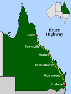
The Bruce Highway is a major highway in Queensland, Australia. Commencing in the state capital, Brisbane, it passes through areas close to the eastern coast on its way to Cairns in Far North Queensland. The route is part of the Australian National Highway and also part of Highway 1, the longest highway route in Australia. Its length is approximately 1,679 kilometres (1,043 mi); it is entirely sealed with bitumen. The highway is named after a popular former Queensland and federal politician, Harry Bruce. Bruce was the state Minister for Works in the mid-1930s when the highway was named after him. The highway once passed through Brisbane, but was truncated at Bald Hills when the Gateway Motorway became National Highway 1 upon its opening in December 1986.

Cunnamulla is a town and a locality in the Shire of Paroo, Queensland, Australia. It is 206 kilometres (128 mi) south of Charleville, and approximately 750 kilometres (470 mi) west of the state capital, Brisbane. In the 2016 census, Cunnamulla had a population of 1,140 people.
Augathella is a rural town and locality in the Shire of Murweh, Queensland, Australia. In the 2016 census, Augathella had a population of 449 people.

The Warrego Highway is located in southern Queensland, Australia. It connects coastal centres to the south western areas of the state, and is approximately 715 km in length. It takes its name from the Warrego River, which is the endpoint of the highway. The entire highway is part of the National Highway system linking Darwin and Brisbane: formerly National Highway 54, Queensland began to convert to the alphanumeric system much of Australia had adopted in the early-2000s and is now designated as National Highway A2.

The Brisbane Valley Highway is a state highway in Queensland. It links the Warrego Highway near Ipswich and the D'Aguilar Highway about 4 km (2 mi) north of Harlin. Its direction follows the approximate course of the Brisbane River. It is part of State Route A17, duplexing with the D'Aguilar Highway to Nanango and then becomes the Burnett Highway. State Route 85 is duplexed with the Brisbane Valley Highway from Esk to the D'Aguilar Highway.

The Pacific Motorway is a motorway in Australia between Brisbane, Queensland, and Brunswick Heads, New South Wales, through the New South Wales–Queensland border at Tweed Heads.

South East Queensland (SEQ) is a bio-geographical, political, and administrative region of the state of Queensland in Australia, which contains more than 3.6 million people out of the state's population of 5.1 million. The area covered by South East Queensland varies, depending on the definition of the region, though it tends to include Queensland's three largest cities: the capital city Brisbane; the Gold Coast; and the Sunshine Coast. Its most common use is for political purposes, and covers 22,420 square kilometres (8,660 sq mi) and incorporates 11 local government areas, extending 240 kilometres (150 mi) from Noosa in the north to the Gold Coast and New South Wales border in the south, and 140 kilometres (87 mi) west to Toowoomba.
The Gateway Motorway is a major tolled motorway in Brisbane, Queensland, Australia which includes the Sir Leo Hielscher Bridges. The motorway is operated by toll road operator Transurban.

The M7 runs from the junction of Ipswich Road and Granard Road to the M2 Logan Motorway interchange. It is then signed M2 until the junction of the Warrego Highway and the Cunningham Highway between Brisbane and Ipswich in South East Queensland, Australia.

Anstead is an outer western suburb in the City of Brisbane, Queensland, Australia. In the 2016 census, Anstead had a population of 1,509 people.

The Gold Coast is the largest regional city and fastest growing city in Australia. As a result, the Gold Coast has a wide range of public and private transport options from cars and bikes to buses, heavy rail and light rail. The car is the dominant mode of transport in the city with an extensive arterial road network that connects the standard residential streets with major suburbs and motorways.
The road transport of Brisbane, Australia consists of a network of highways, freeways and motorways. Some motorways have tolls applied.
Monkland is a locality in the Gympie Region, Queensland, Australia.
The Kenmore Bypass is a proposal for a major road linking Moggill Road, Pinjarra Hills, with the Centenary Motorway, Kenmore, in Brisbane, Australia. The Proposed Bypass will be 3.3 kilometres (2.1 mi) in length. Since the 1960s a corridor of land has been set aside for a bypass. This is where the Kenmore bypass will be located if the plans go ahead. The Bypass is stage 1 of the planned Moggill Pocket Arterial Road corridor.
This is a list of freeways or freeway grade roads. in Australia, sorted by states and territories and their corresponding routes. This list includes tollways / toll roads such as the CityLink freeway system in Melbourne. This list has over 120 entries. The jurisdiction in Australia without freeways is the Northern Territory and Jervis Bay Territory. New South Wales has the largest and densest freeway network in Australia followed by Victoria and then Queensland

The Toowoomba Bypass, known as Toowoomba Second Range Crossing during planning and construction, is a 41 km (25 mi) grade separated, dual carriageway bypass and partial ring road constructed to the north and west of Toowoomba, Queensland. Construction commenced in April, 2016. It opened to traffic on 8 September 2019.