A geographic coordinate system is a coordinate system that enables every location on Earth to be specified by a set of numbers, letters or symbols. The coordinates are often chosen such that one of the numbers represents a vertical position and two or three of the numbers represent a horizontal position; alternatively, a geographic position may be expressed in a combined three-dimensional Cartesian vector. A common choice of coordinates is latitude, longitude and elevation. To specify a location on a plane requires a map projection.
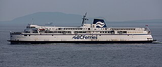
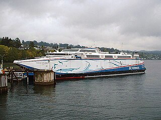
Departure Bay. To the right of the image is Newcastle Island. A BC Ferries ship can also be seen entering the bay, with two other ships already docked at the terminal.
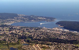
Departure Bay is a bay in central Nanaimo, British Columbia, on the east coast of Vancouver Island. The surrounding neighbourhood is also referred to as "Departure Bay"—once a settlement of its own, it was amalgamated into the City of Nanaimo in the 1970s (see the history section).
Vancouver Island is in the northeastern Pacific Ocean. It is part of the Canadian province of British Columbia. The island is 460 kilometres (290 mi) in length, 100 kilometres (62 mi) in width at its widest point, and 32,134 km2 (12,407 sq mi) in area. It is the largest island on the West Coast of North America.
Geography
Jesse Island (with navigational marker).
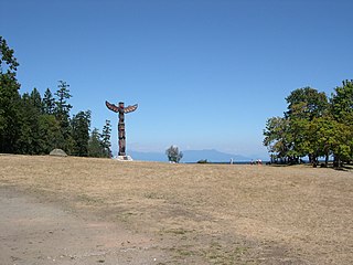
The bay is framed to the west by Vancouver Island and to the south-east by Newcastle Island, a provincial marine park with a long history of mining, quarrying, herring salteries and tourism. Jesse Island (9 acres or 3.6 hectares) and the smaller Brandon Island are located near the northern shore of the bay. Both islands, though quite small, have varied histories; Brandon Island being notable for a history of Japanese fish canneries and salteries. In 1853 both islands were named after sailors on HMS Virago. Snake Island is a located just outside the mouth of the bay.
Newcastle Island is a provincial park located on a small island off the coast of Nanaimo, British Columbia, Canada.
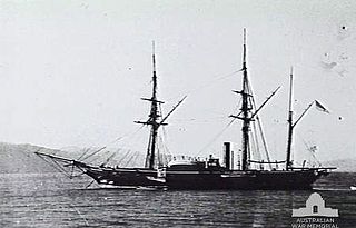
HMS Virago was a 1669-ton, Royal Navy 6 gun 1st class paddle sloop launched on 25 July 1842 from Chatham Dockyard.
The "Departure Bay" neighbourhood surrounds most of the bay; though sometimes the northeastern shoreline may be referred to as "Hammond Bay." The BC Ferry terminal (itself referred to simply as "Departure Bay") is on the southern shore of the bay. The image above-right shows a ferry which has just entered the bay turning towards the terminal.
British Columbia Ferry Services Inc., operating as BC Ferries (BCF), is a former provincial Crown corporation, now operating as an independently managed, publicly owned company. BC Ferries provides all major passenger and vehicle ferry services for coastal and island communities in the Canadian province of British Columbia. Set up in 1960 to provide a similar service to that provided by the Black Ball Line and the Canadian Pacific Railway, which were affected by job action at the time, BC Ferries has become the largest passenger ferry line in North America and the second largest in the world, boasting a fleet of 35 vessels with a total passenger and crew capacity of over 27,000, serving 47 locations on the B.C. coast.
History of the area
The earliest settlers in the region were a First Nations group known as the Snuneymuxw. It was reported in 1970 that evidence showed that the area had been inhabited for at least the whole of the last 2000 years relatively consistently.[1]
The area was first explored by the Spanish between the 1770s and 1790s. The whole area, including Northumberland Channel, Nanaimo Harbour, and Departure Bay were named "Bocas de Winthuysen" by a Spanish naval officer, Francisco de Eliza, in 1791. The area was nonetheless referred to by the local native population as "Stil'ilup". The bay and surrounding area received an approximation of its present English moniker in approximately 1852: "Departure Harbour;" responsible for the naming were representatives of the Hudson's Bay Company. Later, in approximately 1855, maps were published showing the modern "Departure Bay."[1][2]
Spain, officially the Kingdom of Spain, is a country mostly located in Europe. Its continental European territory is situated on the Iberian Peninsula. Its territory also includes two archipelagoes: the Canary Islands off the coast of Africa, and the Balearic Islands in the Mediterranean Sea. The African enclaves of Ceuta, Melilla, and Peñón de Vélez de la Gomera make Spain the only European country to have a physical border with an African country (Morocco). Several small islands in the Alboran Sea are also part of Spanish territory. The country's mainland is bordered to the south and east by the Mediterranean Sea except for a small land boundary with Gibraltar; to the north and northeast by France, Andorra, and the Bay of Biscay; and to the west and northwest by Portugal and the Atlantic Ocean.
Francisco de Eliza y Reventa was a Spanish naval officer, navigator, and explorer. He is remembered mainly for his work in the Pacific Northwest. He was the commandant of the Spanish post in Nootka Sound on Vancouver Island, and led or dispatched several exploration voyages in the region, including the Strait of Juan de Fuca and the Strait of Georgia.
The Hudson's Bay Company is a Canadian retail business group. A fur trading business for much of its existence, HBC now owns and operates retail stores in Canada, the United States, and parts of Europe including Belgium, the Netherlands, and Germany. The company's namesake business division is Hudson's Bay, commonly referred to as The Bay. Other divisions include Galeria Kaufhof, Home Outfitters, Lord & Taylor and Saks Fifth Avenue. HBC's head office is currently located in Brampton, Ontario. The company is listed on the Toronto Stock Exchange under the symbol "HBC".
In approximately 1861, the first known settlers of European origin made Departure Bay their home; they were William Joseph Hughes, Samuel Harris, and John and Barbara Christie. To obtain land they used what was known as "pre-emption," a historical method the Crown used to quickly sell previously un-surveyed land. In the late 1860s, coal was discovered in the Wellington area, and Departure Bay became the terminus of the rail system shipping coal from the mines. Soon, supporting offices and wharves appeared in the area. Later, in the 1870s, coal was discovered closer to the bay itself, and the Vancouver Coal Company set up further operations in the area. As an example of the significance of this area and its commercial operations, the first phone in British Columbia was set up connecting a coal wharf in Departure Bay with the mining operations in nearby Wellington. During the development of Departure Bay, many mining companies were active in the area, including the Departure Bay Mining Company, the Harewood Coal Company, and the aforementioned Vancouver Coal Company. The Hudson's Bay Company also operated mines in the area. Early in the modern history of Departure Bay, in the decades after the first settlements in the 1860s, the area was relatively populous, due in-part to the surrounding mining operations. When the mining operations later ceased (moving further away to Extension), what was once a "booming little port" became "virtually uninhabited."[1] Until as late as the 1940s, the area remained a relatively insignificant neighbour of Nanaimo.[1]
In 1892—after realizing that irrespective of the new plant in the Northfield area, demand was still increasing—the Hamilton Powder Company built an explosives (mainly black powder, dynamite, and stumping powder) manufacturing plant on the shore of Departure Bay. The production of black powder was relatively dangerous, and the death of employees was frequently the result of accidents.
Less than a month later, on the morning of January 14, 1903, the deadliest explosion ever, in terms of loss of life, occurred when two massive explosions rocked the Departure Bay works. The ignition took place in the drying and weighing room where the gun cotton was stored. That concussion then set off the gelignite building 400 feet away, where a large quantity of high explosives was stored. Both buildings were wrecked and twelve men were killed. Their bodies were unidentifiable. ... [This] explosion at the Departure Bay powder works launched a piece of railway track 80 metres through the air with such force that it wrapped itself around a tree ... like a corkscrew.
Between 1974 and 1975, the community of Departure Bay was amalgamated with the City of Nanaimo, based on a popular vote of only 52 percent in favour. In actuality, 61 percent of Departure Bay residents voted against the change; nonetheless, the greater vote from the populace of Nanaimo (which was to see its personal taxes lowered as a result—while Departure Bay's would be likewise increased) overcame the resistance.
The earliest ferries to use the port were local ships, traveling short routes between locations in the area, including Nanaimo, Departure Bay, and Newcastle Island. The first major ferry operation in the area was that of the Canadian Pacific Navigation Company, which maintained a route between Vancouver Island and the Lower Mainland between 1893 and 1901. In 1901, the Canadian Pacific Navigation Company was purchased by the Canadian Pacific Railway. The route stayed in operation as the sole service until the 1950s, when the Black Ball Ferries of Captain Alexander M. Peabody's Puget Sound Navigation Company began to service the area between Departure Bay and Horseshoe Bay with the ships Kahloke and Chinook. In the late 1950s, during a time of labour unrest in the industry, Premier Bennett started a governmental ferry service, then known as the British Columbia Toll Authority Ferry System.[4] Departure Bay remained being served by the Black Ball Line until it was bought by the government ferry corporation in December 1961.
This section needs expansion. You can help by adding to it.(December 2009)
Since the earliest European settlements, the area has been a relatively busy port, for itself and the surrounding communities. The Trans-Canada Highway on Vancouver Island terminates in the north at Departure Bay, where a B.C. Ferry terminal is located. Ferries out of Departure Bay connect the Trans-Canada Highway to the Lower Mainland at Horseshoe Bay. As a major connector to Vancouver, Departure Bay is the most heavily used Island terminal north of Swartz Bay. Whenever necessary, Departure Bay can act as a backup dock for the ferry to Gabriola Island. Between 1990 and 1997, Departure Bay was also the Island terminus for the "Mid-Island Express" route to Tsawwassen, before being replaced by the newer Duke Point terminal.
Historically, before the BC Ferry Corporation took over services, Departure Bay was served by the Black Ball FerriesKahloke and Chinook. See the section on the history of the ferries in the area above.
This section needs expansion. You can help by adding to it.(December 2009)
Related Research Articles
Nanaimo is a city on the east coast of Vancouver Island in British Columbia, Canada. It is known as "The Harbour City". The city was previously known as the "Hub City", which has been attributed to its original layout design where the streets radiated out from the shoreline like the spokes of a wagon wheel, as well as its generally centralized location on Vancouver Island. Nanaimo is also the headquarters of the Regional District of Nanaimo.
Highway 19A, known locally as the Oceanside Route or the Old Island Highway, is a provincial highway in British Columbia, Canada. It runs along two former sections of Highway 19 on Vancouver Island, within Nanaimo and between Craig's Crossing and Campbell River. The section of Highway 19A between Craig's Crossing and Campbell River is 123 km (76 mi) long, and the Nanaimo alignment covers 12 km (7 mi). The highway was established after Highway 19 was realigned to a new road in 1953.
Gabriola Island is one of the Gulf Islands in the Strait of Georgia in British Columbia (BC), Canada. It is about 5 kilometres (3.1 mi) east of Nanaimo on Vancouver Island, to which it is linked by a 20-minute ferry service. It has a land area of about 57.6 square kilometres (22.2 sq mi) and a resident population of slightly over 4,000.
The MV Queen of New Westminster is a Canadian roll-on, roll-off passenger ferry operated by BC Ferries.
MV Queen of Nanaimo was a Burnaby-class passenger vessel operated by BC Ferries.
Robert Dunsmuir was a Scottish-Canadian coal mine developer, owner and operator, railway developer, industrialist and politician in British Columbia.
Cassidy, British Columbia is located south of Nanaimo on Vancouver Island and is home to the Ray Collishaw Air Terminal, Nanaimo's only airfield. It is home to farms and is generally rural. Its proximity to Nanaimo means it provides a short commute for those looking to live away from town. Its 2008 population was 1,002 people.
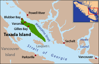
Texada Island is the largest island in the Strait of Georgia of British Columbia, Canada. Its northern tip is located about 8 kilometres (5.0 mi) southwest of the city of Powell River and west of the Sechelt Peninsula on the Sunshine Coast. A former mining and logging area, the island still has a few quarries and old logging roads. It is the largest of the Northern Gulf Islands at some 50 kilometres in length and 10 kilometres (6.2 mi) in width, with its length aligned along a northwest-southeast axis. The island is 300.45 square kilometres in land area and had a population of 1,053 in the 2011 census (1,107 in 2006, 1,129 in the 2001 census). The main settlements are Gillies Bay, Blubber Bay and Van Anda.
The K-class ferries are a group of similarly designed ferries operated by both BC Ferries and TransLink in British Columbia, Canada.
The PacifiCat class of fast ferries was operated from 1999 to 2000 by BC Ferries in British Columbia, Canada. Three PacifiCat catamarans were built between 1996 and 2000 as part of a major public project which ultimately failed: PacifiCat Explorer, PacifiCat Discovery, and PacifiCat Voyager. Explorer and Discovery were briefly used for revenue service between Horseshoe Bay in West Vancouver and Departure Bay in Nanaimo. The third ship in the class, PacifiCat Voyager, was completed but never entered the BC Ferries fleet. The PacifiCat project started in June, 1994 with an estimated total cost of $210 million. By the time the ships were finished, it had actually cost $463 million. A 1999 report by the Auditor-General of British Columbia concluded that the fast ferry project had been beset by "significant breakdowns in both governance and risk management."
Earls Cove is a small settlement located on Jervis Inlet in the Sunshine Coast region of British Columbia. It is a terminal for the BC Ferries route across the inlet to Saltery Bay, linking the Lower Sunshine Coast with the Upper Sunshine Coast. Earls Cove is the at the north end of the Sechelt Peninsula and on the east side of the mouth of Jervis Inlet, adjacent to Agamemnon Channel, across which is Nelson Island.
Howe Sound is a roughly triangular sound, or more precisely a network of fjords situated immediately northwest of Vancouver.
The Tsawwassen Ferry Terminal is an approximately 23 ha major transportation facility in Delta, British Columbia. It is located at the southwestern end of an approximately 3 km (2 mi) man-made causeway that juts out into the Strait of Georgia off the mainland at Tsawwassen and is less than approximately 500 m (550 yd) from the 49th parallel, the Canada–United States border. The terminal is part of the BC Ferry system, as well as part of Highway 17. It is also the largest ferry terminal in North America.
Asbury Park was a high-speed coastal steamer built in Philadelphia, and intended to transport well-to-do persons from New York to summer homes on the New Jersey shore. This vessel was sold to West Coast interests in 1918, and later converted to an automobile ferry, serving on various routes San Francisco Bay, Puget Sound and British Columbia. This vessel was known by a number of other names, including City of Sacramento, Kahloke, Langdale Queen, and Lady Grace.
The MV Quinitsa is an automobile ferry operated by BC Ferries. It was built in 1977 by Vancouver Shipyards in Vancouver, British Columbia. The ferry was originally part of the Ministry of Transportation and Highways' (MoT) saltwater ferry fleet until 1985, when the MoT's saltwater ferries—including Quinitsa—were transferred to BC Ferries.
Duke Point is a major ferry terminal owned and operated by BC Ferries that provides ferry service across the Strait of Georgia to Tsawwassen. Duke Point is the only major terminal in the BC Ferries system without a public transit connection.
Departure Bay is a major ferry terminal owned and operated by BC Ferries that provides ferry service across the Strait of Georgia to Horseshoe Bay in West Vancouver.
↑ Pethick, Derek (1980). The Nootka Connection: Europe and the Northwest Coast 1790–1795. Vancouver: Douglas & McIntyre. pp.54–55. ISBN0-88894-279-6.
↑ Davidson, Carole. Historic Departure Bay... Looking Back. 2006. Victoria, BC: Rendezvous Historical Press. This contains a photo of the railway tie, showing it wrapped once wholly around the tree and almost again, for a nearly 720° bend.
This page is based on this Wikipedia article Text is available under the CC BY-SA 4.0 license; additional terms may apply. Images, videos and audio are available under their respective licenses.