Wellington, British Columbia

Last updated

Wellington
Canada British Columbia location map 2.svg
Red pog.svg
Wellington
Location of Wellington in British Columbia
Coordinates: 49°12′28″N124°00′55″W / 49.20778°N 124.01528°W / 49.20778; -124.01528
CountryFlag of Canada (Pantone).svg  Canada
Province Flag of British Columbia.svg  British Columbia
Region Vancouver Island
Regional District Nanaimo
Elevation
115 m (377 ft)
Population
 (2006)
  Total3,935 (Diver Lake)
  Density988.1/km2 (2,559/sq mi)
Time zone UTC-8 (PST)
  Summer (DST) UTC-7 (PDT)
Area codes 250, 778, 236, & 672
Highways BC-19.svg Hwy 19
Website Official website

Wellington, formerly a separate district and town, is a neighbourhood of north Nanaimo, on the east coast of southern Vancouver Island, British Columbia. [1]

Contents

First Nations & European settlement

Wellington was part of the traditional territories of the Sneneymuxw and Nanoose First Nations, who coexisted with European arrivals. The district was likely named in the 1850s following the 1852 death of Arthur Wellesley, 1st Duke of Wellington. Prior to 1869, few settlers inhabited the areas around Brannen, Long, and Diver lakes. [2]

Dunsmuir discovery

Opened around 1860 by the Hudson's Bay Company (HBC), Douglas Mine, in today's downtown Nanaimo, was the first coalmine in the region. While fishing about 8 kilometres (5 mi) northwest at Diver Lake in 1869, former HBC employee Robert Dunsmuir observed evidence of coal deposits, in what he would call the Wellington seam. [3] [4] The location was just beyond the northern boundary of the Vancouver Coal Mining and Land Company's property, acquired from the HBC in 1862. [2]

Neighbourhoods

In the early 1890s, the population peaked at over 5,000, larger than Nanaimo at the time. By the late 1890s, the mines were nearly exhausted, and mining activity had shifted to Extension. [5]

Wellington

Coalmine

In partnership with Royal Navy Lieutenant Wadham Nestor Diggle, Dunsmuir received a mining lease in 1871 for an area south of Long Lake, defined by boundaries from its shores of 1.2 kilometres (0.7 mi) westward, 1.4 kilometres (0.9 mi) eastward, and 0.8 kilometres (0.5 mi) southward. [6]

In 1872, the two principals, with junior partners, obtained a 1,032-acre (4.18 km2) Crown grant of land largely covering the mining lease, but with the northern boundary extended to capture the north shore of Long Lake. [7] The partners established Dunsmuir, Diggle & Company and developed the Wellington Collieries. Mining commenced west of Diver Lake. [8]

In 1877, labour disputes led to violent confrontations between strikers and strikebreakers. The BC government declared martial law sending in troops to restore order. [4] The next year, sabotage on a tramway caused the horrific death of a Chinese employee. [9] In 1879, 11 miners died in an explosion of coal dust or by inhaling the resulting toxic gases. [10] Around this time, Dunsmuir bought out two of his partners. [4] [11] The next year, 75 died in another explosion. [12] In 1883, Dunsmuir bought out Diggle, the remaining partner. [11]

In 1910, Sir William Mackenzie purchased all the Dunsmuir mines through his Canadian Collieries (Dunsmuir). [13]

Railways

By 1873, the company replaced the wagon road [4] with a horse-drawn wooden tramway, superseded the next year [14] by a 0.76-metre (2 ft 6 in) wide narrow gauge railway to cover the 7.4 kilometres (4.6 mi) to the company wharf at the northwest corner of Departure Bay, from where company steamboats transported the coal to San Francisco. At the lower elevation, a long loop in the line was needed to create an acceptable gradient. [15] [16]

Dunsmuir established the E&N Railway (E&N) that opened Victoria–Nanaimo in 1886. The next year, the E&N extended northwest to Diver Lake. [17]

Townsites

The initial town developed north of Diver Lake, along the crest of today's Jingle Pot Road. The current Nanaimo-Ladysmith School District Island ConnectEd buildings occupy the property upon which the first Wellington school opened in 1875. [2] By the early 1880s, about 100 houses existed. [15]

In 1890, the company, by then controlled by James Dunsmuir, Robert's son, created a new townsite on the south shore of Long Lake, with numbered streets (now 101–107), [2] and avenues named after important figures or places from the Duke of Wellington's career. Corunna was from the Battle of Corunna, Victoria from Queen Victoria, Wellesley from his surname, and Apsley from Apsley House.

Many buildings surviving the 1899 fire were soon relocated to Ladysmith, sold for removal, or demolished. [5]

South Wellington

Coalmine

By 1877, the South Wellington Colliery, owned by Richard D. Chandler of San Francisco, operated between Brannen and Diver lakes, not far outside the southern boundary of the Dunsmuir claim. Acquired by Dunsmuir in 1879 [18] or 1881, [11] the claim became the No. 2 Mine for Wellington. After 1882, production figures were merged. This colliery should not be confused with the one at South Wellington, an entirely different location south of Nanaimo. [4] [18]

Dunsmuir operated No. 5 1884–1900 in the vicinity. Connected to the E&N, the mine was one of the largest. An 1888 explosion killed 77 miners. [3]

On today's Landmark Crescent, Robert (Bob) Carruthers worked by hand 1942–1968 the outcrops of the Loudon mine, the final coalmining on Vancouver Island. [19]

Railway

A narrow gauge railway ran 6.9 kilometres (4.3 mi) to the company wharf at the southeast corner of Departure Bay. The circuitous track largely covered level ground. [15]

Townsite & farm

By the early 1880s, about 50 houses existed, but the community infrastructure was at Wellington proper. The 100-acre (40 ha) farm provided feed for the horses and mules used to haul ore cars at the mine site. [15]

South toward east

Dunsmuir operated No. 3 1880–1899. Connected by a tunnel, No.4 operated 1881–1897, and was used for ventilation and transporting coal. [3] An 1885 explosion in No. 4 killed four miners. [20]

East Wellington

Coalmine

Starting in 1864, members of the Westwood family homesteaded several parcels totaling 650-acre (260 ha) between Nanaimo and Wellington. In 1882, Richard Devonshire Chandler acquired the properties (which included subsurface rights), and formed the East Wellington Coal Company. The mine was near today's Maxey Rd/East Wellington Rd intersection. [18] The company built a narrow gauge railway to Departure Bay. [12] Development work was carried out, and significant quantities of coal were produced, but results were comparatively mixed. In 1893 the mine flooded and closed, and the next year the assets were acquired by [James] Dunsmuir, but little further production ensued. [18]

Present community

The area is largely small rural holdings. The volunteer fire department occupies a modern building. [18]

West Wellington

Adjacent to Dunsmuir's western boundary, Dennis Jordan of San Francisco, revived some prior work in 1895. Lacking economical transportation, the West Wellington Coal Company operation folded after a few years. In 1907, the Gilfillan Colliery acquired the coal rights, but shuttered the next year. In 1928, the Little Ash Mine ran a small operation for a few years. [18]

North Wellington

In 1925, Island Collieries, owned by King & Foster Co., opened a small operation, which Canadian Collieries acquired in 1927. Renamed Wellington Extension No. 9, the mine operated intermittently until closing in 1932. [18]

Later community overview

Wellington remained largely rural until World War II, when Nanaimo started to grow, and Wellington became an adjacent bedroom community. In the 1960s, the Wellington Improvement District amalgamated with the City of Nanaimo. Since amalgamation with Nanaimo, Wellington District is often referred to as "North Nanaimo" with only the former town site areas keeping the neighbourhood name of "Wellington".

Today's Wellington neighbourhood is often referred to as Diver Lake, Long Lake, Wellington, Rutherford, or North Nanaimo. Its lakes provide fishing and recreation, while its heritage as an old town has resulted in a diverse composition which includes residential, commercial, and industrial land. It is flanked by Nanaimo North Town Centre (formerly Rutherford Mall), Long Lake, and Country Club Mall to the north, Beban Community Center Complex to the south-east, farms to the west, and the Mostar/Boban industrial area to the northwest.

Demographics

Canada 2006 Census [21]
WellingtonNanaimoBritish Columbia
Median age37.1 years43.3 years40.8 years
Under 15 years old21.1%16%17%
Over 65 years old13%17%15%

The Wellington neighbourhood population and demographics can be approximated by using the figures for the Diver Lake Census Tract which covers the largest portion of the Wellington neighbourhood. The actual population of the Wellington neighbourhood would be slightly higher if the portions of the neighbourhood not included in the Census Tract were included. Population growth from the 2001 to 2006 was 8.1% vs 7.8% and 5.3% for the City of Nanaimo and Province of British Columbia.

See also

Footnotes

  1. "Wellington (community)". BC Geographical Names .
  2. 1 2 3 4 "The Wellingtons of Nanaimo Part 1". www.vanislehistoryexplorer.ca. 8 May 2018.
  3. 1 2 3 "Nanaimo Coal Mines". www.specproj.web.viu.ca.
  4. 1 2 3 4 5 Paterson & Basque 1999, p. 38.
  5. 1 2 Paterson & Basque 1999, p. 44.
  6. "Messrs. Dunsmuir & Diggles coal claim" (PDF). www.royalbcmuseum.bc.ca. pp. 45–61.
  7. "Dunsmuir & Diggles Crown grant title deed" (PDF). www.gov.bc.ca.
  8. "Dunsmuir & Diggles Crown grant title map" (PDF). www.gov.bc.ca.
  9. Paterson & Basque 1999, pp. 38–39.
  10. Paterson & Basque 1999, p. 39.
  11. 1 2 3 "Daily Colonist, 13 Apr 1889". www.archive.org. 1889. p. 4.
  12. 1 2 Paterson & Basque 1999, p. 42.
  13. "Daily Colonist, 26 Jun 1910". www.archive.org. 1910. p. 11.
  14. "Daily Colonist, 12 Dec 1873". www.archive.org. 1873. p. 3.
  15. 1 2 3 4 "1882–1883 BC Directory". www.bccd.vpl.ca.
  16. "The Robert Dunsmuir wharf, Departure Bay, c.1875". www.royalbcmuseum.bc.ca.
  17. "Nanaimo Daily News, 8 Jun 1887". www.newspapers.com. p. 2. ….completed the work on that extension and the construction train left on Saturday for the southern portion of the line. The Wellington Extension runs from the Nanaimo Depot to the edge of Diver Lake, at the entrance of Wellington, a distance of about 5 miles. The Wellington station will be erected close to the site of the old dancng platform….
  18. 1 2 3 4 5 6 7 "The Wellingtons of Nanaimo Part 2". www.vanislehistoryexplorer.ca.
  19. "Daily Colonist, 19 Oct 1968". www.archive.org. 1968. p. 21.
  20. Paterson & Basque 1999, p. 43.
  21. Statistics Canada (July 25, 2006). "Wellington-Diver Lake Census Tract". 2006 Census. Canada. Retrieved 2009-03-16.

Related Research Articles

<span class="mw-page-title-main">Island Rail Corridor</span> Dormant railway operation on Vancouver Island

The Island Rail Corridor, previously the Esquimalt & Nanaimo Railway, is a dormant railway operation on Vancouver Island and is the only remaining railway there after the closure of the Englewood Railway in November 2017. The Island Corridor Foundation owns the former Esquimalt & Nanaimo Railway corridor. The railway line is 225 kilometres (140 mi) in length from Victoria to Courtenay, known as the Victoria Subdivision, with a branch line from Parksville to Port Alberni known as the Port Alberni Subdivision at 64 kilometres (40 mi) in length, for a total 289 kilometres (180 mi) of mainline track. In 2006, the Island Corridor Foundation acquired the railway's ownership from the Canadian Pacific Railway.

<span class="mw-page-title-main">Robert Dunsmuir</span> Canadian businessman and politician

Robert Dunsmuir was a Scottish-born Canadian businessman and politician.

Cassidy is an unincorporated community straddling Haslam Creek. near the east coast of southern Vancouver Island, British Columbia, Canada. The location on BC Highway 19 is about 98 kilometres (61 mi) by road north-west of Victoria, and 14 kilometres (9 mi) south of Nanaimo.

Nanoose Bay is a community on the east coast of southern Vancouver Island, British Columbia, Canada. The location off BC Highway 19 is by road about 26 kilometres (16 mi) north of Nanaimo, and 16 kilometres (10 mi) south of Parksville.

Union Bay is an unincorporated community located south of Hart Creek on the east coast of central Vancouver Island, British Columbia. This Comox Valley community on BC Highway 19A is by road about 93 kilometres (58 mi) north of Nanaimo, and 14 kilometres (9 mi) south of Courtenay.

<span class="mw-page-title-main">Cumberland, British Columbia</span> Village in British Columbia, Canada

Cumberland is an incorporated village municipality east of Perseverance Creek, near the east coast of central Vancouver Island, British Columbia. The Comox Valley community is west of BC Highway 19 and is by road about 105 kilometres (65 mi) northwest of Nanaimo and 10 kilometres (6 mi) southwest of Courtenay.

<span class="mw-page-title-main">Departure Bay</span> Bay in British Columbia, Canada

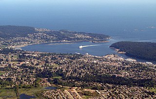
Departure Bay is a bay in central Nanaimo, British Columbia, on the east coast of Vancouver Island. The surrounding neighbourhood is also referred to as "Departure Bay" —once a settlement of its own, it was amalgamated into the City of Nanaimo in the 1970s.

<span class="mw-page-title-main">Morden Colliery Historic Provincial Park</span> Historic provincial park in Nanaimo Regional District, British Columbia

Morden Colliery Historic Provincial Park is a 4-hectare (9.9-acre) historic provincial park near the east coast of southern Vancouver Island, British Columbia. The location off BC Highway 19 is about 102 kilometres (63 mi) by road northwest of Victoria, and 10 kilometres (6 mi) south of Nanaimo.

<span class="mw-page-title-main">Bulkley Valley</span> Valley in British Columbia, Canada

The Bulkley Valley is in the northwest Central Interior of British Columbia, Canada.

Mount Sicker is in southern Vancouver Island, British Columbia. The twin summits of Big Sicker Mountain, at 716 metres (2,349 ft), and Little Sicker Mountain, at 660 metres (2,170 ft), are near Crofton, Chemainus and Duncan.

Leechtown is at the confluence of the Leech River into the Sooke River in southern Vancouver Island, British Columbia. The ghost town, off BC Highway 1 is about 59 kilometres (37 mi) by road northwest of Victoria.

<span class="mw-page-title-main">Fort Rupert</span> Place in British Columbia, Canada

Fort Rupert is the site of a former Hudson's Bay Company (HBC) fort on the east coast near the northern tip of Vancouver Island, British Columbia. The unincorporated community on Beaver Harbour is about 11 kilometres (7 mi) by road southeast of Port Hardy.

Mount Benson Elementary was a public elementary school located in the Wellington neighbourhood of Nanaimo, British Columbia and was part of School District 68 Nanaimo-Ladysmith. It was closed in 2008.

<span class="mw-page-title-main">Kitselas Canyon</span> Canyon in Kitimat-Stikine Regional District, Canada

Kitselas Canyon is a canyon carved by the Skeena River in the Skeena region of west central British Columbia, Canada. Off BC Highway 16, the landmark is by road about 185 kilometres (115 mi) west of Smithers and 20 kilometres (12 mi) northeast of Terrace.

The Wellington station located in the Wellington area of Nanaimo, British Columbia, was a flag stop on Via Rail's Dayliner service, which ended in 2011. The station is on the Southern Railway of Vancouver Island mainline. The station was named after the town of Wellington which formed around and next to the Wellington Colliery which was named after Arthur Wellesley, 1st Duke of Wellington, a leading British military and political figure in the 19th century.

Extension is an unincorporated community near the east coast of southern Vancouver Island, British Columbia. The location off BC Highway 19 is about 107 kilometres (66 mi) by road northwest of Victoria, and 10 kilometres (6 mi) south of Nanaimo.

Chase River is a river on Vancouver Island in the Canadian province of British Columbia. It discharging into the Strait of Georgia at the south end of Nanaimo Harbour. It is the namesake of the city of Nanaimo's neighbourhood of Chase River.

Nanaimo, British Columbia had four Chinatown sites beginning in the 1800s.

The Vancouver Island Coal Miners' Strike was from 1912-1914. The coal miners in the Vancouver Islands refused to go to work, in protest of unsafe working conditions and unfair treatment. They began as peaceful protests, until built up anger caused by strike-breakers, also known as scabs, ruined the effectiveness of the strike and incited aggressive behavior. The militia was forced to step in and shut down the strike.

References