Related Research Articles
Benson may refer to:

Nanaimo is a city on the east coast of Vancouver Island in British Columbia, Canada. As of the 2016 census, it had a population of 90,504. It is known as "The Harbour City". The city was previously known as the "Hub City", which has been attributed to its original layout design where the streets radiated out from the shoreline like the spokes of a wagon wheel, as well as its generally centralized location on Vancouver Island. Nanaimo is also the headquarters of the Regional District of Nanaimo.

Ladysmith, originally Oyster Harbour, is a town located on the 49th parallel north on the east coast of Vancouver Island, British Columbia, Canada. The local economy is based on forestry, tourism, and agriculture. A green hill location adjacent to a sheltered harbour forms the natural geography of the community.
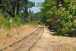
The Southern Railway of Vancouver Island is 234 kilometres (145 mi) in length, and is the only remaining railway on Vancouver Island, after the formal closure of the Englewood Railway in November 2017. The Southern Railway's railroad runs from Victoria to Courtenay, with a branch line from Parksville to Port Alberni. In 2006, the Island Corridor Foundation acquired the railway's ownership from the Canadian Pacific Railway and RailAmerica.
Oak Bay is a municipality incorporated in 1906 that is located on the southern tip of Vancouver Island, in the Canadian province of British Columbia, Canada. A member municipality of the Capital Regional District, it is a community east of and adjacent to the city of Victoria. It is one of the 13 municipalities of Greater Victoria.

Crofton, British Columbia, is a small coastal town that is part of the District of North Cowichan on southern Vancouver Island in British Columbia. The town has a population of 1,373 people as of 2016. It is about 74 km north of Victoria. The town was establish in 1902 to accommodate a smelter for the copper being mined at nearby Mount Sicker, and was named after Henry Croft, the mine owner. The worldwide drop in copper prices in 1907 saw the smelter shut down in 1908, and the town slowed down. A pulp and paper mill was built in town in 1956, giving new life to the town. Crofton also houses a BC Ferries terminal to Salt Spring Island.
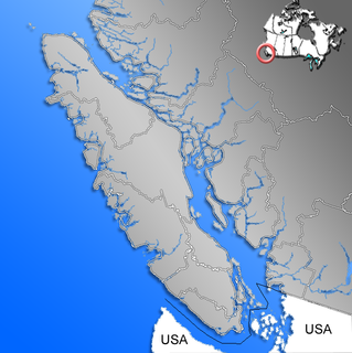
Lantzville is a coastal community on the east side of Vancouver Island, British Columbia, Canada along the western shore of the Strait of Georgia and immediately north of the City of Nanaimo.

The Regional District of Nanaimo is a regional district located on the eastern coast of Vancouver Island, British Columbia, Canada. It is bordered to the south by the Cowichan Valley Regional District, to the west by the Alberni-Clayoquot Regional District, and to the northwest by the Comox Valley Regional District. Its administration offices are located in Nanaimo. During the 2011 census, its population was established at 146,567.

Robert Dunsmuir was a Scottish-Canadian coal mine developer, owner and operator, railway developer, industrialist and politician in British Columbia.
School District 68 Nanaimo-Ladysmith is a school district on central Vancouver Island in British Columbia. This includes the major centres of Nanaimo and Ladysmith. It is also covers the surrounding communities and the adjacent northern Gulf Islands.

Harewood is the name of a lake and a plain of the Canadian province of British Columbia. It is located in Nanaimo, on the east coast of Vancouver Island. Its geographical coordinates are 49°08′N123°57′W The name has been in use since at least 1913, when Harewood referred to a small mining village in the area, no longer existing, having been overtaken by Nanaimo. The mine was owned in part by the seventh son of Henry Lascelles, 3rd Earl of Harewood who served on the BC coast as captain of the gunboat HMS Forward and set up the Harewood Coal Mining Company to work deposits he acquired.

Alderwood is a neighbourhood in the city of Toronto, Ontario, Canada. It is in the western section of Toronto, formerly the city of Etobicoke. It is bounded by the Etobicoke Creek to the west, the Gardiner Expressway to the north, the CPR railway to the east and the CNR railway to the south.
Wellington is the name of a north Nanaimo, British Columbia neighbourhood, which was once the town of Wellington. The community was named for Arthur Wellesley, 1st Duke of Wellington.

West Kelowna, formerly known as Westbank and coloquially known as Westside, is a city in British Columbia's Okanagan Valley. The city encompasses several distinct neighbourhoods, including Casa Loma, Gellatly, Glenrosa, Lakeview Heights, Shannon Lake, Smith Creek, Rose Valley, Westbank, and West Kelowna Estates. West Kelowna had an estimated population of 34,883 as of December 31, 2018.
Wellington Secondary School is a public high school located in Nanaimo, British Columbia. It is part of School District 68 Nanaimo-Ladysmith and is known for its music, film and athletics programs.
The Wellington station located in the Wellington area of Nanaimo, British Columbia, was a flag stop on Via Rail's Dayliner service, which ended in 2011. The station is on the Southern Railway of Vancouver Island mainline. The station was named after the town of Wellington which formed around and next to the Wellington Colliery which was named after Arthur Wellesley, 1st Duke of Wellington, a leading British military and political figure in the 19th century.
Victoria West, commonly called Vic West, is an historic neighbourhood of the city of Victoria, British Columbia, Canada, located just west of downtown across Victoria Harbour, bordering on the Township of Esquimalt.
Extension, originally Wellington Extension, is a community to the south of Nanaimo, British Columbia, Canada, on Vancouver Island.
Nanaimo, British Columbia had four Chinatown sites beginning in the 1800s.
References
- 1 2 "Wellington Public School 1875–1944, Mount Benson School 1950–1990 By Carol Jepson. Nanaimo Community Archives
- 1 2 "Dictionary of Canadian Biography Online — James Dunsmuir". Library and Archives Canada . Retrieved 2007-12-11.
- ↑ "New York Times" (PDF). New York Times. 1904-08-20. p. Front Page 2. Retrieved 2007-12-11.
- ↑ Victoria (CP) - Tuesday, July 28, 1942
- ↑ Hunter, Justice (June 28, 2008). "For whom the bell tolls". The Globe and Mail . Retrieved January 25, 2020.
- ↑ Honourable Christy Clark, Minister of Education and Deputy Premier. "Bill 34 -- 2002, School Amendment Act, 2002" . Retrieved 2009-01-28.
- ↑ School District 68 Staff (2008-01-30). "Public Consultation Process on Proposed School Closures". p. 15. Retrieved 2009-01-01.
- ↑ Marshall, Jenn (2009-01-02). "Nanaimo News Bulletin - Grants Boost Student Activity".Cite journal requires
|journal=(help) - 1 2 Walbran, Captain John T. (1971). British Columbia Place Names, Their Origin and History (Facsimile reprint of 1909 ed.). Vancouver/Toronto: Douglas & McIntyre. ISBN 0-88894-143-9. Archived from the original on 2016-03-03. Retrieved 2008-11-26.
- 1 2 David Mattison. "Camera Workers: The British Columbia, Alaska & Yukon Photographic Directory, 1858-1950 - B - Volume 1 (1858-1900)" . Retrieved 2007-12-11.
- ↑ "Wellington Secondary School History" . Retrieved 2009-05-03.