Derry Workhouse

Last updated

Coordinates: 54°59′42″N7°18′22″W / 54.995°N 7.306°W / 54.995; -7.306 Derry Workhouse was a workhouse in Derry, Northern Ireland. Located in the Waterside area of the city, the workhouse operated from 1840 to 1948.

Geographic coordinate system Coordinate system

A geographic coordinate system is a coordinate system that enables every location on Earth to be specified by a set of numbers, letters or symbols. The coordinates are often chosen such that one of the numbers represents a vertical position and two or three of the numbers represent a horizontal position; alternatively, a geographic position may be expressed in a combined three-dimensional Cartesian vector. A common choice of coordinates is latitude, longitude and elevation. To specify a location on a plane requires a map projection.

Workhouse place where those unable to support themselves were offered accommodation and employment

In England and Wales, a workhouse, colloquially known as a spike, was a place where those unable to support themselves were offered accommodation and employment. The earliest known use of the term workhouse is from 1631, in an account by the mayor of Abingdon reporting that "wee haue erected wthn our borough a workehouse to sett poore people to worke".

Derry city in Northern Ireland

Derry, officially Londonderry, is the second-largest city in Northern Ireland and the fourth-largest city on the island of Ireland. The name Derry is an anglicisation of the Old Irish name Daire meaning "oak grove". In 1613, the city was granted a Royal Charter by King James I and gained the "London" prefix to reflect the funding of its construction by the London guilds. While the city is more usually known colloquially as Derry, Londonderry is also commonly used and remains the legal name.

History

As a result of the Irish Poor Law Act of 1838, a workhouse with a capacity for 800 people opened in the city on 10 November 1840 and was the first operational workhouse in Ulster. During the Irish Famine (1845-1849), the number of people who were poverty-stricken drastically increased and, like many other workhouses in Ireland at the time, the workhouse experienced severe overcrowding. With the introduction of the National Assistance Act 1948 and the welfare state, the workhouse closed in 1948. [1]

The Irish Poor Law Act of 1838 was an Act of Parliament which created the system of poor relief in Ireland. The legislation was largely influenced by the English Poor Law Act of 1834.

Ulster province in Ireland

Ulster is a province in the north of the island of Ireland. It is made up of nine counties, six of which are in Northern Ireland and three of which are in the Republic of Ireland. It is the second largest and second most populous of Ireland's four provinces, with Belfast being its biggest city. Unlike the other provinces, Ulster has a high percentage of Protestants, making up almost half of its population. English is the main language and Ulster English the main dialect. A minority also speak Irish, and there are Gaeltacht in southern Londonderry, the Gaeltacht Quarter of Belfast and in Donegal, where 25% of the total Gaeltacht population of Ireland is located. Lough Neagh, in the east, is the largest lake in the British Isles, while Lough Erne in the west is one of its largest lake networks. The main mountain ranges are the Mournes, Sperrins, Croaghgorms and Derryveagh Mountains.

National Assistance Act 1948 social care-related UK parliament act of 1948

The National Assistance Act 1948 is an Act of Parliament passed in the United Kingdom by the Labour government of Clement Attlee. It formally abolished the Poor Law system that had existed since the reign of Elizabeth I, and established a social safety net for those who did not pay National insurance contributions and were therefore left uncovered by the National Insurance Act 1946 and the National Insurance Act 1946. It also provided help to elderly Britons who required supplementary benefits to make a subsistence living, and obliged local authorities to provide suitable accommodation for those who through infirmity, age, or any other reason were in need of care and attention not otherwise available. The legislation also empowered local authorities to grant financial aid to organizations of volunteers concerned with the provision of recreational facilities or meals.

The buildings housed the Waterside hospital until 1991, then were redeveloped as private housing, with the main dormitory area used as a library and museum. [2] [3] During the redevelopment, numerous human remains were found. These remains, believed to be of people who died in the mid-nineteenth century, were later interred in the local Ballyoan cemetery. [1]

The museum opened in 1997. In 2014, the Derry City Council decided to close the museum citing health and safety issues, and decreasing visitor numbers. The council planned to turn the space into apartments. [4]

Related Research Articles

County Donegal County in the Republic of Ireland

County Donegal is a county of Ireland in the province of Ulster. It is named after the town of Donegal in the south of the county. Donegal County Council is the local council and Lifford the county town.

County Londonderry Place in Northern Ireland, United Kingdom

County Londonderry, also known as County Derry, is one of the six counties of Northern Ireland. Prior to the partition of Ireland, it was one of the counties of the Kingdom of Ireland from 1613 onward and then of the United Kingdom after the Acts of Union 1800. Adjoining the north-west shore of Lough Neagh, the county covers an area of 2,074 km² and today has a population of about 247,132.

City of Derry Airport airport in the United Kingdom

City of Derry Airport is a regional airport located 7 mi (11 km) northeast of Derry, Northern Ireland. It is located on the south bank of Lough Foyle, a short distance from the village of Eglinton and 8 mi (13 km) from the city centre.

Derry City Council administrative territorial entity of the United Kingdom

Derry City Council was the local government authority for the city of Derry in Northern Ireland. It merged with Strabane District Council in April 2015 under local government reorganisation to become Derry and Strabane District Council.

Apprentice Boys of Derry

The Apprentice Boys of Derry is a Protestant fraternal society with a worldwide membership of over 10,000, founded in 1814 and based in the city of Derry, Northern Ireland. There are clubs and branches in Ulster and elsewhere in Ireland, Scotland, England, Australia and Toronto, Canada. The society aims to commemorate the 1689 Siege of Derry when Catholic James II of England and Ireland and VII of Scotland laid siege to the walled city, which was at the time a Protestant stronghold. Apprentice Boys parades once regularly led to virulent opposition from the city's Irish nationalist majority, but recently a more conciliatory approach has taken place and now the parades are virtually trouble-free. The 2014 'Shutting of the Gates' parade was described as "the biggest in years" and was violence-free.

Derry/Londonderry name dispute Dispute as to the name of the city of Derry and the historic county of Londonderry around it

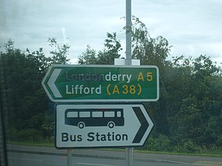
The names of the city and county of Derry or Londonderry in Northern Ireland are the subject of a naming dispute between Irish nationalists and unionists. Generally, although not always, nationalists favour using the name Derry, and unionists Londonderry. Legally, the city and county are called "Londonderry", while the local government district containing the city is called "Derry and Strabane". The naming debate became particularly politicised at the outset of the Troubles, with the mention of either name acting as a shibboleth used to associate the speaker with one of Northern Ireland's two main communities. The district of Derry and Strabane was created in 2015, subsuming a district created in 1973 with the name "Londonderry", which changed to "Derry" in 1984.

Brandywell Stadium football stadium

The Ryan McBride Brandywell Stadium is a municipal dual-use football and greyhound racing stadium located in Derry, Northern Ireland. It is the home ground of League of Ireland team Derry City F.C. and (temporarily) NIFL Premiership team Institute

Ballykelly, County Londonderry village in County Londonderry, United Kingdom

Ballykelly is a village and townland in County Londonderry, Northern Ireland. It lies 3 miles (4.8 km) west of Limavady on the main Derry to Limavady A2 road and is 15 miles (24 km) east of Derry. It is designated as a Large Village and in 2001 the population of Ballykelly was 1,827. It lies within Causeway Coast and Glens district.

Londonderry railway station British Railway Station

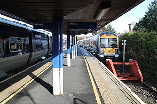
Londonderry Railway Station, known commonly as Waterside Railway Station, is a railway terminus in the city of Derry in Northern Ireland, on the east bank of the River Foyle. The station is also used by residents of the west of County Londonderry, much of west Tyrone and County Donegal. It is operated by Northern Ireland Railways. It serves the line to Belfast, whose other terminus is Great Victoria Street.

Ballyoan Cemetery is a cemetery in Derry, Northern Ireland.

Foyleside Shopping Centre

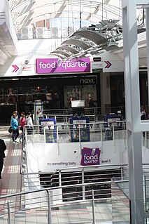
Foyleside Shopping Centre is a shopping centre in Derry, County Londonderry, Northern Ireland. Construction started in the early 1990s and the centre opened in 1995. The shopping centre's purpose was to offer a hub for shopping in the North West of Ireland.

Waterside, Derry

The Waterside generally refers to the part of Derry on the east bank of the River Foyle. Traditionally, the Waterside ends at the Caw roundabout near the Foyle Bridge. Areas such as Eglinton and Limavady are not part of the Waterside.

Belfast–Derry line railway line

The Belfast–Derry line runs from Belfast to Derry in Northern Ireland. The line is double-track on the short section it shares with the Belfast-Larne railway line, but is composed primarily of single track from Monkstown to Londonderry with passing points at Templepatrick, Antrim, Magherabeg, Ballymena, Killagan, Ballymoney, Coleraine and Bellarena.

City status in Ireland

In Ireland, the term city has somewhat differing meanings in Northern Ireland and the Republic of Ireland.

Derry and Strabane Local government district in Northern Ireland

Londonderry and Strabane is a local government district that was created on 1 April 2015 by merging the City of Derry District and Strabane District. It covers most of the northwest of Northern Ireland. The local authority is Derry City and Strabane District Council.

Foyle Valley Railway

The Foyle Valley Railway is a railway museum in Derry, Northern Ireland.

Gregory Campbell (politician) British politician

Gregory Lloyd Campbell is a Northern Ireland unionist politician, and the Democratic Unionist Party (DUP) Member of Parliament for East Londonderry. He has referred to himself as a loyalist.

1920 Londonderry Borough Council election

An election to Londonderry Borough Council took place on Thursday 15 January 1920 as part of that year's Irish local elections.

The Derry Brigade also known as the South Derry Brigade of the Provisional Irish Republican Army (IRA) operated in Derry, County Londonderry, Northern Ireland, during the Troubles. The Derry Brigade along with the Belfast Brigade, East Tyrone Brigade and the South Armagh Brigade were the four most active IRA Brigade areas during the conflict between 1969 and 1998.

References

  1. 1 2 Durnin, Patsy (11 May 2014). "Derry Workhouse: 'Thirteen Steps' to another world". Derry Journal. Retrieved 6 October 2016.
  2. "Workhouse Museum to close in April". Derry Journal. 21 March 2014. Retrieved 6 October 2016.
  3. Higginbotham, Peter (2003). "The Workhouse in Londonderry, Co. Londonderry". workhouses.org.uk. Retrieved 6 October 2016.
  4. Kevin Mullan (21 May 2016). "Flats planned for the haunted old Waterside Workhouse". Londonderrysentinel.co.uk. Retrieved 5 March 2017.