
Modoc County is a county in the far northeast corner of the U.S. state of California. Its population is 8,700 as of the 2020 census, down from 9,686 from the 2010 census. This makes it California's third-least populous county. The county seat and only incorporated city is Alturas. Previous county seats include Lake City and Centerville. The county borders Nevada and Oregon.

Fort Kearny was a historic outpost of the United States Army founded in 1848 in the western U.S. during the middle and late 19th century. The fort was named after Col. and later General Stephen Watts Kearny. The outpost was located along the Oregon Trail near Kearney, Nebraska. The town of Kearney took its name from the fort. The "e" was added to Kearny by postmen who consistently misspelled the town name. A portion of the original site is preserved as Fort Kearny State Historical Park by the Nebraska Game and Parks Commission.
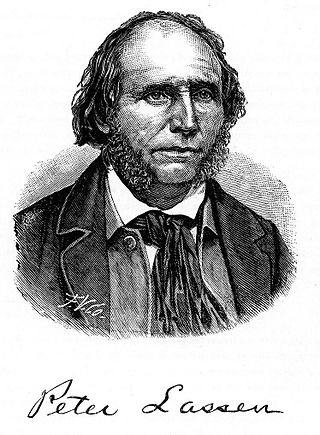
Peter Lassen, later known in Spanish as Don Pedro Lassen, was a Danish-born Californian ranchero and gold prospector. Born in Denmark, Lassen immigrated at age 30 to Massachusetts, before eventually moving to California. In California, Lassen became a Mexican citizen and received the vast Rancho Bosquejo from Governor Manuel Micheltorena. He is best known as the eponym of Lassen County, California, Lassen Peak, and Lassen Volcanic National Park.

Buildings, sites, districts, and objects in California listed on the National Register of Historic Places:
The Battle of Taliwa was fought in Ball Ground, Georgia, in 1755. The battle was part of a larger campaign of the Cherokee against the Muscogee Creek people, where a contingent of 500 Cherokee warriors led by war chief Oconostota defeated the Muscogee Creek people and pushed them south from their northern Georgia homelands, allowing the Cherokee to begin settling in the region.

The Nobles Emigrant Trail, also known as the Fort Kearney, South Pass and Honey Lake Wagon Road, is a trail in California that was used by emigrant parties from the east as a shortened route to northern California. It was pioneered in 1851 by William Nobles, who discovered an easy shortcut between the Applegate Trail in Nevada and the Lassen Trail in California. The trail was extensively used until the 1870s, when it was superseded by railroads.
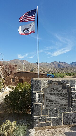
Vallecito, in San Diego County, California, is an oasis of cienegas and salt grass along Vallecito Creek and a former Kumeyaay settlement on the edge of the Colorado Desert in the Vallecito Valley. Its Spanish name is translated as "little valley". Vallecito was located at the apex of the gap in the Carrizo Badlands created by Carrizo Creek and its wash in its lower reach, to which Vallecito Creek is a tributary. The springs of Vallecito, like many in the vicinity, are a product of the faults that run along the base of the Peninsular Ranges to the west.

Palm Spring is a spring in Mesquite Oasis, a desert oasis amidst a mesquite thicket and a few palms, close to Carrizo Creek, within the Anza-Borrego Desert State Park in San Diego County, California.

William H. Nobles was a U.S military officer, Treasury Agent, businessman, politician and trailblazer

Fort Wicked was a ranch and stage station on the Overland Trail from 1864 to 1868 in present-day Merino, Colorado. A historical marker commemorating the ranch is located at US 6 and CR-2.5. The ranch itself was located near a ford of the South Platte River, near where US-6 now crosses over the river. Fort Wicked was one of the few places along the trail to Denver that withstood an attack by Lakota, Cheyenne, and Arapaho Native Americans in the Colorado War of 1864. It was named Fort Wicked for the "bitter defence" made by Holon Godfrey, his family, and his employees.

Kaawchama, alternatively referred to as Wa’aachnga, was a significant Tongva village in the San Bernardino Valley located in what is now west Redlands, California. The village became referred to by the Spanish as the Guachama Rancheria in 1810 after a supply station was constructed at the village for Mission San Gabriel, which then became part of Rancho San Bernardino following the secularization of the missions in 1833.

Battle Rock is a historical site of the Battle of the Crags at Castle Crags in Castella, California in Shasta County. The Battle Rock site is a California Historical Landmark No. 116 listed on March 29, 1933. The Battle of the Crags took place below Battle Rock in June 1855. The battle was fought on a ridge saddle between Castle lake and Battle Rock. Battle of the Crags was a battle between the Modoc people and the early settlers. Most of the settlers were California Gold Rush miners. The miners' operation destroyed the Modoc fishing areas by filling the Lower Soda Springs area with silt from mining. Squire Reuben Gibson and Mountain Joe Doblondy, the leaders of the miners and settlers, tried to entice Chief Weilputus, a leader of a local tribe who also were engaged in conflict with Modocs, to join them. The group battled the Modocs in June 1855 and was able to kill Modoc Chief Dorcas Della. With the loss of their leader the Modocs departed the area. Some of the miners and settlers were wounded in the battle, including Poet Joaquin Miller. Miller wrote later that he was shot at, and had an arrow go through his jaw and neck. Doc McCloud at Portuguese Flat inn worked on Miller's wounds and he rested there with the help of Mary Campbell McCloud. The battle was a precursor to the later and larger Modoc War between the Modoc people and the United States Army.

Fort Reading is a historical site in Anderson, California in Shasta County. Fort Reading site is a California Historical Landmark No. 379 listed on March 31, 1933. Founded on January 3, 1944, on west side of Cow Creek, Fort Reading was built to protect the settlers, California Gold Rush miners and travelers in the area. Fort Reading was founded by United States Army by Second Lieutenant E. N. Davis, Co. E, 2nd Infantry. Davis was sent to build the fort by Lieutenant Colonel George M. Wright. At the time the large fort was the first fort in Northern California. The fort was built in a 10 acres of land that had been cleared for good visibility. Fort Reading was named after Pierson Barton Reading. Most the larger base of troops were removed on April 1, 1856. The second draw down of troops was on June 13, 1867. The Fort Reading was completely abandoned on April 6, 1870. The Cow Creek would flood some years, flooding the fort sometimes. No trace of Fort Reading remains.
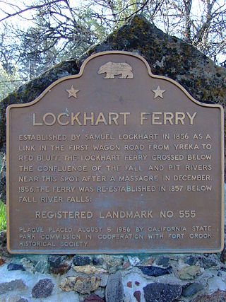
Lockhart Ferry foundation is a historical site in Fall River Mills, California in Shasta County. Lockhart Ferry site is a California Historical Landmark No. 555 listed on July 31, 1956. In 1856 Samuel Lockhart built a road and ferry, it was the first wagon trail road from the City of Yreka to the City of Red Bluff. To cross the Fall River Lockhart built a cable ferry across the river, just about the Pit River. Due to a native tribes attacks in the eara in December 1856, the ferry was moved down stream below Fall River Falls in 1857.

Old California Oregon Road is a historical site in Anderson, California, in Shasta County. Old California Oregon Road site is California Historical Landmark No. 58 listed on December 6, 1932. The Old California Oregon Road was the main road used by pioneer travelers between the Trinity River and the northern gold mines of California and Oregon. The main part of the Old California Oregon Road ran from Portland to Sacramento.
Pioneer Baby's Grave is a historical site in Redding, California in Shasta County. Pioneer Baby's Grave is a California Historical Landmark No. 377 listed on July 28, 1942. George and Helena Cohn Brownstein lived in Red Bluff. There infant son, 8-month-old, Charles Brownstein died on December 14, 1864. As there was Jewish cemetery in Red Bluff, George and Helena traveled 40 miles in two-days by covered wagon to a Jewish cemetery founded in 1857 by the Shasta Hebrew Congregation, Shasta Hebrew Benevolent Society. Charles was interred in Shasta Hebrew Congregation's Jewish cemetery, the first one found in the region. When California State Route 299 was built in 1923, the plans route the highway as to not disturb the grave. The Jewish cemetery was neglected for some years, till in 1976 when the Redding Jewish Community Center was founded. The site is now cared for by the Jewish Community Center.

Reading's Bar is a historical site in Redding, California in Shasta County. Reading's Bar is a California Historical Landmark No. 32 listed on August 1, 1932. Reading's Bar was named after Major Pierson Barton Reading, who discovered gold on the Clear Creek bar in May 1848, starting a California Gold Rush in the surrounding area. Later he found gold on a sandbar on the Trinity River that started the Trinity Alps Gold Rush. Reading's gold discovery was a major part of the California Gold Rush and news of the find created a rush of gold prospecting in Northern California, well north of the better-known gold fields of the Sierra Nevada foothills.

Piety Hill, California is a historical site on Cloverdale Road in Shasta County, near Igo, California. The city was founded in 1949 as part of the California Gold Rush. Like many Gold Rush camps that became a town, the town grew quickly from a few miners to a town of 1,500. Near Piety Hill was Chinatown of 600 that mined and farmed. The large scale Hardscrabble mine opened in 1853. Mining need lot of water and the Dry Creek Tunnel and Fluming Company both ran a water system, with a two-mile ditch, to the town and mines nearby, built with Chinese labor. In 1866 the Hardscrabble's hydraulic mining run off threatened the town. Many fed to nearby Igo. Hydraulic mining was outlawed in 1884 in the anti-debris act. The town ended in the 1920 when the last two Chinese residents died. The Dry Creek Tunnel and Fluming Company water right were transferred to the Happy Valley Land and Water Company that serves the Happy Valley area. There are no remains of this town. The Piety Hill Loop is 4.1-mile loop trail near near Igo. A historical was place near the form town by the Ono Grange #445, E Clampus Vitus, Trintarianus Chapter # 62 and the Department of the Interior and Bureau of Land Management.
Southern's Stage Station was built in 1859 by Simeon Fisher Southern. The Southern's Stage Station site is on 9010 Mears Ridge Road, south of Castella, California in Shasta County. The Southern's Stage Station is a California Historical Landmark No. 33 listed on August 1, 1932. Simeon Fisher Southern and his Sarah Southern operated the Stagecoach Station wife Southern's Stage Station and Southern Hotel were log cabin building built in 1859. Travelers on the stagecoach or riding through could stop for rest and food for the 50 years this station operated till 1909. The town was called Hazel Creek, California, but change to Sims, California in 1871 as Southern's Stage Station and store was the center of the town.
First Seat of Tehama County, First Tehama County Courthouse, is historical site in Tehama, California in Tehama County, California. The First Seat of Tehama County is a California Historical Landmark No. 183 listed on June 20, 1935. First Tehama County Courthouse was held in the a rented room inside the Union Hotel, later called the Heider House. Also meeting in the Union Hotel was the Tehama County's Board of Supervisors and other county officials. The Tehama County seat was in the Union Hotel from May 1856 to March 1857. In March 1857 the Tehama County seat moved to Red Bluff. The Heider House-Union Hotel was lost in a fire in 1908. The Heider House-Union Hotel was built on land what was part of the Robert Hasty Thomes (1817-1878) 22,212-acre Mexican land grant, Rancho Saucos.


