Devil's Lake (Wisconsin)

Last updated
Devil's Lake
Tawacunchukdah
Devils Lake.jpg
USA Wisconsin relief location map.svg
Red pog.svg
Devil's Lake
Usa edcp relief location map.png
Red pog.svg
Devil's Lake
Location Sauk County, Wisconsin, U.S.
Coordinates 43°25′05″N89°43′55″W / 43.41806°N 89.73194°W / 43.41806; -89.73194
Type Endorheic lake
Basin  countriesUnited States
Surface area374 acres (151 ha) [1]
Average depth30 ft (9.1 m) [1]
Max. depth47 ft (14 m) [1]

Devil's Lake is a lake in the South Range of the Baraboo Range, about two miles south of Baraboo, Wisconsin, in Sauk County, Wisconsin, United States. It has no surface outlets, so by some definitions, it is endorheic; however, it possibly drains by underground channels into the Baraboo River, which would make the lake cryptorheic. [2] The lake is one of the primary attractions of Devil's Lake State Park. It is also a popular recreation destination for watercraft, fishing, hiking, and climbing.

Contents

Name

Devil's Lake was so named because it is situated in a deep chasm that was thought to have no visible inlet or outlet. [3] However, the Koshawago Spring, originating from the Koshawago Creek, provides an inlet to the lake on the southwest side. [4] The term Devil's Lake is a misinterpretation of the Ho-Chunk name Te Wakącąk or Te Wakącągara. [5] Day-wa-kahn-chunk-gera, which better translates to "Sacred Lake" or "Spirit Lake." [6] [7] Spirit Lake is highly significant in Ho-Chunk oral history, and voices of spirits were often claimed to be heard during the celebrations.

History

The terminal moraine stretching across the former river gorge in Devil's Lake State Park Devils Lake Terminal Moraine.JPG
The terminal moraine stretching across the former river gorge in Devil's Lake State Park
View of the Northern shore of Devil's Lake Devils Lake State Park.jpg
View of the Northern shore of Devil's Lake

The original inhabitants of the area around the lake date back much further than when the European settlers first discovered the land. There is proof that humans occupied the land between 12,000 to 16,000 years ago, but Ho-Chunk speak of people living there more than 300,000 years ago. [8] The area may have been inhabited originally between 12,000 to 16,000 years ago due to the fact that this was the time the last of the glaciers had receded from the area. Many Native tribes throughout Wisconsin inhabited the lands. They called the lake various different names, such as Tewakakak or Minnewaukan, which translate to spirit lake in various Native American Languages. [8]

Devil's Lake was originally a gorge of the Wisconsin River prior to the last ice age. At what is now the southern end of the lake, the river turned from a southerly direction to an easterly direction. During the ice age, a lobe of the glacier passed to the east of the Baraboo Hills and came up the river valley. It deposited materials and then melted, leaving a terminal moraine blocking the river, forming an earthen dam. [9] Another moraine was deposited at the north end of the lake. The river eventually found a new course to the east of the Baraboo Hills, where the glacier had been, leaving a portion of the river gorge between the moraines filled with water. This body of water is Devil's Lake.

Geology

The Devil's Lake State Park is made up of bluffs that are believed to be one of the most ancient surface rock area in North America. Formed about 1.6 billion years ago, the land consists of Northern and Southern mountain ranges that are made up of quartzite rock. Quartzite was formed after ancient rivers deposited sediment from when this land was under water. Over time, that sediment accumulated into sandstone and underwent immense heat and pressure to form the non-porous metamorphic rock that now encompasses the Baraboo valley. The valley itself consists of softer rock as continental plate activity caused the quartzite rock to form into what's known now as the North and South range. [10]

Ecology

Wildlife

Devil's Lake is home to a diverse selection of wildlife. Naturally occurring fish include bass and panfish, while walleye, northern pike, and trout are stocked by the Wisconsin DNR. [11] Depending on the season, many types of birds can also be seen on the banks of Devil's Lake. Some of the more commonly seen birds include loons, herons, geese, and ducks. [12] The northern water snake can also be spotted swimming around Devil's Lake. Although the snake is not venomous, it can be aggressive if it feels endangered. [13]

Water quality

Swimmer's itch (cercarial dermatitis) is a common problem at Devil's Lake, most apparent during the summer months. [14] It is caused by a flatworm parasite hosted by snails. Seventeen species of snails are present in the lake, with three most commonly found snails-- Physa skinneri , Gyraulus parvus , and Fossaria obrussa--hosting the parasite. [15]

There have been reports of blue-green algae (cyanobacteria) blooming in Devil's Lake. The park advises visitors to stay alert for algae blooms, which can appear discolored, streaky, or with floating scum or globs on the surface. [16]

Water temperature

The water temperatures of Devil's Lake varies significantly throughout a calendar year. The highest water temperatures are reported between July and August between 75 and 80 degrees Fahrenheit. The lowest water temperatures for the year are in January, with an average temperature of 35 degrees Fahrenheit. [17] The lake freezes over in the winter, but ice thickness is unmeasured. [18]

Devils Lake activities

Boating, fishing, and swimming

The lake offers two beaches where guests can swim and relax: the North Shore and South Shore. Each beach provides picnic areas with grills and picnic tables, communal shelters containing bathrooms and concessions, and playgrounds. [19] There are also boat rentals, where visitors can rent pedal boats, paddle boards, and kayaks. During the summer months, kayaking tours of the lake are offered. [20]

Recreational fishing is apparent on the lakeshore and on boat. [21] Two boat launches are offered on the southwest and northeast sides of Devil's Lake. [22] However, to protect water quality, only electric-powered motors are allowed. [23] [21] The clear waters and unique rock formations also attract scuba-divers to the area. [24]

Hiking

Devils Lake State Park offers 29 miles of hiking trails that vary based on difficulty level, length, and terrain. Among the 17 established trails, the most popular is the tumbled rocks trail. It sits at the edge of the lake on the west end, stretching a mile long. The trail is paved, allowing it to be accessible for people with disabilities or visitors that wish to use a wheelchair, as well as ranked as "easy". [25] Many visitors report to using this trail in order to find a spot to fish from or a rock jump off of. The parks most popular diving rock, Rock 8, can be accessed via the Tumbled Rocks trail. [26] A second trail to highlight is the East Bluff Trail, with multiple overlooks and views, rock formations, and an abundance of wildlife. Rock formations pop up regularly throughout the trail, yet there are special appearances of the "Elephant Rock" and "Elephant Cave" along the way, two famous landmarks of the park. The trail continues for 1.7 miles, gaining over 500 feet of elevation and is expected to take hikers anywhere between 1.5 to 3 hours to complete.

Snow covered stone steps on the way up Devil's Head Gfp-wisconsin-devils-lake-state-park-snowy-stone-steps.jpg
Snow covered stone steps on the way up Devil's Head

Winter activities

Although the trails are not maintained during the winter, they remain open, supporting numerous activities.

Cross country skiing is popular at Devils Lake State Park. There is one loop trail used for skiing that continues along Steinke Basin Loop. [27] The trail is not tracked and conditions are not guaranteed to be great, yet visitors report that the overall experience is worth it.

The "multi use" Steinke Basin Loop trail is also quite frequently used for snowshoeing. [27] Devils Lake State Park allows visitors to roam free without restriction.

Related Research Articles

<span class="mw-page-title-main">Quartzite</span> Hard, non-foliated metamorphic rock

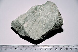
Quartzite is a hard, non-foliated metamorphic rock which was originally pure quartz sandstone. Sandstone is converted into quartzite through heating and pressure usually related to tectonic compression within orogenic belts. Pure quartzite is usually white to grey, though quartzites often occur in various shades of pink and red due to varying amounts of hematite. Other colors, such as yellow, green, blue and orange, are due to other minerals.

<span class="mw-page-title-main">Driftless Area</span> Geological region in the Midwestern US

The Driftless Area, also known as Bluff Country and the Paleozoic Plateau, is a topographical and cultural region in the Midwestern United States that comprises southwestern Wisconsin, southeastern Minnesota, northeastern Iowa, and the extreme northwestern corner of Illinois. The Driftless Area is a USDA Level III Ecoregion: Ecoregion 52. The Driftless Area takes up a large portion of the Upper Midwest forest–savanna transition. The Blufflands refers to the eastern section of the Driftless area in Minnesota, due to the steep bluffs and cliffs around the river valleys. The western half is known as the Rochester Plateau, which is flatter than the Blufflands. The Coulee Region refers to the southwestern part of the Driftless Area in Wisconsin. It is named for its numerous ravines.

<span class="mw-page-title-main">Devil's Lake State Park (Wisconsin)</span> State Park in Sauk County, Wisconsin

Devil's Lake State Park is a state park located in the Baraboo Range in eastern Sauk County, just south of Baraboo, Wisconsin. It is around thirty-five miles northwest of Madison, and is on the western edge of the last ice-sheet deposited during the Wisconsin glaciation. The state park encompasses 9,217 acres (3,730 ha), making it the largest in Wisconsin. The state park is known for its 500-foot-high (150 m) quartzite bluffs along the 360-acre (150 ha) Devil's Lake, which was created by a glacier depositing terminal moraines that plugged the north and south ends of the gap in the bluffs during the last ice age approximately 12,000 years ago. The sand at the bottom of Devil's Lake is thought to be deposited by glaciers.

<span class="mw-page-title-main">Interstate Park</span> United States historic place

Interstate Park comprises two adjacent state parks on the Minnesota–Wisconsin border, both named Interstate State Park. They straddle the Dalles of the St. Croix River, a deep basalt gorge with glacial potholes and other rock formations. The Wisconsin park is 1,330 acres (538 ha) and the Minnesota park is 298 acres (121 ha). The towns of Taylors Falls, Minnesota and St. Croix Falls, Wisconsin are adjacent to the park. Interstate Park is within the Saint Croix National Scenic Riverway and the Ice Age National Scientific Reserve. The western terminus of the Ice Age National Scenic Trail is on the Wisconsin side. On the Minnesota side, two areas contain National Park Service rustic style buildings and structures that are listed on the National Register of Historic Places.

<span class="mw-page-title-main">Kettle Moraine State Forest</span> State forest in Wisconsin, United States

The Kettle Moraine State Forest is a state forest in southeastern Wisconsin. The chief feature of the reserve is the Kettle Moraine, a highly glaciated area. The area contains very hilly terrain and glacial landforms, such as kettles, kames and eskers. The 56,000-acre (23,000 ha) forest is divided into two large and three small units, which are spread across a hundred miles.

<span class="mw-page-title-main">Horicon Marsh</span> National State Wildlife Area, Dodge and Fond du Lac counties, Wisconsin

Horicon Marsh is a marsh located in northern Dodge and southern Fond du Lac counties of Wisconsin. It is the site of both a national and a state wildlife refuge. The silted-up glacial lake is the largest freshwater cattail marsh in the United States.

<span class="mw-page-title-main">Rib Mountain State Park</span> State park in Wisconsin, United States

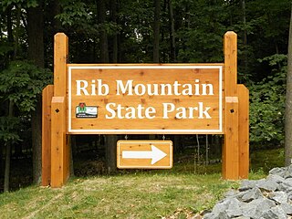
Rib Mountain State Park is a 1,528-acre (618 ha) Wisconsin state park near the city of Wausau. The park includes a ski resort, Granite Peak Ski Area, concession stand, picnic areas, a reservable amphitheater, a former quarry, observation tower, and 15.1 miles of trails. The park is ten miles (16 km) north-northwest of Central Wisconsin Airport.

<span class="mw-page-title-main">Whitefish Dunes State Park</span> State park in Wisconsin, United States

Whitefish Dunes State Park is a 867-acre (351 ha) state park of Wisconsin on the eastern shore of the Door Peninsula. This day-use park preserves the most substantial sand dunes on the western shore of Lake Michigan. The remains of eight successive prehistoric Native American villages are on the National Register of Historic Places as Whitefish Dunes-Bay View Site. Cave Point County Park is an enclave inside the state park, allowing visitors free foot access to the state park by the shoreline trail connecting the parks.

<span class="mw-page-title-main">Badger Army Ammunition Plant</span>

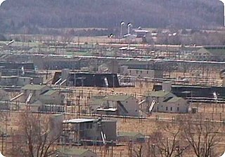
The Badger Army Ammunition Plant or Badger Ordnance Works (B.O.W.) is an excess, non-BRAC, United States Army facility located near Sauk City, Wisconsin. It manufactured nitrocellulose-based propellants during World War II, the Korean War, and the Vietnam War. It was a large munitions factory during World War II. As of 2013, the facility was in the end stages of demolition and remediation in preparation for property transfer.

<span class="mw-page-title-main">Lake Louise (Alberta)</span> Glacial lake in Banff National Park, Alberta, Canada

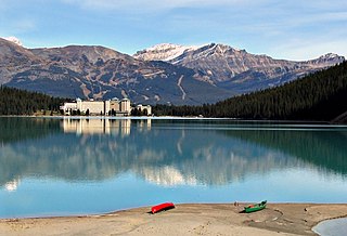
Lake Louise is a glacial lake within Banff National Park in Alberta, Canada. Situated 11 km (6.8 mi) east of the border with British Columbia, Lake Louise is located 5 km (3.1 mi) west of the hamlet of Lake Louise and the Trans-Canada Highway.

<span class="mw-page-title-main">Baraboo Range</span>

The Baraboo Range is a syncline located in Columbia and Sauk Counties, Wisconsin. It consists of highly eroded Precambrian metamorphic rock. It is about 25 miles (40 km) long and varies from 5 to 10 miles (16 km) in width. The Wisconsin River, previously traveling in a north to south direction, turns to the east just north of the range before making its turn to the west towards the Upper Mississippi River. The eastern end of the range was glaciated during the Wisconsinian glaciation, while the western half was not, and consequently, marks the eastern boundary of Wisconsin's Driftless Area.

<span class="mw-page-title-main">Geography of Wisconsin</span> Physical features of the state in the Midwestern United States

Wisconsin, a state in the Midwestern United States, has a vast and diverse geography famous for its landforms created by glaciers during the Wisconsin glaciation 17,000 years ago. The state can be generally divided into five geographic regions—Lake Superior Lowland, Northern Highland, Central Plain, Eastern Ridges & Lowlands, and Western Upland. The southwestern part of the state, which was not covered by glaciers during the most recent ice age, is known as the Driftless Area. The Wisconsin glaciation formed the Wisconsin Dells, Devil's Lake, and the Baraboo Range. A number of areas are protected in the state, including Devil's Lake State Park, the Apostle Islands National Lakeshore, and the Chequamegon–Nicolet National Forest.

<span class="mw-page-title-main">Kohler-Andrae State Park</span> State parks in Sheboygan County, Wisconsin

Kohler-Andrae State Park comprises two adjacent Wisconsin state parks located in the Town of Wilson, a few miles south of the city of Sheboygan. They are managed as one unit. Terry Andrae State Park, established in 1927, and John Michael Kohler State Park, established in 1966, total 988 acres (4.00 km2). The parks contain over two miles (3 km) of beaches and sand dunes along the shore of Lake Michigan, with woods and wetlands away from the water. The Black River flows through the parks.

<span class="mw-page-title-main">Pewit's Nest State Natural Area</span> State Natural Area in Wisconsin

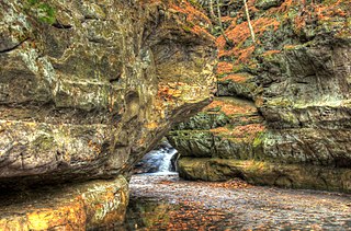
Pewit's Nest State Natural Area is a nature reserve in Wisconsin, USA, that includes a deep gorge formed during the retreat of the last glacier. Pewit's Nest is outside Baraboo in Sauk County. At one time a waterwheel and mill were located on the site and an individual lived in the solid sandstone. The name of the site was a result of early settlers calling it "Peewit's Nest" after the abode, ten feet above a deep pool of water, resembling the nest of a phoebe. The water-wheel once turned lathes for repairing or manufacturing equipment, but no evidence of it remains. Pewit's Nest is owned by the Wisconsin Department of Natural Resources and was designated a State Natural Area in 1985.

<span class="mw-page-title-main">Castle Rock Lake</span> Lake in Adams and Juneau counties, Wisconsin, United States

Castle Rock Lake is an artificial lake on the Wisconsin River. It is located in central Wisconsin in Adams County and Juneau County. The lake has an inflow from Petenwell Lake, Yellow River, Big Roche a Cri., and Klien Creek. It has a surface area of 16,640 acres (67.3 km2) and its depth varies from 8–20 ft (2.4–6.1 m) in most places, with area in the old river beds reaching as deep as 35 ft (11 m).

<span class="mw-page-title-main">Turtle-Flambeau Flowage</span> Lake of the United States of America

The Turtle-Flambeau Flowage is a 12,942 acres (52.37 km2) lake in Iron County, Wisconsin. It has a maximum depth of 15 meters and is the seventh largest lake in the state of Wisconsin by surface area. The flowage is home to unique wetland patterns and plant species as well as several species of sport and game fish, including Musky, Panfish, Largemouth Bass, Smallmouth Bass, Northern Pike, Walleye and Sturgeon. The lake's water clarity is low, but can vary in different locations in the lake. Fishing, camping, boating, and hunting are popular activities on the flowage, and Ojibwe people traditionally harvest fish and game on the lake. Environmental concerns on the flowage include mercury contamination, algal blooms, and several types of invasive species.

<span class="mw-page-title-main">Parfrey's Glen State Natural Area</span> State Natural Area in Wisconsin

Parfrey's Glen, located within Devil's Lake State Park, is a Wisconsin Department of Natural Resources-designated State Natural Area. The glen is a deep gorge cut through the sandstone of the south flank of the Baraboo Hills. It was the first State Natural Area to be designated in Wisconsin. The valley was named for Robert Parfrey.

<span class="mw-page-title-main">Baraboo Quartzite</span> Precambrian geological formation in Wisconsin

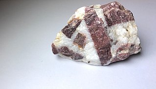
Baraboo Quartzite is a Precambrian geological formation of quartzite, found in the region of Baraboo, Wisconsin. While pure quartzite is usually white or gray, Baraboo Quartzite is typically dark purple to maroon in color, due to the presence of iron (hematite) and other impurities. Baraboo Quartzite may display strata created by progressive deposition of layers of sand in the original sandstone from which the quartzite was formed. Specimens of Baraboo quartzite may also display ripple marks that appear visually similar to the patterns one might see in the sand at a beach. Ripples indicate that the sandstone from which the quartzite was metamorphosed was originally water-laid sediment.

<span class="mw-page-title-main">Kettle Moraine State Forest - Southern Unit at Whitewater Lake</span>

The Southern Unit of the Kettle Moraine State Forest includes more than 22,000 acres of land throughout southern Wisconsin and spans several state parks and natural areas. The area also features varied environments from restored prairie, forests, and lakes, along with providing a multitude of recreational opportunities such as hiking, birdwatching, fishing, camping, and hunting. The Kettle Moraine Scenic Drive also extends within this region as well as through a larger portion of the state.

<span class="mw-page-title-main">Ableman's Gorge State Natural Area</span> Description of the Ableman Gorge

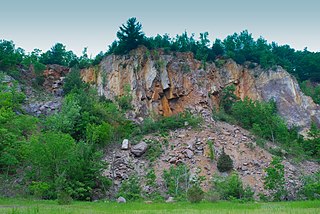
Ableman's Gorge is a 127 acres (51 ha) Wisconsin State Natural Area located near Rock Springs, Wisconsin. This 200 to 400-foot wide and 200-foot high gorge is cut by about 1 mile (1.6 km) of the Baraboo River in an "L" shape. The Natural Area is named after Stephen Van Rensselaer Ableman, who settled Rock Springs in 1851 and named the community after the gorge area.

References

  1. Arthur C. Trowbridge, "The History of Devils Lake, Wisconsin", The Journal of Geology25:4:344-372 (May-June 1917) JSTOR   30067000
  2. Gannett, Henry (1905). The Origin of Certain Place Names in the United States. Govt. Print. Off. pp.  105.
  3. "Devil's Lake". Devils Lake Climbing Guides. Retrieved 2024-04-04.
  4. "Devil's Lake -- How it Got its Name". hotcakencyclopedia.com. Retrieved 2022-05-02.
  5. Pillsbury, Diane (June 2011). "Devil's Lake State Park centennial". Wisconsin Natural Resources. Retrieved 8 January 2016.
  6. House, Charles (Mar 4, 1957). "By The Way". The Milwaukee Sentinel. pp. B1. Retrieved 18 August 2015.
  7. 1 2 "A Brief Human History of Devil's Lake State Park, Baraboo, WI". Devils Lake Climbing Guides. Retrieved 2022-05-02.
  8. A Geologic Tour of the Baraboo Ranges and Devil's Lake Gorge Archived 2007-06-30 at the Wayback Machine
  9. "Geology | Devil's Lake State Park | Wisconsin DNR". dnr.wisconsin.gov. Retrieved 2022-04-29.
  10. "Seasonal Fishing Guide to Devil's Lake State Park, Baraboo, WI". Devils Lake Climbing Guides. Retrieved 2024-04-11.
  11. "Bird Checklist Devil's Lake State Park" (PDF). Wisconsin DNR.
  12. "Rattlesnakes at Devil's Lake State Park". Devil's Lake State Park Area Visitor's Guide - DevilsLakeWisconsin.com. Retrieved 2024-04-11.
  13. "What Is Swimmer's Itch?". Devil's Lake State Park Area Visitor's Guide - DevilsLakeWisconsin.com. Retrieved 2024-04-11.
  14. Scheele, Carrie E.H.; Lathrop, Richard C.; Marshall, David W.; Decker, Erin L.; Lewis, David B.; Snyder, Scott D. "Friends of Devil's Lake State Park: Devil's Lake Swimmers Itch Study". Wisconsin DNR. p. 2.
  15. Mayoleth, Derrick (2023-05-16). "Caution, Blue-Green Algae". Devil's Lake State Park Area Visitor's Guide - DevilsLakeWisconsin.com. Retrieved 2024-04-11.
  16. "Devils Lake's current water temperature is 40°F. Today's forecast is: Overcast throughout the day., with a high around 52°F and a low around 41°F. Winds are out of the WNW at 7 mph with gusts of 23 mph". LakeMonster.com. Retrieved 2022-05-02.
  17. "Winter Recreation | Devil's Lake State Park | Wisconsin DNR". dnr.wisconsin.gov. Retrieved 2022-05-02.
  18. "Swimming at Devil's Lake State Park". Devil's Lake State Park Area Visitor's Guide - DevilsLakeWisconsin.com. Retrieved 2024-04-02.
  19. "Boating, Canoeing, Kayaking & SUPs". Devil's Lake State Park Area Visitor's Guide - DevilsLakeWisconsin.com. Retrieved 2024-04-02.
  20. 1 2 "Fishing | Devil's Lake State Park | Wisconsin DNR". dnr.wisconsin.gov. Retrieved 2024-04-02.
  21. "Devil's Lake". Devils Lake Climbing Guides. Retrieved 2024-04-02.
  22. Gay, Dannelle (2021-03-28). "A Complete Guide To Devil's Lake State Park". Crazy Camping Girl. Retrieved 2024-04-04.
  23. "Scuba Diving". Devil's Lake State Park Area Visitor's Guide - DevilsLakeWisconsin.com. Retrieved 2024-04-02.
  24. "Tumbled Rocks Trail". Devil's Lake State Park Area Visitor's Guide - DevilsLakeWisconsin.com. Retrieved 2022-04-27.
  25. "Rock 8". Devil's Lake State Park Area Visitor's Guide - DevilsLakeWisconsin.com. Retrieved 2022-04-27.
  26. 1 2 "Winter at Devil's Lake State Park: 5 BEST Snowy Actives". 2023-10-08. Retrieved 2024-03-14.

See also