Mulund is a suburb in the north-east of Mumbai, Maharashtra, India. It comes under zone railway station on the Central Railway line of the Mumbai Suburban Railway. It was first railway station of Mumbai Suburban district on the central railway line. Next station is, Thane railway station comes under Thane district. It is nestled alongside the foothills of the Sanjay Gandhi National Park with easy access to the Eastern Express Highway and Navi Mumbai through the Mulund-Airoli Bridge. Mulund marks the end of Mumbai city.
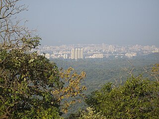
Borivali is a suburb which is located in the north-western end of Mumbai, India. It has a large Gujarati population. Traditionally the tribals and East Indians lived in Borivali.
Koliwada refers to a colony of Koli rajputs in India. Several places named Koliwada are located across the Mumbai city in India:
Madh Island is a group of several quaint fishing villages and farmlands in northern Mumbai.

Thakur Village is a densely populated residential locality in Kandivali, Mumbai, India. It is located to the east of the Western Express Highway, which is part of the National Highway 8.
Marol is a locality in the suburb of Andheri (East) in Mumbai, India.
Amboli is in Andheri (West), Mumbai, Maharashtra. Earlier known as Ambolim, it is situated very close to Andheri railway station and Jogeshwari railway station. At its heart, it also has a playground known as Joe and Helen Ground.

Asalpha or Asalfa is a neighbourhood in Ghatkopar (West), a suburb of Mumbai.
Vazira Naka is a predominantly residential neighbourhood in the Borivali (West) suburb of Mumbai. It was developed by the Paranjpe Developers in the 1950s. Key landmarks are Ganesha temple & Don Bosco School.

Charkop is a locality in the suburb of Kandivali (West), North Mumbai, India. Charkop's original name is 'Char K op'( चार खोप ) meaning a place of 4 huts or a small village with four houses in Marathi. Koli people or the fishermen are considered to be the indigenous residents of Charkop. They are a very old community who had presence in mumbai even before the Britishers or Portuguese when naming this village at that time it only have 4 huts (झोपडी) but now this village is grown by population nearly 5000 people are living in the Charkop koliwada, also they have their own temples and own festivals and unique culture.
Thane Municipal Transport (T.M.T) is a civic transport public company based in Thane, Maharashtra. T.M.T comes under Thane Municipal Corporation. It operates service in Thane city and into neighboring cities like Mumbai, Navi Mumbai, Bhiwandi, Mira-Bhayandar and Vasai-Virar.

Goregaon is a railway station on the Western line and Harbour line of the Mumbai Suburban Railway network. It serves the suburb of Goregaon. As a general rule, Virar-bound fast trains skip Goregaon, while Borivali-bound fast trains halt here but as it's located in between Andheri and Borivali, it works as an important halt for termination and origination of Churchgate and Mumbai CSMT/ Panvel bound services with access to Dindoshi, Oshiwara and Film City, as well as other areas such as Malad and Jogeshwari.
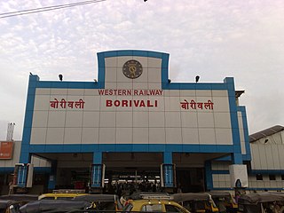
Borivali is a railway station on the Western line of the Mumbai Suburban Railway network and an outbound station. It serves the suburban of Borivali.

Dahisar is a railway station on the Western line of the Mumbai Suburban Railway network. Dahisar station is the last station within the Brihanmumbai Municipal Corporation limits. The area around the station has heavy traffic and is congested.

Mira Road is a passenger railway station located at Mira Road, a suburb in the Western Suburbs of Mumbai. It is situated between Borivali and Bhayandar stations on the Western line, of Mumbai Suburban Railway. The route of the station is located between the salt pan towards the western zone of the suburb leading towards Bhayandar.

Bhayandar is a railway station on the Western line of the Mumbai Suburban Railway network.
The Western Suburbs is the western precinct of the city of Mumbai, India. The Western Suburbs consist of Andheri, Bandra, Marol, Oshiwara Lokhandwala, Borivali, Dahisar, Goregaon, Versova, Jogeshwari, Juhu, Kandivali, Khar, Malad, Sakinaka, Santacruz and Vile Parle. Geographically, the Western Suburbs lie at the western part of Salsette Island, is a continuous urban sprawl spanning the areas from Bandra to Bhayander, which is separated by the Vasai Creek from Vasai-Virar city and Mithi River from Mumbai city district.
Kherwadi is a middle class, developing neighborhood, situated on the eastern side of Bandra railway station, Mumbai. Its name is derived from the first chief minister of Bombay State, B. G. Kher. It is surrounded by the CBD of BKC to the east, Mahim to the south, Khar to the north and S.V. Road to the west. It is well connected to all the parts of Mumbai, Navi Mumbai and Thane. Western Expressway passes through Kherwadi junction, a signal intersection situated in Kherwadi.
Mahavir Nagar is a locality situated at Kandivali West i.e. western part of Mumbai. This area is one of the well known location of the western suburbs and has a majority of Gujarati population.

