Dewar's Lane is an alley of medieval origin in the centre of Berwick-upon-Tweed. Over the centuries, heavy cart-wheels have cut deep grooves in its setts.
Once painted by the artist L. S. Lowry, it fell into an extreme state of dilapidation, overrun with pigeons and seagulls. Berwick Preservation Trust then stepped in and created a plan for the renovation of the lane's major building, Dewar's Lane Granary.
The Granary (which is situated on Dewar's Lane) has recently[when?] been strapped (as it has a tilt greater than the Leaning Tower Of Pisa) and transformed into a Youth Hostel, Bistro, Major Art Gallery and Public Meeting Rooms. The restored building is not only accessible from street level but also has access from both Berwick's Elizabethan Walls and Historic Quayside. This £5ml renovation will now remove what was considered to be the largest eyesore in the town.[1]
External links
Local article Information and images of places of interest around Berwick upon Tweed
Berwick-upon-Tweed, sometimes known as Berwick-on-Tweed or simply Berwick, is a town and civil parish in Northumberland, England, 2+1⁄2 mi (4 km) south of the Anglo-Scottish border, and the northernmost town in England. The 2011 United Kingdom census recorded Berwick's population as 12,043.
The River Tweed, or Tweed Water, Scots: Watter o Tweid, Welsh: Tuedd), is a river 97 miles (156 km) long that flows east across the Border region in Scotland and northern England. Tweed cloth derives its name from its association with the River Tweed. The Tweed is one of the great salmon rivers of Britain and the only river in England where an Environment Agency rod licence is not required for angling. The river generates a large income for the local borders region, attracting anglers from all around the world.
Berwickshire is a historic county, registration county and lieutenancy area in south-eastern Scotland, on the English border. The county takes its name from Berwick-upon-Tweed, its original county town, which was part of Scotland at the time of the county's formation in the twelfth century, but became part of England in 1482 after several centuries of swapping back and forth between the two kingdoms. After the loss of Berwick, Duns and Greenlaw both served as county town at different periods.
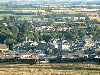
Duns is a town in the Scottish Borders, Scotland. It was the county town of the historic county of Berwickshire.
Berwick-upon-Tweed is a parliamentary constituency in Northumberland represented in the House of Commons of the UK Parliament since 2015 by Anne-Marie Trevelyan, a Conservative.
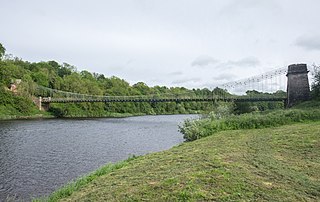
The Union Chain Bridge or Union Bridge is a suspension bridge that spans the River Tweed between Horncliffe, Northumberland, England and Fishwick, Berwickshire, Scotland. It is four miles (6.4 km) upstream of Berwick-upon-Tweed. When it opened in 1820 it was the longest wrought iron suspension bridge in the world with a span of 449 feet (137 m), and the first vehicular bridge of its type in the United Kingdom. Although work started on the Menai Suspension Bridge first, the Union Bridge was completed first. The suspension bridge, which is a Category A listed building in Scotland, is now the oldest to be still carrying road traffic.
Tweedmouth is part of the town of Berwick-upon-Tweed in Northumberland, England. It is located on the south bank of the River Tweed and is connected to Berwick town centre, on the north bank, by two road bridges and a railway bridge. Tweedmouth has historically always been part of England, in contrast to the walled town of Berwick which came under Scottish control for several periods in the Middle Ages. The local nickname for people from Tweedmouth is "Twempies". In 1951 the parish had a population of 6410.
Berwick Bridge, also known as the Old Bridge, spans the River Tweed in Berwick-upon-Tweed, Northumberland, England. The current structure is a Grade I listed stone bridge built between 1611 and 1624.
The Royal Tweed Bridge is a road bridge in Berwick-upon-Tweed, Northumberland, England crossing the River Tweed. It was intended to divert traffic from the 17th century Berwick Bridge, and until the 1980s it formed part of the A1 road, the main route from London to Edinburgh. However, the construction of the A1 River Tweed Bridge to the west of Berwick has since reduced the Royal Tweed Bridge's importance.
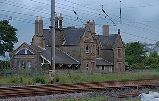
Berwick-upon-Tweed is a railway station on the East Coast Main Line, which runs between London King's Cross and Edinburgh Waverley. The station, situated 67 miles (108 km) north-west of Newcastle, serves the border town of Berwick-upon-Tweed in Northumberland, England. It is owned by Network Rail and managed by London North Eastern Railway.
Berwick Castle is a ruined castle in Berwick-upon-Tweed, Northumberland, England.
Chathill is a railway station on the East Coast Main Line, which runs between London King's Cross and Edinburgh Waverley. The station, situated 46 miles 1 chain north of Newcastle, serves the hamlet of Chathill, and surrounding coastal villages of Beadnell and Seahouses in Northumberland, England. It is owned by Network Rail and managed by Northern Trains.
The Church of the Holy Trinity, Berwick-on-Tweed is a Church of England parish church in the centre of Berwick-upon-Tweed, Northumberland. It is a rare example of a church built in the Commonwealth era.
Lowick is a village in Northumberland, north east England. Lowick lies on the B6353 road, about 10 miles (16 km) south of Berwick-upon-Tweed. The Anglican St John the Baptist's Parish Church dates from 1794, but a chapel was built in the 12th century by monks of Lindisfarne. The Grade II* listed Barmoor Castle, a castellated Tudor style country house is about a mile to the west of the village.
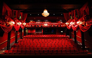
The Maltings is a cinema and live arts venue located in Berwick-upon-Tweed, Northumberland, UK.
Kilham is a hamlet and civil parish in the English county of Northumberland, located 8.0 miles (12.9 km) west of Wooler, 12.0 miles (19.3 km) east of Kelso, 17.0 miles (27.4 km) south west of Berwick-upon-Tweed and 38.9 miles (62.6 km) north west of Morpeth. It lies on the northern edge of the Northumberland National Park in Bowmont Valley Northumberland. The hamlet, which consists of a small group of agricultural dwellings, is overlooked by Kilham Hill and the northern limits of the Cheviot Hills. The parish had a population of 131 in 2001, and includes the hamlets of Howtel and Pawston, along with the former upland township of Coldsmouth and Thompson's Walls. falling to less than 100 at the 2011 Census. Details are now included in the parish of Branxton
Belford railway station is a disused station situated on the East Coast Main Line between the current Chathill and Berwick-upon-Tweed stations serving the village of Belford. It opened on 29 March 1847, closing on 29 January 1968. Today only the northbound station building remains.
Shaws Lane Relief Chapel in Berwick upon Tweed was founded in 1756 by a Presbyterian group seceding from the Low Meeting House in Hide Hill. The Congregation were of the Church of Scotland but preferred to choose their own Minister and so they pooled what money they had or could raise in order to fund its construction. The Relief Capel is situated between the High Street and Shaws Lane near the eastern extremity of Shaws Lane.
Berwick Town Hall is a municipal facility in Marygate, Berwick-upon-Tweed, England. The town hall, which was the headquarters of Berwick-upon-Tweed Borough Council, is a Grade I listed building.
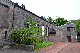
Our Lady and St Cuthbert Church is a Roman Catholic parish church in Berwick-upon-Tweed, Northumberland, England. It was built in 1829 in the Gothic Revival style, intentionally hidden away from the street. It is located on Ravensdowne to the south of Berwick Barracks in the centre of the town. It is a Grade II listed building.
This page is based on this Wikipedia article Text is available under the CC BY-SA 4.0 license; additional terms may apply. Images, videos and audio are available under their respective licenses.