Related Research Articles

The Betsy Ross Bridge is a continuous steel truss bridge spanning the Delaware River from Philadelphia, Pennsylvania to Pennsauken, New Jersey. It was built from 1969 to 1974, and opened in April 1976, during the American Bicentennial Year. It was originally planned to be named as the "Delair Bridge", after a paralleling vertical lift bridge owned by Pennsylvania Railroad, which is now used by Conrail Shared Assets Operations and New Jersey Transit's Atlantic City Line, but was instead later named for Betsy Ross, a Philadelphia seamstress and reputed creator of the first American flag in 1776. It was the first automotive bridge named for a woman in the United States, and the second U.S. bridge overall named for a woman after Iowa's Boone High Bridge was renamed the Kate Shelley High Bridge in 1912.

The Jhelum River is a major river in South Asia, flowing through India and Pakistan, and is the westernmost of the five major rivers of the Punjab region. It originates at Verinag and flows through the Indian-administered territory of Jammu and Kashmir, into Pakistan-administered Azad Kashmir, then the Pakistani province of Punjab. It is a tributary of the Chenab River and has a total length of about 725 kilometres (450 mi).

The Mangla Dam is a multipurpose dam situated on the Jhelum River, lying in the Mirpur District of Azad Kashmir and the Jhelum District in Punjab, Pakistan. It is the sixth-largest dam in the world. The village of Mangla, which sits at the mouth of the dam, serves as its namesake. In November 1961, the project's selected contractors were revealed; it was announced that Binnie & Partners, a British engineering firm, was going to serve as the lead designers, engineers, and inspectors for the construction of the dam. The project was undertaken by a consortium known as the Mangla Dam Contractors, which consisted of eight American construction firms sponsored by the Guy F. Atkinson Company based in South San Francisco, California.

Mangla is a town situated in District Mirpur within the region of Azad Kashmir. The village is located in the west of the foothills of Mangla's fort. It is surrounded on three sides by the semicurvature of river Jhelum flowing North to South. It is bordered with Jhelum district and with the right bank of Mangla between the State of Azad Kashmir and Punjab province of Pakistan.

The Tennessee–Tombigbee Waterway is a 234-mile (377 km) artificial U.S. waterway built in the 20th century from the Tennessee River to the junction of the Black Warrior-Tombigbee River system near Demopolis, Alabama. The Tennessee–Tombigbee Waterway links commercial navigation from the nation's midsection to the Gulf of Mexico. The major features of the waterway are 234 miles (377 km) of navigation channels, a 175-foot-deep (53 m) cut between the watersheds of the Tombigbee and Tennessee rivers, and ten locks and dams. The locks are 9 by 110 by 600 feet, the same dimension as those on the Mississippi above Lock and Dam 26 at Alton, Illinois. Under construction for 12 years by the U.S. Army Corps of Engineers, the Tennessee–Tombigbee Waterway was completed in December 1984 at a total cost of nearly $2 billion.

Roads in India are an important mode of transport in India. India has a network of over 6,617,100 km of roads. As of Dec 2024, India has the largest road network in the world. At of roads per square kilometre of land, the quantitative density of India's road network is equal to that of Hong Kong, and substantially higher than the United States, China, Brazil and Russia. Adjusted for its large population, India has approximately 5.13 kilometres (3.19 mi) of roads per 1,000 people, which is much lower than United States 20.5 kilometres (12.7 mi) but higher than that of China 3.6 kilometres (2.2 mi). India's road network carries over 71% of its freight and about 85% of passenger traffic.
New Jhang is a village in Pakistan situated on the Mangla Rd, 4 km from Dina in Jhelum District, Punjab. It is 10 km from the Mangla Dam.
Kakra is a village in Mirpur District of Azad Kashmir, Pakistan. situated at coordinates 33°7'33"N 73°52'47"E. The nearest village is Potha Bainsi. It is 26 km from the city of Jhelum.
Chechian is a village the Mirpur Tehsil of Mirpur District of Azad Kashmir, Pakistan.

The Stevenson Dam Bridge carries Connecticut Route 34 over the Housatonic River in the U.S. state of Connecticut, connecting the town of Monroe to the town of Oxford.
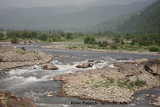
The Poonch River is a tributary of the Jhelum River that flows through Jammu and Kashmir in India, and Jammu and Kashmir in Pakistan.

The Neelum–Jhelum Hydropower Plant is part of a run-of-the-river hydroelectric power project in Azad Kashmir (AJK) designed to divert water from the Neelum River to a power station on the Jhelum River. The power station is located 42 km (26 mi) south of Muzaffarabad, and has an installed capacity of 969 MW. Construction on the project began in 2008 after a Chinese consortium was awarded the construction contract in July 2007. After many years of delays, the first generator was commissioned in April 2018 and the entire project was completed in August 2018 when the fourth and last unit was synchronized with the national grid on 13 August and attained its maximum generation capacity of 969 MW on 14 August 2018. It will generate 5,150 GWh per year at the levelised tariff of Rs 13.50 per unit for 30 years.
Gulpur Hydropower Plant (GHPP) is an operational run-of-the-river hydroelectric generation project located on Poonch River, a major tributary of Jhelum River near Gulpur in Kotli District of Azad Kashmir, Pakistan. The site is about 167 km from Federal Capital Islamabad and 285 kilometres (177 mi) from Punjab's Provincial Capital Lahore and is approachable directly from Islamabad and Lahore by a two-lane, all-weather, paved, partly mountainous road. The location of the project is about 28 km upstream of Mangla Dam Reservoir.
The New Bong Escape Hydropower Project is a privately owned 84 MW run-of-the-river project located on Jhelum River 7.5 km downstream of the 1,070 MW Mangla Dam, a major multi-purpose water storage project commissioned. It is about 120 km from Islamabad, the capital city of Pakistan. The project commenced commercial operations on 23 March, 2013 and has the distinction of being Pakistan and AJ&K’s first hydropower IPP. By developing a bankable framework this trendsetting project has paved the way for rapid and full scale development of Pakistan and AJ&K’s hydropower potential.
The Karot Hydropower Project is an asphalt-core rockfill gravity dam in Pakistan, with an installed capacity of 720 MW. The project is sponsored by Chinese state-owned company China Three Gorges Corporation (CTG).

As part of the China–Pakistan Economic Corridor, reconstruction and upgrade works are underway on the 887-kilometre-long (551 mi) National Highway 35 (N-35), which forms the Pakistani portion of the Karakoram Highway (KKH).

Rathoa Haryam Bridge, Mirpur, also known as the Islamgarh Bridge is a three kilometre long bridge currently under construction, located in the Mirpur District of Azad Jammu Kashmir in Pakistan. In 2011, the cost of the bridge was estimated to be around Rs. 6.48 billion.

Samote Union Council is located in Punjab, Pakistan. Previously part of Tehsil Kahuta, it was officially designated as a union council of Tehsil Kallar Syedan in Rawalpindi District on 1 July 2004.
Mangla Fort is a historical fort located in Mangla, Azad Kashmir. It is currently under the administration of the Pakistan Army and is not publicly accessible.
References
- ↑ "Water storage in Mangla Dam reaches historic high". The Express Tribune. 6 August 2013. Retrieved 1 February 2024.
- 1 2 "New bridge over Jhelum to open next month". Dawn. 2011-05-09. Retrieved 2024-10-03.
- ↑ "Wapda completes Rs 1.012 billion Dhan Gali Bridge project". Brecorder. 10 May 2011. Retrieved 21 January 2025.
33°21′38″N73°34′04″E / 33.36053°N 73.56767°E
| | This article about a bridge in Pakistan is a stub. You can help Wikipedia by expanding it. |