
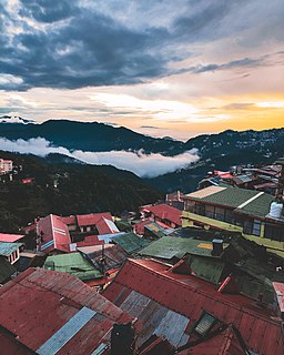
Shimla is the capital and the largest city of the Northern Indian state of Himachal Pradesh. In 1864, Shimla was declared as the summer capital of British India. After independence, the city became the capital of Punjab and was later made the capital city of Himachal Pradesh. It is the principal commercial, cultural and educational centre of the state. It was the capital city in exile of British Burma from 1942 to 1945.

Solan is a city in the Indian state of Himachal Pradesh and the district headquarters of Solan district. The 3rd largest Municipal Corporation of Himachal Pradesh after Shimla and Dharamshala, it is located 45.5 kilometres (28 mi) south of the state capital, Shimla, and at an average elevation of 1,550 metres (5,090 ft). The hill-town is named after the Hindu goddess Shoolini Devi ~ who is a manifestation of Goddess Durga in Her warrior aspect. Shoolini literally means 'the goddess wielding the spear'.. Every year in June, a fair venerating the Goddess is held, featuring a 3-day mela at the central Thodo ground. Solan was the capital of the erstwhile princely state, Baghat.

Kalka is a town in the Panchkula district of Haryana, India. It is near Panchkula city. The name of the town is derived from the Hindu goddess Kali. It is situated in the foothills of the Himalayas and is a gateway to the neighbouring state of Himachal Pradesh. It is on the National Highway 22 between Chandigarh and Shimla, and it is the terminus of the Kalka-Shimla Railway. To the south of Kalka is Pinjore, and the industrial village of Parwanoo is to the north on the NH 22. Industrial development has led to a continuous urban belt from Pinjore to Parwanoo, but Kalka gained major economic benefits due to only highway until 2010, shimla. It is the tehsil of 253 nearby sub villages. Nearby is Chandimandir Cantonment, where the Western Command of the Indian army is based. In 2013, the municipal committee of Kalka was dissolved and the administration was reassigned to Panchkula Municipal Corporation.

Manali is a town in the Indian state of Himachal Pradesh. It is situated in the northern end of the Kullu Valley, formed by the Beas River. The town is located in the Kullu district, approximately 270 kilometres (170 mi) north of the state capital of Shimla and 544 kilometres (338 mi) northeast of the national capital of Delhi. With a population of 8,096 people recorded in the 2011 Indian census Manali is the beginning of an ancient trade route through Lahaul and Ladakh, over the Karakoram Pass and onto Yarkand and Hotan in the Tarim Basin of China. Manali is a popular tourist destination in India and serves as the gateway to the Lahaul and Spiti district as well as the city of Leh in Ladakh.

Ambala is a city and a municipal corporation in Ambala district in the state of Haryana, India, located on the border with the Indian state of Punjab and in proximity to both states capital Chandigarh. Politically, Ambala has two sub-areas: Ambala Cantonment and Ambala City, eight kilometres apart, therefore it is also known as "Twin City". It has a large Indian Army and Indian Air Force presence within its cantonment area.It is located 200 km (124 mi) to the north of New Delhi, India's capital, and has been identified as a counter-magnet city for the National Capital Region to develop as an alternative center of growth to Delhi.
The Mountain railways of India are the narrow-gauge railway lines that were built in the mountains of India.

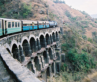
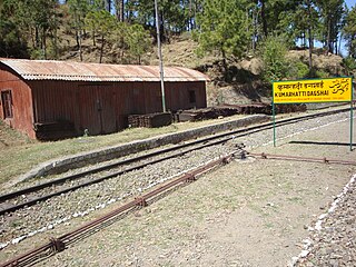
The Kalka–Shimla railway is a 2 ft 6 in narrow-gauge railway in North India which traverses a mostly mountainous route from Kalka to Shimla. It is known for dramatic views of the hills and surrounding villages. The railway was built under the direction of Herbert Septimus Harington between 1898 and 1903 to connect Shimla, the summer capital of India during the British Raj, with the rest of the Indian rail system.
Barog is a hill station in Solan district in the Indian state of Himachal Pradesh. The station lies on UNESCO World Heritage Site Kalka–Shimla Railway. Set in the mountains Barog is just 60 km from Chandigarh on the Kalka-Shimla highway.

Chail is a hill station in Himachal Pradesh, India. It is 44 kilometres (27 mi) from Shimla and 45 kilometres (28 mi) from Solan. It is known for its salubrious beauty and virgin forests. The Chail Palace is well known for its architecture: the palace was built as summer retreat by the Maharaja of Patiala during the British Raj, on the land allotted to him by the British for former's assistance in the Anglo-Nepalese War. The cricket ground and a polo ground which is there at an altitude of 2,444 m was owned by erstwhile royal family of Patiala. It is the world's highest cricket ground.
Dagshai also known as Daagh-e-Shahi is one of the oldest cantonment towns in the Solan district of Himachal Pradesh, India. It is situated on top of a 5,689-foot (1,734-m) high hillock that stands sphinx-like astride the Kalka-Shimla Highway at a point about 11 km from Solan. It was founded in 1847 by the East India Company by securing free of cost five villages from Maharaja of Patiala aka Bhupinder Singh of Patiala. The name of these villages were Dabbi, Badhtiala, Chunawad, Jawag and Dagshai.

Parwānoo or Parwanu is a municipal council in Solan district in the Indian state of Himachal Pradesh. It is an industrial town. It has himachal's biggest wholesale market. It borders Panchkula district of Haryana, and is after the towns of Pinjore and Kalka on the Chandigarh Simla Highway. In fact it is separated by a river bed from the town of Kalka.

Theog is a town and a municipal committee as well as a tehsil in Shimla district in the Indian state of Himachal Pradesh. It's just 26 km from state capital Shimla. First settlements were in 1902.

Chandi Mandir Cantonment is a military cantonment of the Indian Army located in Panchkula district at the foot of the Sivalik Hills adjoining Panchkula city in Haryana. It is the headquarters of the Western Command of the Indian Army.
Chail Sanctuary is located at Chail, a hill station which is home to sambar, goral and cheer pheasants at Blossom and Jhaja. Barking deer and kalijin are seen during dusk and dawn. The best time to visit is from March to October.
The development of tribal areas in Himachal Pradesh is one of the major steps taken by the state government for its economic development. The border districts of Kinnaur, Lahaul, Spiti and the Pangi and Bharmour tehsils of Chamba districts are the major tribal areas of the state. They are located near the borders of Tibet and Indian States of Jammu and Kashmir. Other backward areas include Shillai in Sirmaur district, and deep cut-off valleys in the Kullu and upper stretches of Kangra districts. Due to poor accessibility, life in these areas had grown in isolation.

Kasauli Brewery and Distillery, at Kasauli in Solan district of Himachal Pradesh state of India, was established in late 1820s during the British Raj by Edward Abraham Dyer - father of "The Butcher of Jallianwala Bagh massacre", Colonel Reginald Edward Harry Dyer. It started producing Asia's first beer brand, the "Lion Beer", and India's first single malt whisky, the ""Solan No. 1". Both of these brands are still in production. After the swap of brewery at Kasauli to Solan distillery and vice versa in 1835, presently Lion beer is produced at Solan and Solan No.1 whisky is produced at the Kasauli distillery using some of the original equipment including the copper pot still. The production of Lion beer was moved 25 km east to Solan Brewery at Solan, due to water scarcity, after civilian Kasauli hill station resort town came up around the brewery. Lion beer was originally an India Pale Ale (IPA), but the beer style was changed to lager in 1960s.
Junga is a tehsil in the Shimla district of Himachal Pradesh, India. Its original name is Jūnga.

Pinegrove School, established in 1991, in Solan, Himachal Pradesh, India, is a co-educational, purely residential, English medium public school affiliated to the Central Board of Secondary Education(CBSE), Delhi, up to the senior secondary stage.

The Himalayan Expressway is a 27.5 km stretch of highway in India that runs through the Shivaliks at the trijunction of Haryana, Punjab, and Himachal Pradesh. It connects Zirakpur in Punjab to Parwanoo in Himachal Pradesh. The stretch runs through 2 km in Zirakpur, Punjab, 21 km in Panchkula, Haryana, and 4.5 km in Parwanoo, Himachal Pradesh. It was constructed by Jaypee Group.
Tourism in Himachal Pradesh relates to tourism in the Indian state of Himachal Pradesh. This is popularly renowned for its Himalayan landscapes and popular hill-stations. Many outdoor activities such as rock climbing, mountain biking, paragliding, ice-skating, trekking, rafting, and heli-skiing are popular tourist attractions in Himachal Pradesh.

