
Farmington Township is a township in Clarion County, Pennsylvania, United States. The population was 1,785 at the 2020 census, a decrease from 1,934 at the 2010 census.

Waterford Township is a township in Erie County, Pennsylvania, United States. The population was 3,921 at the 2020 census, up from 3,920 at the 2010 census.

Freehold Township is a township in Warren County, Pennsylvania, United States. The population was 1,217 at the 2020 census, down from 1,510 at the 2010 census.

Sugar Grove Township is a township in Warren County, Pennsylvania, United States. The population was 1,622 at the 2020 census, down from 1,723 at the 2010 census.

Derry Township is a township in Westmoreland County, Pennsylvania. It surrounds the Borough of Derry, which is a separate municipality. As of the 2020 census, the township population was 13,631.
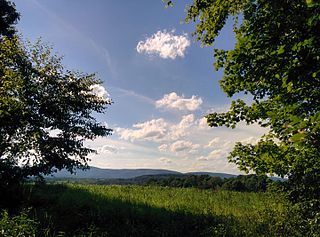
Fairfield Township is a township in Westmoreland County, Pennsylvania, United States. The population was 2,051 at the 2020 census.

North Huntingdon Township is a township in Westmoreland County, Pennsylvania, USA. The population was 31,847 at the 2020 census.
Gurd Township is an historical geographic township in central Ontario, Canada, in the Almaguin Highlands region of Parry Sound District. It was first surveyed in 1875 and was named after Robert Sinclair Gurd, a businessman and one-time mayor of Sarnia. In 1970, Gurd was annexed by the incorporated Nipissing.

The Stswecem'c Xgat'tem First Nation, formerly known as Canoe Creek Band/Dog Creek Indian Band, created as a result of merger of the Canoe Creek Band and Dog Creek Band is a First Nations government of the Secwepemc (Shuswap) Nation, located in the Fraser Canyon-Cariboo region of the Central Interior of the Canadian province of British Columbia. It was created when the government of the then-Colony of British Columbia established an Indian reserve system in the 1860s. It is a member government of the Northern Shuswap Tribal Council.
The Kluskus First Nation is the band government of the Lhoosk’uz, a Dakelh people whose main reserve located on the Chilcotin Plateau 130 km west of the city of Quesnel, British Columbia, Canada. The First Nation is a member of the Carrier-Chilcotin Tribal Council, which includes both Tsilhqot'in and Carrier (Dakelh) communities.

The French submarine Rubis was a Saphir-class minelaying submarine which first served in the French submarine pavilion, then the Free French Naval Forces (FNFL) during the Second World War and back with the French Navy. The boat was awarded numerous awards. Accordingly, as a result of Rubis's service with the FNFL, the boat was made a companion of the Ordre de la Libération by a decree issued by General Charles de Gaulle on 14 October 1941.

Santaliestra y San Quílez, in Aragonese: Santa Llestra y Sant Quílez, is a municipality located in the province of Huesca, Aragon, Spain. According to the 2004 census (INE), the municipality has a population of 102 inhabitants.
Matigara is a community development block that forms an administrative division in the Siliguri subdivision of the Darjeeling district in the Indian state of West Bengal.
Thikri is a town and a tehsil in Barwani District, Madhya Pradesh, India.

Fimbulheimen is a mountain range in Queen Maud Land, Antarctica. It stretches from Jutulstraumen by 1° west of Carsten Borchgrevink Ice at 18° east, about 200 km from the ice edge. Fimbulheimen is thus between Maudheim Plateau and Sør-Rondane.
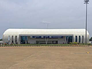
Pondicherry Airport is a regional airport located at Lawspet in Puducherry, a Union territory of India. It is situated 8.1 km from the international community of Auroville. The airport has scheduled flights and operations of the local flying training school. In 2007, the Government of Puducherry decided to expand the airport to accommodate larger aircraft and commissioned a new terminal building. The new terminal was inaugurated on 18 January 2013, with the arrival of a SpiceJet flight from Bengaluru. After a gap of three years, the airport was operationalised again under the UDAN scheme in August 2017, with a daily flight to Hyderabad.

Maillen is a village of Wallonia and district of the municipality of Assesse, located in the province of Namur, Belgium.
Galveston is an unincorporated community in Pittsylvania County, in the U.S. state of Virginia.

The Ailik or Aylik Lake is a lake in Xinjiang Uighur Autonomous Region, China. It is located in the northwestern part of the Dzungarian Basin, on the edge of the Gurbantünggüt Desert. Administratively, the lake is situated within the Urho District of Karamay City, some 20 km south-east of the district's main urban area.

Santa Eugenia is an administrative neighborhood (barrio) of Madrid belonging to the district of Villa de Vallecas. It has an area of 2.070637 km2 (0.799477 sq mi). As of 1 March 2020, it has a population of 24,782. The Hospital Universitario Infanta Leonor is located in the neighborhood.

