
The Main is the longest tributary of the Rhine. It rises as the White Main in the Fichtel Mountains of northeastern Bavaria and flows west through central Germany for 525 kilometres (326 mi) to meet the Rhine below Russelsheim, Hesse. The cities of Mainz and Wiesbaden are close to the confluence.

The River Don is a river in South Yorkshire and the East Riding of Yorkshire, England. It rises in the Pennines, west of Dunford Bridge, and flows for 70 miles (110 km) eastwards, through the Don Valley, via Penistone, Sheffield, Rotherham, Mexborough, Conisbrough, Doncaster and Stainforth. It originally joined the Trent, but was re-engineered by Cornelius Vermuyden as the Dutch River in the 1620s, and now joins the River Ouse at Goole. Don Valley is a UK parliamentary constituency near the Doncaster stretch of the river.

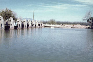
A weir or low head dam is a barrier across the width of a river that alters the flow characteristics of water and usually results in a change in the height of the river level. They are also used to control the flow of water for outlets of lakes, ponds, and reservoirs. There are many weir designs, but commonly water flows freely over the top of the weir crest before cascading down to a lower level.
Chasewater is a reservoir located in the parish of Burntwood and the district of Lichfield in Staffordshire, England. Originally known as Norton Pool and Cannock Chase Reservoir, it was created as a canal feeder reservoir in 1797. The reservoir was created to directly supply the Wyrley and Essington Canal and maintain levels in the 160-mile (260 km) Birmingham Canal Network. During a period of great industrial growth in the Black Country region the maintenance of water levels in canal infrastructure was essential and Chasewater was in great demand. As canals became less essential for transport of goods during the mid-20th century, the reservoir diversified and became a popular public amenity with activities such as water-skiing, sailing, wakeboarding and cycling. Chasewater is the third largest reservoir by volume in the county of Staffordshire and the largest canal feeder reservoir in the West Midlands.

A canal pound, reach, or level, is the stretch of level water impounded between two canal locks. Canal pounds can vary in length from the non-existent, where two or more immediately adjacent locks form a lock staircase, to many kilometres/miles.
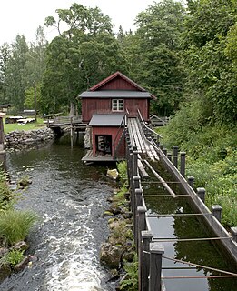
A flume is a human-made channel for water, in the form of an open declined gravity chute whose walls are raised above the surrounding terrain, in contrast to a trench or ditch. Flumes are not to be confused with aqueducts, which are built to transport water, rather than transporting materials using flowing water as a flume does. Flumes route water from a diversion dam or weir to a desired materiel collection location. Flumes are usually made up of wood, metal or concrete.

The Augsburg Eiskanal is an artificial whitewater river in Augsburg, Germany, constructed as the canoe slalom venue for the 1972 Summer Olympics in nearby Munich.

The Upper Nepean Scheme is a series of dams and weirs in the catchments of the Cataract, Cordeaux, Avon and Nepean rivers of New South Wales, Australia. The scheme includes four dams and two weirs, and a gravity-fed canal system that feeds into a large storage reservoir to provide water to the Macarthur and Illawarra regions, the Wollondilly Shire, and metropolitan Sydney. The four dams and associated infrastructure are individually listed on the New South Wales State Heritage Register.

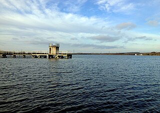
The Tidewater Lock is a dam in Washington, D.C. to the west of the mouth of Rock Creek at the Potomac River, on the east side of Georgetown. Built to connect the Chesapeake and Ohio Canal, opened in 1831, with the Potomac, it was a busy maritime intersection during several decades of the canal's heyday. C&O documents refer to it variously as Lock 0 and Tide Lock A.

The Prospect Reservoir is a heritage-listed 50,200-megalitre potable water supply and storage reservoir created by the Prospect Dam, across the Prospect Creek located in the Western Sydney suburb of Prospect, in New South Wales, Australia. The eastern bounds of the reservoir are a recreational area and the western periphery are within the bounds of Western Sydney Parklands. It was added to the New South Wales State Heritage Register on 18 November 1999.

The Srisailam Dam is constructed across the Krishna River in Kurnool district, Andhra Pradesh near Srisailam temple town and is the 2nd largest capacity working hydroelectric station in the country.

Perunchani Dam is an irrigation dam at Perunchani, in Kalkulam Taluk, Kanyakumari District, in the state of Tamil Nadu, India. It is one of the dams of the Kodayar Irrigation System. As there was water deficiency in the Kodayar Irrigation System, Perunchani Dam was constructed in December 1952 to store flood water of the Paralayar River as an extension. It was built about 1 km (0.62 mi) upstream of the Puthen dam on the Paralayar River. The irrigation system became operational on 2 September 1953. It feeds the left bank irrigation canal system of the Puthen dam, which is the terminal structure of the system.

Diyala Weir, also known as the Diyala Barrage, is a diversion dam on the Diyala River 90 km northeast of Baghdad, Iraq. It was constructed between 1966 and 1969. The main purpose of the dam is to divert outflow of the Hemrin Dam on the Diyala River to the Khalis and Sadr Al-Mushtarak canals for irrigation.

Shushtar Historical Hydraulic System, is a complex irrigation system of the island city Shushtar from the Sassanid era which consists of 13 dams, bridges, canals and structures which work together as a hydraulic system.

Hidkal is a village in Belgaum district in the southern state of Karnataka, India.

The Riverside Diversion Dam was a diversion dam on the Rio Grande to the southeast of El Paso, Texas. The dam was owned by the United States Bureau of Reclamation, and diverted water into the Riverside Canal for use in irrigation in the El Paso Valley. The dam became obsolete with completion of a cement-lined canal carrying water from the upstream American Diversion Dam to the head of the canal. It was partially removed in 2003.
The Mesilla Diversion Dam is located in the Rio Grande about 40 miles (64 km) upstream of El Paso, Texas, about 6 miles (9.7 km) to the south of Las Cruces, New Mexico. It diverts water from the river for irrigation in the lower Mesilla Valley. The dam is owned by the United States Bureau of Reclamation, which built it, and is operated by the Elephant Butte Irrigation District.

The Upper Canal System, also called the Southern Railway Aqueduct and the Cataract Tunnel, is a heritage-listed operational gravity-fed aqueduct that supplies some of the potable water for Sydney, in New South Wales, Australia. The aqueduct comprises 54 kilometres (34 mi) of open canals, tunnels, and closed pipelines that connect the Upper Nepean Scheme with the Prospect Reservoir. The aqueduct is managed by the Sydney Catchment Authority on behalf of WaterNSW, an agency of the Government of New South Wales. It was listed on the New South Wales State Heritage Register on 18 November 1999.
