
The Alpine region of Switzerland, conventionally referred to as the Swiss Alps, represents a major natural feature of the country and is, along with the Swiss Plateau and the Swiss portion of the Jura Mountains, one of its three main physiographic regions. The Swiss Alps extend over both the Western Alps and the Eastern Alps, encompassing an area sometimes called Central Alps. While the northern ranges from the Bernese Alps to the Appenzell Alps are entirely in Switzerland, the southern ranges from the Mont Blanc massif to the Bernina massif are shared with other countries such as France, Italy, Austria and Liechtenstein.

The Bernese Alps are a mountain range of the Alps located in western Switzerland. Although the name suggests that they are located in the Berner Oberland region of the canton of Bern, portions of the Bernese Alps are in the adjacent cantons of Valais, Fribourg and Vaud, the latter being usually named Fribourg Alps and Vaud Alps respectively. The highest mountain in the range, the Finsteraarhorn, is also the highest point in the canton of Bern.

The Diablerets are a huge ice-covered mountain massif of the Alps, culminating at the Sommet des Diablerets (VS) at 3,216 metres (10,551 ft) above sea level and almost straddling the border between the Swiss cantons of Vaud (VD) and Valais (VS). The northeastern part of the massif stretches also into the canton of Bern (BE).

Villars-sur-Ollon, commonly referred to as Villars, is a village in Switzerland in the canton of Vaud, part of the municipality of Ollon.

The Waputik Icefield is located on the Continental divide in the Canadian Rocky Mountains, in the provinces of British Columbia and Alberta. It is developed on the heights of the Waputik Range in the Central Main Ranges.

The Aigle–Sépey–Diablerets railway line is a railway line in the Chablais area of Vaud and Valais in Switzerland. It was built between 1913 and 1914 by the Chemin de fer Aigle-Sépey-Diablerets (ASD) and is today owned and operated by the Transports Publics du Chablais.

The Wildstrubel is a mountain of the Alps, straddling the border between the Swiss cantons of Bern and Valais. It forms a large glaciated massif, about 15 km wide, extending between the Rawil Pass and the Gemmi Pass. Along with the Muverans, the Diablerets and the Wildhorn, the Wildstrubel is one of the four distinct mountain massifs of the Bernese Alps that lie west of the Gemmi Pass. The massif of the Wildstrubel is at the centre between the valleys of Simmental (BE), Engstligental (BE) and the Rhone (VS), the exact location of the tripoint being the summit of the Schneehorn. It comprises several distinct summits, including the Wetzsteinhorn, the Rohrbachstein, the Weisshorn, the Pointe de la Plaine Morte, Mont Bonvin, the Trubelstock and the Schneehorn. The main crest with the almost equally high summits of the Mittelgipfel and the Grossstrubel forms an amphitheatre oriented eastward which ends at the Steghorn and the Daubenhorn. This area encloses the Wildstrubel Glacier. To the southwest, the Wildstrubel overlooks the high plateau of the Plaine Morte Glacier, which also includes an unnamed lake below the Schneehorn.

The Wildhorn is a mountain of the Alps, straddling the border between the Swiss cantons of Bern and Valais. At 3,250 metres (10,663 ft) above sea level, it is the highest summit of the Bernese Alps west of the Gemmi Pass. It forms a large glaciated massif, about 10 km wide, extending between the Sanetsch Pass and the Rawil Pass. Along with the Muverans, the Diablerets and the Wildstrubel, the Wildhorn is one of the four distinct mountain massifs of the Bernese Alps that lie west of the Gemmi Pass. The massif of the Wildhorn is at the centre between the valleys of the Saane, Simme and the Rhone (Valais). It comprises several distinct summits, including the Arpelistock, Le Sérac, the Geltenhorn, the Sex Noir, the Sex Rouge, the Schnidehorn and the Six des Eaux Froides. The main crest is between the glaciers named Tungelgletscher and Glacier du Wildhorn. South of the main summit is the almost equally high summit of Mont Pucel. The Wildhorn is surrounded by several large mountain lakes: the Lac de Sénin, the Lauenensee, the Iffigsee, the Lac de Tseuzier and the Lac des Audannes. The Tungelgletscher, on the north-east face, was measured as 1.9 km in length in 1973.

The Oldenhorn is a mountain in the western Bernese Alps in Switzerland. The summit is the tripoint between the cantons of Vaud, Bern and Valais.

The Scex Rouge is a mountain of the Alps, overlooking Les Diablerets in the canton of Vaud. Along with the Oldenhorn to the east, it is one of the main peaks of the Diablerets, a huge ice-covered mountain near the western end of the Bernese Alps, straddling the border between the cantons of Vaud, Valais, and Bern, and exceeding 3,000 metres (9,800 ft) above sea level. On its west side, the Scex Rouge is part of a nearly 2,000-metre-high (6,600 ft) amphitheatre of cliffs surrounding the Creux de Champ valley, south of Les Diablerets. On its southeast side, the Scex Rouge overlooks the Tsanfleuron Glacier, the largest in the massif. Administratively, the mountain is part of the municipality of Ormont-Dessus, which also includes Les Diablerets.
The Sex Rouge is a mountain of the Bernese Alps, located north of Anzère in the canton of Valais. It belongs to the massif of the Wildhorn massif and it overlooks the Lac des Audannes.

The Tsanfleuron Glacier is a 3.5 km (2.2 mi) long glacier (2005) situated in the western Bernese Alps in the cantons of Valais and Vaud in Switzerland. In 1973 it had an area of 3.81 km2 (1.47 sq mi). It culminates at the Dôme, at approximately 3,000 metres above sea level, where it is separated from the Diablerets Glacier. The lowest point is at approx. 2,500 metres. The glacier is overlooked by the Scex Rouge and the Oldenhorn on the north, and by the Quille du Diable on the south.
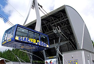
Glacier 3000 is a company that operates several cable cars. It was created in 2005 and took over the assets of the then bankrupt Glacier 3000 Région Les Diablerets-Gstaad S.A., founded in 1993. The company is now based in Gstaad(Switzerland).

Sanetsch Pass is a high mountain pass in Switzerland across the western Bernese Alps, connecting Gsteig in the canton of Bern and Sion in the canton of Valais. Although a road leads to the pass from Sion and goes further to the Lac de Sanetsch, it can not be completely traversed by car. In the summer season the pass is accessible by PostBus and can also be traversed by cable car. The highest point of the road is at 2,252 metres.

The Grand Mountet Hut is a mountain hut located in the Pennine Alps near Zinal in the canton of Valais in Switzerland. It is used at a start point for the ascents of Besso, Zinalrothorn, Ober Gabelhorn, Trifthorn, Mont Durand, Pointe de Zinal, Grand Cornier and Dent Blanche.

Les Diablerets is a village and ski resort located in the municipality of Ormont-Dessus in the canton of Vaud, Switzerland.
The Tête aux Chamois is a summit of the Diablerets massif, overlooking the Col du Pillon in the canton of Vaud. It is accessible by aerial tramway from the Col du Pillon and from Reusch via Oldenegg. From the summit of the Tête aux Chamois another aerial tramway leads to the summit of the Scex Rouge and the nearby Tsanfleuron Glacier.

Peak Walk is a pedestrian suspension bridge linking two mountain peaks in the Swiss Alps. It is situated in the Diablerets massif of the Bernese Alps in the canton of Vaud, and connects the peak of Scex Rouge with another peak. On the other peak is the viewpoint of the Glacier 3000 company. Scex Rouge is about 5 m (16 ft) higher than Glacier 3000's viewpoint. Peak Walk is the world's first suspension bridge which connects two mountain peaks.

The Quille du Diable is a peak of the Diablerets massif, located on the border of the municipalities of Conthey and Savièse in the canton of Valais. It lies on the edge of the high Tsanfleuron Glacier plateau and overlooks the valley around of Derborence 1,500 metres (4,900 ft) lower.

Aigle railway station is a railway station in the municipality of Aigle, in the Swiss canton of Vaud. It is an intermediate stop on the standard gauge Simplon line of Swiss Federal Railways and the terminus of three 1,000 mm gauge lines operated by Transports Publics du Chablais: the Aigle–Leysin, Aigle–Ollon–Monthey–Champéry, and Aigle–Sépey–Diablerets lines.
