Diamante River

Last updated
Diamante River valley, near San Rafael, Mendoza Rio Diamante San Rafael Mendoza.jpg
Diamante River valley, near San Rafael, Mendoza

The Diamante River is a river in the Argentine province of Mendoza. It is born from glaciers on the Maipo, a volcano in the Andes range in the Argentine–Chilean border, and flows east until emptying in the Desaguadero River. Its drainage basin covers an area of 2,750 square kilometres (1,060 sq mi) in the central region of Mendoza.

Argentina federal republic in South America

Argentina, officially the Argentine Republic, is a country located mostly in the southern half of South America. Sharing the bulk of the Southern Cone with Chile to the west, the country is also bordered by Bolivia and Paraguay to the north, Brazil to the northeast, Uruguay and the South Atlantic Ocean to the east, and the Drake Passage to the south. With a mainland area of 2,780,400 km2 (1,073,500 sq mi), Argentina is the eighth-largest country in the world, the fourth largest in the Americas, and the largest Spanish-speaking nation. The sovereign state is subdivided into twenty-three provinces and one autonomous city, Buenos Aires, which is the federal capital of the nation as decided by Congress. The provinces and the capital have their own constitutions, but exist under a federal system. Argentina claims sovereignty over part of Antarctica, the Falkland Islands, and South Georgia and the South Sandwich Islands.

Provinces of Argentina

Argentina is subdivided into twenty-three provinces and one autonomous city, Buenos Aires, which is the federal capital of the nation as decided by Congress. The provinces and the capital have their own constitutions, but exist under a federal system.

Mendoza Province Province of Argentina

The Province of Mendoza is a province of Argentina, located in the western central part of the country in the Cuyo region. It borders to the north with San Juan, the south with La Pampa and Neuquén, the east with San Luis, and to the west with the republic of Chile; the international limit is marked by the Andes mountain range. Its capital city is the homonymous city of Mendoza.

Course

The Diamante is fed by ice-thaw-fed streams that flow into its source, the Diamante Lake. It has an average flow of 33 cubic metres per second (1,200 cu ft/s), with its maximum during the spring and summer; the October–March period accounts for 70 percent of the annual water volume.

The upper course of the river turns south and then back north, and becomes entrenched within the deep, narrow Agua del Toro Canyon, where it is dammed to produce hydroelectricity by the Agua del Toro Dam, at about 69° W, and a few kilometres later by the Los Reyunos Dam. Together these two power stations generate 500 MW.

Entrenched river

An entrenched river, or entrenched stream is a river or stream that flows in a narrow trench or valley cut into a plain or relatively level upland. In the case of or either an entrenched stream or river, it is often presumed that the watercourse has inherited its course by cutting down into bedrock from a pre-existing plain with little modification of the original course. The down-cutting of the river system could be the result not only of tectonic uplift but also of other factors such as river piracy, decrease of load, increase of runoff, extension of the drainage basin, or change in base level such as a fall in sea level. General, nongeneric terminology for either a river or stream that flows in a narrow trench or valley, for which evidence of a preexisting plain or relatively level upland can be either absent or present is either valley meander or meander valley with the latter term being preferred in literature.

Dam A barrier that stops or restricts the flow of surface or underground streams

A dam is a barrier that stops or restricts the flow of water or underground streams. Reservoirs created by dams not only suppress floods but also provide water for activities such as irrigation, human consumption, industrial use, aquaculture, and navigability. Hydropower is often used in conjunction with dams to generate electricity. A dam can also be used to collect water or for storage of water which can be evenly distributed between locations. Dams generally serve the primary purpose of retaining water, while other structures such as floodgates or levees are used to manage or prevent water flow into specific land regions. The earliest known dam is the Jawa Dam in Jordan, dating to 3,000 BC.

Hydroelectricity electricity generated by hydropower

Hydroelectricity is electricity produced from hydropower. In 2015, hydropower generated 16.6% of the world's total electricity and 70% of all renewable electricity, and was expected to increase about 3.1% each year for the next 25 years.

Upon reaching the plain, the Diamante loses part of its volume through infiltration and evaporation. It turns in a gentle arc, passing south of the city of San Rafael, in the geographical center of Mendoza, where it is used for irrigation (together with the Atuel River).

San Rafael, Mendoza City in Mendoza, Argentina

San Rafael is a city in the southern region of the Mendoza Province, Argentina. With more than 118,000 inhabitants, it is the largest city and the seat of San Rafael Department.

Irrigation artificial application of water to the land or soil

sultan anas maked dams for free

Atuel River river in Argentina

The Atuel River is a river located mainly in the south of the Argentine province of Mendoza, with its last part in La Pampa. It is a tributary of the Desaguadero River.

The river splits in multiple branches shortly before reaching the Desaguadero (here called Salado), on the border with the province of San Luis.

San Luis Province Province of Argentina

San Luis is a province of Argentina located near the geographical center of the country. Neighboring provinces are, from the north clockwise, La Rioja, Córdoba, La Pampa, Mendoza and San Juan.

Related Research Articles

The geography of Argentina describes the geographic features of Argentina, a country located in southern South America. Bordered by the Andes in the west and the South Atlantic Ocean to the east, neighboring countries are Chile to the west, Bolivia and Paraguay to the north, and Brazil and Uruguay to the northeast.

Colorado River (Argentina) river in Argentina

The Colorado River is a river in the south of Argentina.

San Juan Province, Argentina Province of Argentina

San Juan is a province of Argentina, located in the western part of the country. Neighbouring provinces are, moving clockwise from the north, La Rioja, San Luis and Mendoza. It borders with Chile at the west.

Paraná River river in South America

The Paraná River is a river in south Central South America, running through Brazil, Paraguay, and Argentina for some 4,880 kilometres (3,030 mi). It is second in length only to the Amazon River among South American rivers. The name Paraná is an abbreviation of the phrase "para rehe onáva", which comes from the Tupi language and means "like the sea". It merges first with the Paraguay River and then farther downstream with the Uruguay River to form the Río de la Plata and empties into the Atlantic Ocean.

Salado River (Argentina) river in Argentina

The Salado River is a river that crosses several provinces of Argentina, flowing 1,150 kilometres (710 mi) from its source in the Salta Province to end in the Paraná River, in the Santa Fe Province. Because its origin, its flow varies widely within the year, and it can dry out in some parts of its path during the winter. The only important tributary to the river is the Horcones River, which is born in Salta as Cajón River, and joins the Salado in the Santiago del Estero Province.

Desaguadero River river in Argentina

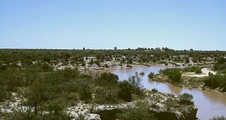
The Desaguadero River is a river in Argentina. Originating near the Tipas volcano in La Rioja at about 5,500 m (18,000 ft) elevation, the river is known in its upper reaches as the Bermejo or Vinchina. In its lower reaches it is also known as the Salado. It joins the Colorado River in La Pampa Province near Pichi Mahuida. The Desaguadero River has a total length of 1,498 km (931 mi) and its drainage basin is about 260,000 km2 (100,000 sq mi).

Jáchal River watercourse in Argentina

The Jáchal River is a river in the province of San Juan, Argentina. It is part of the Desaguadero River basin, and one of the most important permanent watercourses in the province, with an average flow of 9 cubic metres per second (320 cu ft/s). It is born from the confluence of the Río de la Palca and the Blanco River, in the northwest of San Juan.

San Juan River (Argentina) river in the Argentine province of San Juan

The San Juan River is, together with the Jáchal, the most important river of the Argentine province of San Juan. Both join the Desaguadero/Colorado system that ends at the Atlantic Ocean.

Mendoza River curso de agua en Argentina

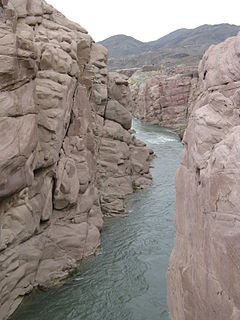
The Mendoza River is a river in the province of Mendoza, Argentina. It is formed in the Andes range between the Aconcagua and the Tupungato, by the confluence of the Vacas, the Cuevas and the Tupungato rivers, the last being its major tributary.

The Tunuyán River is a river in the Argentine province of Mendoza. It is born in Mount Tupungato, in the Andes range, and flows initially to the northeast, passing by the city of Tunuyán. It is then dammed by the El Carrizal Dam, after which it turns east-southeast passing near the cities of Rivadavia, Santa Rosa and La Paz. Finally, it branches into the Tunuyán Nuevo (north) and Tunuyán Viejo (south), and empties into the Desaguadero River.

Los Reyunos Dam

The Los Reyunos Dam is an embankment dam on the Diamante River, in central Mendoza Province, Argentina, some twenty-two miles from the city of San Rafael. The dam, built of stone and compacted clay to minimize execution and cost, is 440 feet high and contains a reservoir covering an area of 1,828 acres.

Water resources management in Argentina

Water resources management (WRM) functions in Argentina are handled by multiple institutions operating at the national, provincial, and river basin level, with a variety of functions and jurisdictions. On the national level, the National Institute for Water and the Environment (INA) and the National Water and Sanitation Utility (AySA) are charged with the duties of researching, water resources preservation, developing services, and implementing water projects.

Sierra de las Quijadas National Park national park

The Sierra de las Quijadas National Park is a national park located in the northwestern part of the Argentine province of San Luis. It was established on December 10, 1991, to protect the natural features, representative of the Semiarid Chaco and the Argentine Low Monte ecoregions.

Agua del Toro Dam

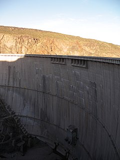
The Agua del Toro Dam is an arch dam on the Diamante River about 63 kilometres (39 mi) west of San Rafael in Mendoza Province, Argentina. The primary purpose of the dam is hydroelectric power generation and it supports a 150 megawatts (200,000 hp) power station located downstream. Construction on the dam began in 1966 and it was completed in 1973. The power station was started the same year and commissioned in 1982. The dam and power station is part of the Rio Diamante System which is owned jointly by Hidroeléctrica Diamante (HIDISA) and Hidroeléctrica de los Nihuiles (HINISA).

Infiernillo is a volcanic field in Argentina. The field is located northwest of Malargue, at the Rio Salado. The volcanic field, part of the Southern Volcanic Zone, has formed three individual vents with associated lava flows.

Argentine Monte

The Argentine Monte (NT0802), or Low Monte, is an ecoregion of dry thorn scrub and grasslands in Argentina. It is one of the driest regions in the country. Human settlements are mainly near water supplies such as rivers or oases. Deforestation and over-grazing around these settlements have caused desertification.

References

Coordinates: 34°28′S64°45′W / 34.467°S 64.750°W / -34.467; -64.750

Geographic coordinate system Coordinate system

A geographic coordinate system is a coordinate system that enables every location on Earth to be specified by a set of numbers, letters or symbols. The coordinates are often chosen such that one of the numbers represents a vertical position and two or three of the numbers represent a horizontal position; alternatively, a geographic position may be expressed in a combined three-dimensional Cartesian vector. A common choice of coordinates is latitude, longitude and elevation. To specify a location on a plane requires a map projection.