
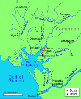
The Dibamba River is in the Littoral Region of southern Cameroon, emptying into the Cameroon estuary near the city of Doula.
The Dibamba River is in the Littoral Region of southern Cameroon, emptying into the Cameroon estuary near the city of Doula.
The Dibamba river has a length of 150 kilometres (93 mi) and a catchment area of 2,400 square kilometres (930 sq mi). Average discharge at the river mouth is 480 cubic meters per second. [1] At its mouth, the river is tidal, and flows into the estuary through mangrove forests that extend south from Doualla to Point Souelaba. [2] Near Douala, the river is crossed by a 370 metres (1,210 ft) T-section girder road bridge built of precast, prestressed concrete in 1983 - 1984. [3]

The Duala people, who today inhabit the region in and around the city of Douala, moved to their present-day location from Piti on the Dibamba river, displacing Bassa-Bakoko cultivators. Duala traditions say they are descendants of Mbedi, son of Mbongo, who lived in Piti. [4] Monneba was a Duala leader on the Cameroon coast in the 1630s, engaged in trading in ivory and slaves with the Europeans. Dutch maps from the 1650s place Monneba's name on the Dibamba River, which is called Monneba's Creek or Channel (Monnebasa Gat). [5]
The Dibamba was the scene of naval hostilities during World War I, when Commander Ralph Stuart Sneyd engaged and sank a large German launch on 10 September 1914, and drove the enemy out of their post at Piti. [6]

Douala's Bassa industrial zone ends in the estuarine creek formation of the Dibamba River, discharging pollutants. The wetlands are quickly being colonized by invasive species, and a great number of phytoplankton have been identified, some of which are caused by the pollution.[ citation needed ] Further inland, there are still some patches of permanent swamp forest on the river, but many others have been cleared and drained for oil palm plantation. The fauna of river are not well protected. The African Manatee (Trichechus senegalensis) is endangered. [7]

At 475,440 km2 (183,570 sq mi), Cameroon is the world's 53rd largest country. It is slightly larger than the nation of Sweden and US state of California. It is comparable in size to Papua New Guinea. Cameroon's landmass is 472,710 km2 (182,510 sq mi), with 2,730 km2 (1,050 sq mi) of water.

The Duala are a Bantu ethnic group of Cameroon. They primarily inhabit the littoral and southwest region of Cameroon and form a portion of the Sawabantu or "coastal people" of Cameroon. The Dualas readily welcomed German and French colonial policies The number of German-speaking Africans increased in four West African German colonies prior to 1914. The Duala leadership in 1884 placed the tribe under German rule. Most converted to Protestantism and were schooled along German lines. Colonial officials and businessmen preferred them as inexpensive clerks to German government offices and firms in Africa. They have historically played a highly influential role in Cameroon due to their long contact with Europeans, high rate of education, and wealth gained over centuries as slave traders and landowners.
The Mungo (Moungo) are an ethnic group of the Republic of Cameroon. Along with the other coastal peoples, they belong to the Sawa ethnic groups. The Mungo have historically been dominated by the Duala people, and the two groups share similar cultures, histories, and claims of origin.
A jengu is a water spirit in the traditional beliefs of the Sawa ethnic groups of Cameroon, particularly the Duala, Bakweri, Malimba, Batanga, Bakoko,Oroko People and related Sawa peoples. Among the Bakweri, the name is liengu. Miengu are similar to Mami Wata spirits Bakoko the name is Bisima.
The Mulimba are an ethnic group of the Republic of Cameroon. They belong to the Sawa peoples, those of the Cameroonian coast.
Ewale a Mbedi was the eponymous ancestor of the Duala people of Cameroon. According to the oral histories of the Duala and related Sawa peoples of the Cameroon coast, Ewale hailed from a place called Piti. He and his followers migrated southwest to the coast and settled at the present-day location of Douala. The area was inhabited by the Bassa and/or Bakoko, who were driven inland by the new arrivals. Meanwhile, Ewale and his followers set up trade with European merchant ships.
Mbedi a Mbongo is the common ancestor of many of the Sawa coastal ethnic groups of Cameroon according to their oral traditions. Stories say that he lived at a place called Piti, northeast of present-day Douala. From there, his sons migrated south toward the coast in what are known as the Mbedine events. These movements may be mythical in many cases, but anthropologists and historians accept the plausibility of a migration of some Sawa ancestors to the coast during the 16th century.

Monneba, also spelled Moneba and other ways, was a local Duala leader on the Cameroon coast in the 1630s. Dutch sources from the 1660s say that Monneba ran a trading post on the Cameroons River at the present location of Douala. His people dealt primarily in ivory, with some slaves. Modern scholars equate Monneba with a Duala ruler named Mulobe a Ewale or Mulabe a Ewale. Assuming this is true, he is the earliest Duala leader of whom we have corroboration in written sources. It is quite possible that Monneba/Mulobe was the ruler who set into motion the transformation of the Duala into a trading people and the most influential ethnic group in early Cameroonian history.
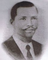
Rudolf Duala Manga Bell was a Duala king and resistance leader in the German colony of Kamerun (Cameroon). After being educated in both Kamerun and Europe, he succeeded his father Manga Ndumbe Bell on 2 September 1908, styling himself after European rulers, and generally supporting the colonial German authorities. He was quite wealthy and educated, although his father left him a substantial debt.
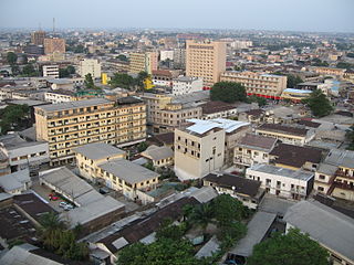
Douala is the largest city in Cameroon and its economic capital. It is also the capital of Cameroon's Littoral Region. Home to Central Africa's largest port and its major international airport, Douala International Airport (DLA), it is the commercial and economic capital of Cameroon and the entire CEMAC region comprising Gabon, Congo, Chad, Equatorial Guinea, Central African Republic and Cameroon. Consequently, it handles most of the country's major exports, such as oil, cocoa and coffee, timber, metals and fruits. As from 2018, the city and its surrounding area had an estimated population of 2,768,400. The city sits on the estuary of Wouri River and its climate is tropical.

The Mungo River is a large river in Cameroon that drains the mountains in the southern portion of the Cameroon line of active and extinct volcanoes.
Mundame or Moundamé is a community in Cameroon, in the Southwest Region, about 2 kilometres (1.2 mi) from the Mungo River. The river is navigable south of Mundame for about 100 kilometres (62 mi) as it flows through the coastal plain before entering mangrove swamps, where it splits into numerous small channels that empty into the Cameroon estuary complex.

Cross River is the main river in southeastern Nigeria and gives its name to Cross River State. It originates in Cameroon, where it takes the name of the Manyu River. Although not long by African standards its catchment has high rainfall and it becomes very wide. Over its last 80 kilometres (50 mi) to the sea its flows through swampy rainforest with numerous creeks and forms an inland delta near its confluence with the Calabar River, about 20 kilometres (12 mi) wide and 50 kilometres (31 mi) long between the cities of Oron on the west bank and Calabar, on the east bank, more than 30 kilometres (19 mi) from the open sea. The delta empties into a broad estuary which it shares with a few smaller rivers. At its mouth in the Atlantic Ocean, the estuary is 24 kilometres (15 mi) wide. The eastern side of the estuary is in the neighbouring country of Cameroon.
Auguste Manga Ndumbe Bell was a leader of the Duala people of southern Cameroon from 1897 to 1908 during the period after the German colonialists assumed control of the region as the Kamerun colony.

Ndumbé Lobé Bell or King Bell was a leader of the Duala people in Southern Cameroon during the period when the Germans established their colony of Kamerun. He was an astute politician and a highly successful businessman.
The Wouri estuary, or Cameroon estuary is a large tidal estuary in Cameroon where several rivers come together, emptying into the Bight of Biafra. Douala, the largest city in Cameroon, is at the mouth of the Wouri River where it enters the estuary. The estuary contains extensive mangrove forests, which are being damaged by pollution and population pressures.
The Naval operations of the Kamerun Campaign were carried out by German and Allied forces during the Kamerun Campaign of the First World War from August to September 1914. Naval activity occurred all along the coast of German Kamerun in the Bight of Bonny but most of the action took place in the Wouri estuary. The main event of the campaign were the successful British and French amphibious landings at Duala. The operations carried out by British and French naval forces concluded in securing control over the German colony's entire coastline and the destruction of any German naval vessels that were capable of offering resistance. Allied occupation of the coastline forced the Germans to retreat into the interior of Kamerun where they would meet their defeat in 1916.

The former police station situated in Douala is a building constructed at the beginning of the 20th century by the Germans to serve as the first police station under the German mandate.
The following is a timeline of the history of the city of Douala, Cameroon.

The Burrum River is a river located in the Wide Bay-Burnett region of Queensland, Australia.