Monneba

Last updated

Detail from an English map of 1729 showing "Monabaes vil." on the River Cameronis. 1729 West Africa map (Cameroon & Nigeria).jpg
Detail from an English map of 1729 showing "Monabaes vil." on the River Cameronis.

Monneba, also spelled Moneba and other ways, (fl. c. 1630) was a local Duala leader on the Cameroon coast in the 1630s. Dutch sources from the 1660s say that Monneba ran a trading post on the Cameroons River (the Wouri) at the present location of Douala. His people dealt primarily in ivory, with some slaves. Modern scholars equate Monneba with a Duala ruler named Mulobe a Ewale or Mulabe a Ewale. Assuming this is true, he is the earliest Duala leader of whom we have corroboration in written sources. It is quite possible that Monneba/Mulobe was the ruler who set into motion the transformation of the Duala into a trading people and the most influential ethnic group in early Cameroonian history. [1]

The Duala are an ethnic group of Cameroon. They primarily inhabit the littoral region to the coast and form a portion of the Sawabantu or "coastal peoples" of Cameroon. They have historically played a highly influential role in Cameroon due to their long contact with Europeans, high rate of education, and wealth gained over centuries as slave traders and landowners.

Cameroon Republic in West Africa

Cameroon, officially the Republic of Cameroon, is a country in Central Africa. It is bordered by Nigeria to the west and north; Chad to the northeast; the Central African Republic to the east; and Equatorial Guinea, Gabon and the Republic of the Congo to the south. Cameroon's coastline lies on the Bight of Biafra, part of the Gulf of Guinea and the Atlantic Ocean. Although Cameroon is not an ECOWAS member state, it is geographically and historically in West Africa with the Southern Cameroons which now form her Northwest and Southwest Regions having a strong West African history. The country is sometimes identified as West African and other times as Central African due to its strategic position at the crossroads between West and Central Africa.

Wouri River river in Cameroon

The Wouri is a river in Cameroon. Cameroon has two major rivers, the Sanaga, the longest with about 525 km long and the Wouri, the largest. The Wouri forms at the confluence of the rivers Nkam and Makombé, 32 km (20 mi) northeast of the city of Yabassi. It then flows about 160 km (99 mi) southeast to the Wouri estuary at Douala, the chief port and industrial city in the southwestern part of Cameroon on the Gulf of Guinea. The river is navigable about 64 km (40 mi) upriver from Douala.

Contents

Monneba in European sources

Dutch sources from the early 17th century provide some insight into nascent European trade on the Cameroons River (Wouri) at the present site of Douala. Arnout Leers, probably drawing from writings by Samuel Blommaert in the 1630s, is the first writer to mention Monneba:

Douala Place in Littoral, Cameroon

Douala is the largest city in Cameroon and its economic capital. It is also the capital of Cameroon's Littoral Region. Home to Central Africa's largest port and its major international airport, Douala International Airport (DLA), it is the commercial and economic capital of Cameroon and the entire CEMAC region comprising Gabon, Congo, Chad, Equatorial Guinea, Central African Republic and Cameroon. Consequently, it handles most of the country's major exports, such as oil, cocoa and coffee, timber, metals and fruits. As from 2018, the city and its surrounding area had an estimated population of 2,768,400. The city sits on the estuary of Wouri River and its climate is tropical.

Samuel Blommaert was a Flemish/Dutch merchant and director of the Dutch West India Company from 1622 to 1629 and again from 1636 to 1642. In the latter period he was a paid commissioner of Sweden in the Netherlands and he played a dubious but key role in Pierre Minuit's expedition that led to the Swedish colonizing of New Sweden. In 1645 he was appointed for a third time as a manager of the WIC, being one of the main investors from the beginning.

Euro-Cameroon trade was in its infancy, and these customs duties indicate that Monneba's trading post was of lesser import than that of a leader called Samson (probably an Ibibio) on the Rio del Rey farther north. [3] Rulers farther south in Gaboon (Gabon) received even more custom. [4]

Ibibio people ethnic group

The Ibibio people are from southern Nigeria. They are mostly found in Akwa Ibom, Cross River,and on the Eastern Part of Abia.They are related to the Anaang Igbo and Efik peoples. During the colonial period in Nigeria, the Ibibio Union asked for recognition by the British as a sovereign nation. The Annang, Efik, Ekid, Oron and Ibeno share personal names, culture, and traditions with the Ibibio, and speak closely related varieties of Ibibio-Efik which are more or less mutually intelligible.

Rio del Rey

The Rio del Rey is an estuary of a drainage basin in West Africa in Cameroon. It is located in the eastern area of the Niger River system. The Cameroon volcanic line separates Rio Del Rey from the Douala basin. Rio del Rey has been described as an estuary in which "the two rivers N'dian and Massake flow out". The mouth is close to the border with Nigeria and has connections to the Cross River estuary from which it is separated by the Bakassi peninsula. The Rio del Rey estuary has been designated as a Ramsar site since 2010.

Gabon country in Africa

Gabon, officially the Gabonese Republic, is a country on the west coast of Central Africa. Located on the equator, Gabon is bordered by Equatorial Guinea to the northwest, Cameroon to the north, the Republic of the Congo on the east and south, and the Gulf of Guinea to the west. It has an area of nearly 270,000 square kilometres (100,000 sq mi) and its population is estimated at 2 million people. Its capital and largest city is Libreville.

Dutch maps from the 1650s clearly label Monneba's Village (Monna Baes dorp[ sic ]), [5] located on the site of Belltown in Douala. The maps also place Monneba's name on the Dibamba River, which is called Monneba's Creek or Channel (Monnebasa Gat). [6]

The Latin adverb sic inserted after a quoted word or passage indicates that the quoted matter has been transcribed or translated exactly as found in the source text, complete with any erroneous, archaic, or otherwise nonstandard spelling. It also applies to any surprising assertion, faulty reasoning, or other matter that might be likely interpreted as an error of transcription.

Dibamba River The Dibamba River is in the Littoral Region of southern Cameroon, emptying into the Cameroon estuary near the city of Doula

The Dibamba River is in the Littoral Region of southern Cameroon, emptying into the Cameroon estuary near the city of Doula.

O. Dapper writing in 1668 (also drawing from Blommaert) explains that by that date Samson had been driven out by "those of Ambo" (Ambas Bay) and Monneba had become the lead trader in the region:

Ambas Bay

Ambas Bay is a bay of southwest Cameroon.

Dapper also describes Monneba's people:

By this time, Dutch trade on the Guinea coast had been regularised, and ships carried detailed instructions for reaching the various trading posts, including Monneba's Village. [9] Nevertheless, trade remained minimal and infrequent.

Guinea (region) region of Africa

Guinea is a traditional name for the region of the African coast of West Africa which lies along the Gulf of Guinea. It is a naturally moist tropical forest or savanna that stretches along the coast and borders the Sahel belt in the north.

As late as 1739, letters and ships' logs show that Dutch merchants on the Cameroon coast were trading almost solely with the Duala in their settlement on the Wouri, which they still referred to as "Monneba's Village". [10] Trade was mostly in ivory, with some slaves. [11] Monneba himself was still thought to be the ruler there, as Bardot wrote in 1732 (probably using Dapper as the source): "The lands opposite to the latter places, on the north of Rio Camerones, are inhabited by the Calbonges, . . . governed by a chief of their own tribe, called by them Moneba . . . ." [12] Not until King Joss in the late 1780s do European sources name another ruler from the Douala area. [11]

Connection with Mulobe a Ewale

Edwin Ardener equates Monneba with the Duala leader referred to in traditional genealogies as Mulobe a Ewale or Mulabe a Ewale. [13] This individual is placed one generation after Ewale a Mbedi, the eponymous father of the Duala people. Later academics Austen and Derrick accept the Monneba/Mulabe connection as "very reasonable". [14]

There is no doubt that Monneba's Village is in fact Douala. The location on Dutch maps is clearly on the Wouri River at about the location of Belltown, one of the various townships that made up Douala in the precolonial period. [5] Leers and Blommaert give examples of the language spoken by Monneba and his people, and it is obviously that of the Duala. [14] The connection also makes temporal sense. If one starts from the first incontestable Duala leaders known from modern sources and traces their purported genealogy back allowing 25 years for each generation, Mulobe seems to have lived at the same time Dutch sources first mention Monneba. [6]

Notes

  1. Ardener and Ardener 362.
  2. Leers, Arnout (1665). Pertinente Beschryvinge van Africa . . . Getrocken en vergadert uyt de Reysboeken van Johannes Leo Africanus. Rotterdam. P. 313. Quoted in Ardener 20. Emphasis in original.
  3. Austen and Derrick 17–18.
  4. Ardener 20–1.
  5. 1 2 Ardener 24.
  6. 1 2 Austen and Derrick 17.
  7. Dapper quoted in Ardener 24–5.
  8. Dapper quoted in Ardener 14–15. Emphasis in original.
  9. Ardener 23.
  10. Austen and Derrick 19.
  11. 1 2 Austen and Derrick 23.
  12. Quoted in Ardener 15.
  13. Ardener 16.
  14. 1 2 Austen and Derrick 15.

Related Research Articles

Subu people Cameroonian ethnic group

The Isubu are an ethnic group who inhabit part of the coast of Cameroon. Along with other coastal peoples, they belong to Cameroon's Sawa ethnic groups. They were one of the earliest Cameroonian peoples to make contact with Europeans, and over two centuries, they became influential traders and middlemen. Under the kings William I of Bimbia and Young King William, the Isubu formed a state called Bimbia.

A jengu is a water spirit in the traditional beliefs of the Sawa ethnic groups of Cameroon, particularly the Duala, Bakweri, and related Sawa peoples. Among the Bakweri, the name is liengu. Miengu are similar to Mami Wata spirits.

The Mulimba are an ethnic group of the Republic of Cameroon. They belong to the Sawa peoples, those of the Cameroonian coast.

Ewale a Mbedi was the eponymous ancestor of the Duala people of Cameroon. According to the oral histories of the Duala and related Sawa peoples of the Cameroon coast, Ewale hailed from a place called Piti. He and his followers migrated southwest to the coast and settled at the present-day location of Douala. The area was inhabited by the Bassa and/or Bakoko, who were driven inland by the new arrivals. Meanwhile, Ewale and his followers set up trade with European merchant ships.

Mbedi a Mbongo is the common ancestor of many of the Sawa coastal ethnic groups of Cameroon according to their oral traditions. Stories say that he lived at a place called Piti, northeast of present-day Douala. From there, his sons migrated south toward the coast in what are known as the Mbedine events. These movements may be mythical in many cases, but anthropologists and historians accept the plausibility of a migration of some Sawa ancestors to the coast during the 16th century.

Mbongo is the common ancestor of the Sawa peoples of Cameroon according to their oral traditions. Sawa genealogies usually place Mbongo at the head of the lineage. Mbongo's son, usually given as Mbedi a Mbongo, lived at Piti on the Dibamba River. From there, Mbongo's grandsons migrated south toward the coast to found the various Sawa ethnic groups. Some stories make these migrants Mbongo's sons rather than grandsons.

George or Joss, born Doo a Makongo or Doo a Mukonga, was a king of the Duala people in the late 18th century. Doo a Makongo was the son of Makongo a Njo. He lived at Douala on the Wouri estuary on the coast of Cameroon. By 1788–1790, Doo was a powerful ruler in the area. During this time, the British slave trade was at its height, and Douala was the primary trading post in the region.

Kwane a Ngie, known in British records as Angua or Quan, was a Duala ruler from the Bonambela sublineage who flourished from 1788 to 1790 in Douala, Cameroon. The British slave trade was at its height at this time, and, although a rival ruler from the Bonanjo sublineage named George or Joss reigned simultaneously, British records point to Kwane as the more powerful or respected leader.

Priso a Doo, also known as Preshaw, Preese, and possibly Peter, was a Duala ruler who lived on the Wouri River of the Cameroons in the late 18th century. His violent behaviour lost him his birthright and catalysed the split of the Duala people into rival Bell and Akwa sublineages.

Elame a Doo was a ruler of the Bonapriso sublineage of the Duala people who lived on the Wouri estuary of Cameroon in the late 19th century. He was the son of Doo a Priso and the grandson of Priso a Doo. Elame signed the 1884 German-Duala treaty that granted the German Empire sovereignty over Cameroon.

Rudolf Duala Manga Bell Duala rebel king executed during German rule over Cameroon

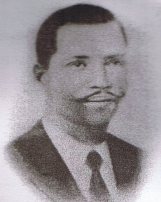
Rudolf Duala Manga Bell was a Duala king and resistance leader in the German colony of Kamerun (Cameroon). After being educated in both Kamerun and Europe, he succeeded his father Manga Ndumbe Bell on 2 September 1908, styling himself after European rulers, and generally supporting the colonial German authorities. He was quite wealthy and educated, although his father left him a substantial debt.

Ewonde a Kwane was a Duala ruler of the Bonambela/Akwa lineage who lived in Douala on the Wouri River. Ewonde was the son of the powerful chief Kwane a Ngie. Ewonde died early, causing a secession crisis in Bonambela. Ngando a Kwa claimed to be his heir and declared himself equal to Bele a Doo, leader of the Bonanjo/Bell lineage. Ewonde's daughter Kanya married Enjobe, an Aboh slave or immigrant in Douala. Their son would found the Bonambele/Deido sublineage. Duala tradition states that another of Ewonde's daughters, Lesenge, married into Isubu royalty and was the mother of King William of Bimbia.

Mundame Place in Southwest, Cameroon

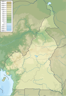
Mundame or Moundamé is a community in Cameroon, in the Southwest Region, about 2 kilometres (1.2 mi) from the Mungo River. The river is navigable south of Mundame for about 100 kilometres (62 mi) as it flows through the coastal plain before entering mangrove swamps, where it splits into numerous small channels that empty into the Cameroon estuary complex.

Auguste Manga Ndumbe Bell was a leader of the Duala people of southern Cameroon from 1897 to 1908 during the period after the German colonialists assumed control of the region as the Kamerun colony.

Ndumbe Lobe Bell Cameroonian traditional ruler

Ndumbé Lobé Bell or King Bell was a leader of the Duala people in Southern Cameroon during the period when the Germans established their colony of Kamerun. He was an astute politician and a highly successful businessman.

Jantzen & Thormählen

Jantzen & Thormählen was a German firm based on Hamburg that was established to exploit the resources of Cameroon. The firm's commercial and political influence was a major factor in the establishment of the colony of Kamerun in 1884.

Wouri estuary

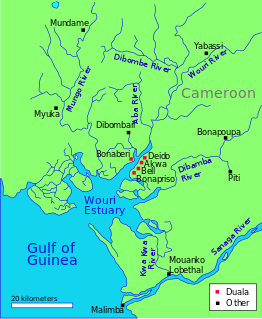
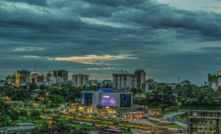
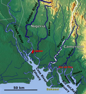
The Wouri estuary, or Cameroon estuary is a large tidal estuary in Cameroon where several rivers come together, emptying into the Bight of Biafra. Douala, the largest city in Cameroon, is at the mouth of the Wouri River where it enters the estuary. The estuary contains extensive mangrove forests, which are being damaged by pollution and population pressures.

References