
The Snake River is a major river of the greater Pacific Northwest region in the United States. At 1,078 miles (1,735 km) long, it is the largest tributary of the Columbia River, in turn, the largest North American river that empties into the Pacific Ocean. The Snake River rises in western Wyoming, then flows through the Snake River Plain of southern Idaho, the rugged Hells Canyon on the Oregon–Idaho border and the rolling Palouse Hills of Washington, emptying into the Columbia River at the Tri-Cities in the Columbia Basin of Eastern Washington.
The Bruneau River is a 153-mile-long (246 km) tributary of the Snake River, in the U.S. states of Idaho and Nevada. It runs through a narrow canyon cut into ancient lava flows in southwestern Idaho. The Bruneau Canyon, which is up to 1,200 feet (370 m) deep and 40 miles (64 km) long, features rapids and hot springs, making it a popular whitewater trip.

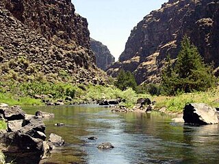
The Owyhee River is a tributary of the Snake River located in northern Nevada, southwestern Idaho and southeastern Oregon in the United States. It is 280 miles (450 km) long. The river's drainage basin is 11,049 square miles (28,620 km2) in area, one of the largest subbasins of the Columbia Basin. The mean annual discharge is 995 cubic feet per second (28.2 m3/s), with a maximum of 50,000 cu ft/s (1,400 m3/s) recorded in 1993 and a minimum of 42 cu ft/s (1.2 m3/s) in 1954.

The Portneuf River is a 124-mile-long (200 km) tributary of the Snake River in southeastern Idaho, United States. It drains a ranching and farming valley in the mountains southeast of the Snake River Plain. The city of Pocatello sits along the river near its emergence from the mountains onto the Snake River Plain.

Schoharie Creek is a river in New York that flows north 93 miles (150 km) from the foot of Indian Head Mountain in the Catskills through the Schoharie Valley to the Mohawk River. It is twice impounded north of Prattsville to create New York City's Schoharie Reservoir and the Blenheim-Gilboa Power Project.

The Los Gatos Creek runs 24 miles (39 km) in California through Santa Clara Valley Water District's Guadalupe Watershed from the Santa Cruz Mountains northward through the Santa Clara Valley until its confluence with the Guadalupe River in downtown San Jose. The Guadalupe River then continues onward into San Francisco Bay.

Johnson Creek is a 25-mile (40 km) tributary of the Willamette River in the Portland metropolitan area of the U.S. state of Oregon. Part of the drainage basin of the Columbia River, its catchment consists of 54 square miles (140 km2) of mostly urban land occupied by about 180,000 people as of 2012. Passing through the cities of Gresham, Portland, and Milwaukie, the creek flows generally west from the foothills of the Cascade Range through sediments deposited by glacial floods on a substrate of basalt. Though polluted, it is free-flowing along its main stem and provides habitat for salmon and other migrating fish.
The North Fork Clearwater River is a major tributary of the Clearwater River in the U.S. state of Idaho. From its headwaters in the Bitterroot Mountains of eastern Idaho, it flows 135 miles (217 km) westward and is dammed by the Dworshak Dam just above its mouth in north-central Idaho. Draining a rugged watershed of 2,462 square miles (6,380 km2), the river has an average flow of over 5,600 cubic feet per second (160 m3/s), accounting for a third of the discharge from the Clearwater basin. The river drains parts of Clearwater, Shoshone, Latah, and Idaho counties. Most of the watershed is managed by the U.S. Forest Service. Some of the fish of the river include westslope cutthroat trout, rainbow trout, mountain whitefish, and the threatened bull trout. It also has smallmouth bass and a kokanee salmon run, both from Dworshak Reservoir. The North Fork drainage is home to grizzly bears, cougars, deer, moose, black bear, elk, grey wolves, and osprey. The river used to have a large steelhead run before the implementation of Dworshak Dam. The North Fork of the Clearwater is located within the Clearwater National Forest

Salmon Falls Creek is a tributary of the Snake River, flowing from northern Nevada into Idaho in the United States. Formed in high mountains at the northern edge of the Great Basin, Salmon Falls Creek flows northwards 121 miles (195 km), draining an arid and mountainous basin of 2,103 square miles (5,450 km2). The Salmon Falls Creek valley served as a trade route between the Native American groups of the Snake River Plain and Great Basin. Today, most of its water is used for irrigation.
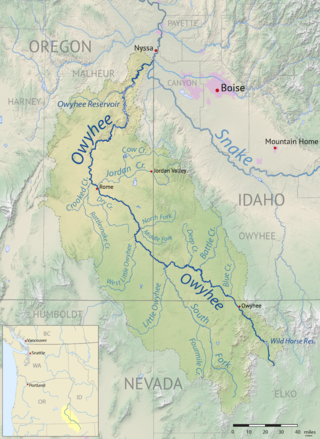
Jordan Creek is a 99-mile (159 km) tributary of the Owyhee River in the northwestern United States. It generally flows west from near Silver City, Idaho, in the Owyhee Mountains to near Rome in the Oregon High Desert. Major tributaries are Big Boulder, Soda, Louse, Spring, Rock, Meadow, Combination, and Louisa creeks in Idaho and Cow Creek in Oregon. The creek is named for Michael M. Jordan, who led a party that discovered gold along the creek in 1863.
Dickshooter is the name of a trailmarker and also of at least three features in Owyhee County, Idaho: a ridge, a reservoir, and a creek. These are in close proximity to each other in the southwestern corner of the state, in a wilderness area approximately 24 miles (39 km) northwest of Riddle.

Goose Creek is a 123-mile (198 km) long tributary of the Snake River. Beginning at an elevation of 7,239 feet (2,206 m) in the Cassia Division of the Sawtooth National Forest in southwestern Cassia County, Idaho, it flows south into Elko County, Nevada, and loops back around into Cassia County, briefly crossing Box Elder County, Utah, in the process. It is impounded by Oakley Dam several miles south of Oakley, Idaho, forming Lower Goose Creek Reservoir. All of the creek's water is stored for irrigation, so its channel from the reservoir to its mouth near Burley, Idaho, is dry and largely obliterated by agriculture. Goose Creek has a 1,120-square-mile (2,901 km2) watershed. The California Trail followed Goose Creek from a point just north of the Idaho/Utah border southwest across northwestern Utah to Little Goose Creek in northeastern Elko County, Nevada.
Little Shamokin Creek is a 15.0-mile-long (24.1 km) tributary of Shamokin Creek and a sub-tributary of the Susquehanna River in Northumberland County, Pennsylvania, in the United States. The watershed of the creek has an area of 37 square miles, spread out over Upper Augusta Township, Lower Augusta Township, Rockefeller Township, and Shamokin Township. The creek's watershed contains four rock formations. These are the Hamilton Group, the Spechty Kopf formation, the Irish Valley formation, and the Buddy Run formation. The watershed also contains three main soil types. They are the Berks-Weikert-Bedington series, the Leck Kill-Meckesville-Calvin series and the Hazelton-Dekalb-Buchanan series.

Stroubles Creek is an approximately 12-mile-long (19 km) stream that runs through the town of Blacksburg, the Virginia Tech campus, and Montgomery County, Virginia until it empties into the New River. Most of the sections of Stroubles Creek that flow through Blacksburg and the Virginia Tech campus are piped underground, while the portion that flows through Montgomery County is above-ground. Stroubles Creek has been designated an impaired waterway since 2002.
Drury Run is a tributary of the West Branch Susquehanna River in Clinton County, Pennsylvania, in the United States. It is 7.71 miles (12.41 km) long and its watershed is 11.5 square miles in area, most of which is forest. The stream's tributaries are affected by acid mine drainage, as are the lower reaches of the stream itself. It begins in Tamarack Swamp and flows through Leidy Township, Noyes Township, and Renovo. Brook trout, brown trout, creek chub, and eastern blacknose dace all inhabit the stream.
Grassy Island Creek is a tributary of the Lackawanna River in Lackawanna County, Pennsylvania, in the United States. It is approximately 4.4 miles (7.1 km) long and flows through Jefferson Township and Jessup. The watershed of the creek has an area of 5.42 square miles (14.0 km2). The lower reaches of the creek are impaired, but the upper reaches are not impaired. It is an intermittent stream during the summer, but its flow has been recorded as being as high as 116,553.21 gallons per minute. Some manganese, acidity, and alkalinity are also in the creek. It is in the Appalachian Mountain section of the ridge and valley physiographic province. The main rock formations in the creek's watershed are made of sandstone and interbedded sedimentary rocks. Some reservoirs are in the watershed at the boundary between the Pocono Formation and the Llewellyn Formation.
The North Fork Owyhee River is a tributary, about 30 miles (48 km) long, of the Owyhee River in Malheur County, Oregon, and Owyhee County, Idaho, in the United States. It begins on the east flank of the Owyhee Mountains in Idaho and flows generally southwest to meet the main stem at Three Forks, Oregon, 161 miles (259 km) above the confluence of the larger river with the Snake River.

Cottonwood Creek is a major stream and tributary of the Sacramento River in Northern California. About 68 miles (109 km) long measured to its uppermost tributaries, the creek drains a large rural area bounded by the crest of the Coast Ranges, traversing the northwestern Sacramento Valley before emptying into the Sacramento River near the town of Cottonwood. It defines the boundary of Shasta and Tehama counties for its entire length. Because Cottonwood Creek is the largest undammed tributary of the Sacramento River, it is known for its Chinook salmon and steelhead runs.


