Mount Nyiragongo is an active stratovolcano with an elevation of 3,470 m (11,385 ft) in the Virunga Mountains associated with the Albertine Rift. It is located inside Virunga National Park, in the Democratic Republic of the Congo, about 12 km (7.5 mi) north of the town of Goma and Lake Kivu and just west of the border with Rwanda. The main crater is about two kilometres (1 mi) wide and usually contains a lava lake. The crater presently has two distinct cooled lava benches within the crater walls – one at about 3,175 m (10,417 ft) and a lower one at about 2,975 m (9,760 ft).

Goma is the capital of North Kivu province in the eastern Democratic Republic of the Congo. It is located on the northern shore of Lake Kivu, next to the Rwandan city of Gisenyi. The lake and the two cities are in the Albertine Rift, the western branch of the East African Rift system. Goma lies only 13–18 km (8.1–11.2 mi) south of the active Nyiragongo Volcano. The recent history of Goma has been dominated by the volcano and the Rwandan genocide of 1994, which in turn fuelled the First and Second Congo Wars. The aftermath of these events was still having effects on the city and its surroundings in 2010. The city was captured by rebels of the March 23 Movement during the M23 rebellion in late 2012, but it has since been retaken by government forces.
Gemena Airport is an airport serving Gemena, the capital of the Sud-Ubangi District in Sud-Ubangi province in the Democratic Republic of the Congo.
Mbandaka Airport is an airport serving the Congo River port of Mbandaka, capital city of the Équateur District in the Democratic Republic of the Congo. The runway is on the southeast side of the city.

Not to be confused with Bangkok Suvarnabhumi Airport or Bangkok Don Mueang International Airport

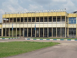
Goma International Airport is an airport serving Goma, a city in the Democratic Republic of the Congo in Africa.

Mbuji Mayi Airport is an airport serving Mbuji Mayi, the capital of the Kasai-Oriental Province in the Democratic Republic of the Congo.

Lubumbashi International Airport is an airport serving Lubumbashi, Democratic Republic of the Congo.

Kindu Airport is an airport serving the Lualaba River port of Kindu, Democratic Republic of the Congo.
Kolwezi Airport is an airport serving Kolwezi, the capital of Lualaba District in the Democratic Republic of the Congo. The airport is 6 kilometres (3.7 mi) south of Kolwezi.

Gbadolite Airport is an airport serving Gbadolite, the capital of the Nord-Ubangi Province in the Democratic Republic of the Congo. The airport is at the village of Moanda, 6 kilometres (3.7 mi) southwest of Gbadolite.

Bunia Airport is an airport serving Bunia the capital of Ituri province, Democratic Republic of the Congo.
Bangassou Airport is an airport serving Bangassou, a city on the Mbomou River in the Mbomou prefecture of the Central African Republic. The Mbomou River forms the local border with the Democratic Republic of the Congo.
N'Dolo Airport, also known as Ndolo Airport, is a secondary airport in the city of Kinshasa, Democratic Republic of the Congo, located in the commune of Barumbu near the city center.
Bumba Airport is an airport serving the Congo River port city of Bumba in Mongala Province, Democratic Republic of the Congo.
Kempa Airport was an airstrip serving the village of Kempa in Mai-Ndombe Province, Democratic Republic of the Congo.

Irumu is a territory of Ituri province, Democratic Republic of the Congo. It is located in the northeastern part of the country, 1,700 km east of the capital Kinshasa. Its administrative center is the town of Irumu.

Mahagi is a territory and a locality of Ituri province in the Democratic Republic of the Congo. It is located in the northeastern part of the country, 1,900 km east of the capital Kinshasa.
Events in the year 2021 in the Republic of the Congo.


