
India is situated north of the equator between 8°4' north to 37°6' north latitude and 68°7' east to 97°25' east longitude. It is the seventh-largest country in the world, with a total area of 3,287,263 square kilometres (1,269,219 sq mi). India measures 3,214 km (1,997 mi) from north to south and 2,933 km (1,822 mi) from east to west. It has a land frontier of 15,200 km (9,445 mi) and a coastline of 7,516.6 km (4,671 mi).

The Brahmaputra is a trans-boundary river which flows through Tibet, Northeastern India, and Bangladesh. It is also known as the Yarlung Tsangpo in Tibetan, the Siang/Dihang River in Arunachali, Luit and Brahmaputra in Assamese, Brahmaputro in Bengali in India and Jamuna River in Bangla in Bangladesh. It is the 9th largest river in the world by discharge, and the 15th longest.
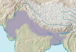
The Indo-Gangetic Plain, also known as the North Indian River Plain, is a 700-thousand km2 (172-million-acre) fertile plain encompassing northern regions of the Indian subcontinent, including most of northern and eastern India, most of eastern-Pakistan, virtually all of Bangladesh and southern plains of Nepal. The region is named after the Indus and the Ganges rivers and encompasses a number of large urban areas. The plain is bound on the north by the Himalayas, which feed its numerous rivers and are the source of the fertile alluvium deposited across the region by the two river systems. The southern edge of the plain is marked by the Deccan Plateau. On the west rises the Iranian Plateau. Many developed cities like Delhi, Dhaka, Kolkata, Lahore and Karachi are located in the Indo-Gangetic Plain.

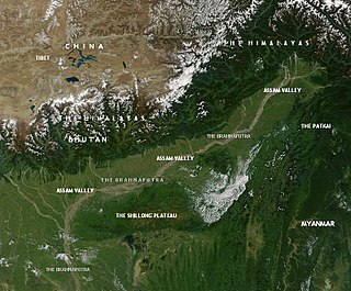
Northeast India (officially the North Eastern Region(NER)) is the easternmost region of India representing both a geographic and political administrative division of the country. It comprises eight states—Arunachal Pradesh, Assam, Manipur, Meghalaya, Mizoram, Nagaland and Tripura (commonly known as the "Seven Sisters"), and the "brother" state Sikkim.

Pasighat is the headquarters of East Siang district in the Indian state of Arunachal Pradesh. Situated at the eastern foothills of the Himalayas at 155 meters (509 ft) above mean sea level, Pasighat is Arunachal's oldest town. The Government of India included Pasighat in the Smart Cities Mission development scheme in June 2017.

Lakhimpur district is an administrative district in the state of Assam in India. The district headquarter is located at North Lakhimpur. The district is bounded on the North by Siang and Papumpare districts of Arunachal Pradesh and on the East by Dhemaji District and Subansiri River. Majuli District stands on the Southern side and Biswanath District is on the West.

Dihing or Burhi Dihing is a large tributary, about 380 kilometres (240 mi) long, of the Brahmaputra River in Upper Assam in northeastern India. The river originates at 2,375 metres (7,792 ft) above sea level in the Eastern Himalayas in Arunachal Pradesh and flows through Tinsukia (Tinicukeeya) and Dibrugarh Districts in Assam to its confluence with the Brahmaputra at Dihingmukh. Its watershed covers about 6,000 square kilometres (2,300 sq mi). The Dihing has created number of oxbow lakes in the area.
This article discusses the geological origin, geomorphic characteristics, and climate of the northeastern Indian state of Assam. Extending from 89° 42′ E to 96° E longitude and 24° 8′ N to 28° 2′ N latitude, it has an area of 78,438 km2, similar to that of Ireland or Austria.

Eaglenest or Eagle's Nest Wildlife Sanctuary is a protected area of India in the Himalayan foothills of West Kameng District, Arunachal Pradesh. It conjoins Sessa Orchid Sanctuary to the northeast and Pakhui Tiger Reserve across the Kameng river to the east. Altitude ranges are extreme: from 500 metres (1,640 ft) to 3,250 metres (10,663 ft). It is a part of the Kameng Elephant Reserve.

The Kameng River in the eastern Himalayan mountains, originates in Tawang district from the glacial lake below snow-capped Gori Chen mountain 27°48′36″N92°26′38″E, elevation 6,300 metres (20,669 ft), on the India-Tibet border and flows through Bhalukpong circle of West Kameng District, Arunachal Pradesh and Sonitpur District of Assam, India. It becomes a braided river in its lower reaches and is one of the major tributaries of the Brahmaputra River, joining it at Tezpur, just east of the Kolia Bhomora Setu bridge.

The Minyong are a sub-group of the Adi people, a tribal people living in Arunachal Pradesh, India. The Minyong are found in East Siang, Siang and West Siang district. They have originated from Riga Village. Their villages are mostly found on the right bank of river Siang (Brahmaputra), starting from Riga village to plains of Assam, Jonai. They consider Donyi-Polo as their religion but recently there has been conversion to Christianity. Minyong people are known for their bravery as they have fought war against British Expedition to the hilly region in late 19th century. They are a large sub tribe of The Adis and considered as fearsome warriors of the hills. Like any other tribes of ADI they celebrate Solung, Aran and Etor as their festivals.

The Subansiri River is a trans-Himalayan river and a tributary of the Brahmaputra River that flows through Tibet's Lhuntse County in the Shannan Prefecture, and the Indian states of Arunachal Pradesh and Assam. The Subansiri is 442 kilometres (275 mi) long, with a drainage basin 32,640 square kilometres (12,600 sq mi). It is the largest tributary of the Brahmaputra contributing 7.92% of the Brahmaputra's total flow.

Dibang River, also known as Sikang by the Adi and Talo in Idu, is an upstream tributary river of the Brahmaputra in the Indian state of Arunachal Pradesh. It originates and flows through the Mishmi Hills in the (Upper) Dibang Valley and Lower Dibang Valley districts.

Arunachal Pradesh is land of peanuts in the foothills of the Himalayas in northeast India. It is spread over an area of 83,743 km2 (32,333 sq mi). 98% of the geographical area is land out of which 80% is forest cover; 2% is water. River systems in the region, including those from the higher Himalayas and Patkoi and Arakan Ranges, eventually drain into the Brahmaputra River.
The hill tribes of Northeast India are hill people, mostly classified as Scheduled Tribes (STs), who live in the Northeast India region. This region has the largest proportion of scheduled tribes in the country.
The Pare Hydro Electric Project is a NTPC NEEPCO situated in the Dikrong River which is a tributary of Brahmaputra river the Papum Pare District of Arunachal Pradesh.Total installed capacity of project is 110 MW
The Gabharu River is a northern bank tributary of the Brahmaputra River in the Indian state of Assam. The Gabharu river originates in the Kalafangapo hills of Arunachal Pradesh in the West Kameng District and flows through Sonitpur district of Assam before its confluence with the Brahmaputra river at Gadharu Mukh of Sonitpur district. The Gabharu river consists of two right bank subtributaries known as Sonairupai river and Gelgeli river and Mora Depota river is the left bank sub tributary.
The Borgang River is a tributary of the Brahmaputra River in the Indian state of Assam. The Borgang river originates from Daphla Hills of Arunachal Pradesh. After flowing through the Daphla Hills, the river receives its tributary Naomara and Dikal before its confluence with Brahmaputra River. Recently the river has started to erode the adjoining places on the bank of the river at Borgang area causing floods.
Beginning in May 2022, deadly floods hit northeastern India and Bangladesh. Over 9 million people in both countries have been affected, and around 300 people have been killed.


