
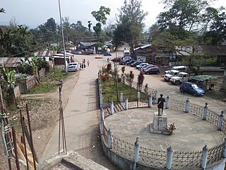
Ziro is a town in and the district headquarters of the Lower Subansiri district in the Indian state of Arunachal Pradesh. It is included the Tentative List for UNESCO's World Heritage Site for the Apatani cultural landscape. The part of the town which is the centre of economic activities and where the administrative offices are located is called Hapoli, or locally known by the Apatanis as "Hao-Polyang".
Tezu is a census town and the headquarters of Lohit district in the Indian state of Arunachal Pradesh. It is the fifth largest town in Arunachal Pradesh and one of its most developed.

Yingkiong is a town in and the administrative headquarters of Upper Siang district in the Northeast Indian state of Arunachal Pradesh. It is located 250 kilometres (160 mi) north of Itanagar, the capital of the state, and 1 kilometre east of the River Siang. According to the 2011 Census, the town has a total population of 8,573.

Bomdila is the headquarters of West Kameng district in the state of Arunachal Pradesh in India. Bomdila is one of the 60 constituencies of the state of Arunachal Pradesh.

Aalo, formerly Along, is a census town and headquarter of the West Siang district district of the Indian state of Arunachal Pradesh. It is located 137 kilometres (85 mi) from Likabali, which is at the border of Assam and Arunachal Pradesh.

Tawang is a town and administrative headquarter of Tawang district in the Indian state of Arunachal Pradesh. It lies on NH-13 section of Trans-Arunachal Highway. The town was once the headquarter of the Tawang Tract, which is now divided into the Tawang district and the West Kameng district. Tawang continues as the headquarters of the former. Tawang is the number one tourist destination of Arunachal Pradesh.
Deomali is a census town in Tirap district in the state of Arunachal Pradesh, India. The town is surrounded by hills, tea gardens, forests and rivers. It serves as the headquarters of both Deomali sub division and Namsang block. It is considered as the education hub of Tirap district and is home to Wangcha Rajkumar Government College, Deomali and renowned educational institution Ramakrishna Mission School, Narottam Nagar. Deomali also has a centre of Krishi Vigyan Kendra. The Coffee Board of India has established a Technical Evaluation Centre in Deomali, one of its such six centres in India. Additionally, Coffee Board of India maintains a 26 acres coffee plantation in Deomali. The town is 250 km from state capital Itanagar, 43 km from district headquarter Khonsa, 30 km from Margherita, 33 km from Naharkatia, 46 km from Tinsukia, 73 km from Dibrugarh and 455 km from Guwahati.

Roing is the district headquarter of Lower Dibang Valley district in the Indian state of Arunachal Pradesh. It is the last major township at the north-eastern frontier of India.
Silapathar is a city in Dhemaji district in the Indian state of Assam. The city is on the northern bank of the Brahmaputra River and is 470 kilometres (290 mi) from the city of Guwahati and just six km (3.7 mi) from border of Arunachal Pradesh. The longest rail cum road bridge in India connects Silapathar to Dibrugarh. Historical Malinithan mandir is located around ten km (6.2 mi) from Silapathar.
Jonai is the easternmost Co-District of Dhemaji District in India's Assam State, about 554 kilometers away from the state capital, Dispur. It covers a total area of 1181.2 sq. km. and is bounded by Arunachal Pradesh in the north, Lali and Brahmaputra River in the south, Sipiya river and Sadiya Subdivision of Tinsukia district in the east, and Simen River in the west. The state has the easternmost railway station of the Indian Railways, called Murkongselek railway station, in Dhemaji District. Its local residents are the Mising, Assamese and Gorkha. Some tourist attractions include the Poba Wildlife Sanctuary, which is located 3 miles away.
Kharsang is a small town located in the Changlang district of Arunachal Pradesh, India. It serves as an administrative sub-division of the district.
Murkongselek is a village in Assam. It is located in the north-eastern part of Dhemaji district, 42 km from Pasighat in Arunachal Pradesh. Tourist attractions are located nearby in Torajan dolung Jonai and Silapathar. The village also has a railway station. It is around 540 km from Guwahati. Nearest airport is pasighat Airport, East siang
Nirjuli is a town in the Papum Pare district of Arunachal Pradesh in Northeast India. It is 19 km (12 mi) away from Itanagar, the capital of Arunachal Pradesh, and it takes about 40–45 minutes by road from Nirjuli to Itanagar. The National Highway 52A is a highway that runs through the town and provides the primary platform for easy transportation and access within the town and to the outside world as well. The Par River, the only river flowing by the town which adds to its exquisite beauty, and ultimately flows into the Brahmaputra River.

Rajiv Gandhi Government Polytechnic is a multi-speciality, technology-oriented college located at Itanagar, Arunachal Pradesh. It is also the first polytechnic college in Arunachal Pradesh under the Arunachal Pradesh State Council for Technical Education (APSCTE), Government of Arunachal Pradesh. Rajiv Gandhi Government Polytechnic has also earned the credit of being the first Institution in the state to achieve ISO 9001:2000 certification in June 2006.
Vijoynagar is the most remote town and circle headquarters in the Changlang district, Arunachal Pradesh, India.
Hayuliang is a town and the headquarters of an eponymous subdivision in the Anjaw district in the north-eastern state of Arunachal Pradesh, India. It is on the bank of the Lohit River near the confluence of the Delei River.
National Highway 415 starts from Banderdewa, Arunachal Pradesh and ends at Gohpur, Assam. The highway is 59 km (37 mi) long, of which 15 km (9.3 mi) is in Assam and 42 km (26 mi) in Arunachal Pradesh.

Mayodia Pass, 56 km from Roing in Dibang Valley district of Arunachal Pradesh state in India, is a popular local tourist attraction due to the November to March winter snow fall which is heaviest in January and February.
Boleng is a town in Siang district, lying on the banks of Siang River in the Indian state of Arunachal Pradesh. It is the headquarters of the newly created Siang District, which was bifurcated from West Siang and East Siang. It is located about 100 km from Pasighat, East Siang district of Arunachal Pradesh. The district is named after the Brahmaputra, locally known as Siang.
Murkongselek Railway Station is a main railway station in Dhemaji district, Assam. Its code is MZS. It serves Murkongselek town. The station consists of three platforms. The station has been upgraded to a standard Class II Station. . It is a railway station which connects Assam to Arunachal Pradesh.

